News   Jul 16, 2024
 490     0 
News   Jul 16, 2024
 537     0 
News   Jul 16, 2024
 670     2 

TTC: Redesigning TTC Signage

I like the new signage, but I think that the RT routes should include a letter prefix indicating the type of service (S = subway, L = LRT, B = BRT, E = GO REX, R = Regional GO rail). That way, the naming convention can be applied across the entire region, and eventually routes in the 905 can be added using the same standard.

I'd rather that not happen. For political reasons, it's better to have all the RT at the same level.
 
I'd rather that not happen. For political reasons, it's better to have all the RT at the same level.

Politics is a valid concern, but the reality is that regional transit integration is probably on the horizon. By planning a naming scheme now that can be easily expandable to 905 RT lines, it could avoid a lot of headaches down the road.

And I honestly think that once the Eglinton LRT opens, having it as L2 instead of 5 isn't going to be that big of a deal. People will realize that the speed difference compared to Bloor-Danforth is almost non-existent.
 
VERY go od ideas but will the silo mentality at both organizations allow such ideas to be implimented?
That's what Metrolinx was supposed to be for, but I hear you.

I like the new signage, but I think that the RT routes should include a letter prefix indicating the type of service (S = subway, L = LRT, B = BRT, E = GO REX, R = Regional GO rail). That way, the naming convention can be applied across the entire region, and eventually routes in the 905 can be added using the same standard. The other thing I'd like to see is odd numbered routes being N-S routes, and even numbered routes being E-W routes. That may result in some of the numbering sequence being a tad out of order (more E-W routes than N-S routes), but it would make wayfinding a lot easier, knowing that, just based on the number, you can tell which on which axis you're travelling.
The mode prior to the line (i.e, S1, S2, L4, etc.) makes a degree of sense to and would be another example of where Metrolinx could show leadership, but likely won't. As per aligning even-odd with north-south and east-west... What would one consider a fully-built DRL?
 
The mode prior to the line (i.e, S1, S2, L4, etc.) makes a degree of sense to and would be another example of where Metrolinx could show leadership, but likely won't. As per aligning even-odd with north-south and east-west... What would one consider a fully-built DRL?

Very true. If the TTC is redesigning all their signage anyways, some input from Metrolinx saying "hey, why not make this tweak to your plans so it can be expanded regionally?" would make a lot of sense.

As for the DRL, I consider it a N-S route, especially considering that any future extension of any part of the line will be a N-S extension as opposed to an E-W one (up Don Mills or Jane most likely). That would make it the S3, with Sheppard being S4.
 
I like the numbering not treating subway and LRT differently. Stops spaced 500m - 2km apart apart in urban environment, frequent all day service, separated from traffic = RT. I would also use squares with letters for GO rail routes.
 
I like the numbering not treating subway and LRT differently. Stops spaced 500m - 2km apart apart in urban environment, frequent all day service, separated from traffic = RT. I would also use squares with letters for GO rail routes.

The grade-separated portions of the line should be on the map, but the non-rapid-transit portions should be distintive. Also avoids listing all the at-grade stops and avoids the ridiculous scale on the east side of the map caused by the surface LRTs.
 
The grade-separated portions of the line should be on the map, but the non-rapid-transit portions should be distintive.

It looks like the TTC has decided that the FWLRT and SELRT qualify rapid transit. They'll be on our subway/rt system map.

And I can't see any benefit to making the "non-rapid transit" parts distinctive. The travel time difference between them and "traditional" RT would be negligible. For example, with a hypothetical trip from Victoria Park to Kennedy on the ECLRT, the time difference of ROW LRT vs. underground LRT is ~120 seconds. I don't think very many people would notice the difference. This would just create poor optics leading to unneeded political tension.


Also avoids listing all the at-grade stops and avoids the ridiculous scale on the east side of the map caused by the surface LRTs.

The station spacing on the ROW part of the ECLRT is similar to that of the Bloor-Danforth. Hopefully this will be the same for FWLRT and SELRT when Metrolinx releases the details of the design of the lines. But if ML does keep the Transit City spacing, I agree that not all stations should be shown.
 
I would also use squares with letters for GO rail routes.

At one point, GO Transit did use squares with letters to differentiate their rail lines (see below), although I doubt the letters were commonly used by the public. The letters appear on the old GO Transit system maps, but they no longer appear on the current maps.

Old GO Transit system map.jpg

See "GO Train Lines" in the legend. (Image courtesy of bzmwillemsen on www.wonderfulwaterloo.com)

Lakeshore West = A; Lakeshore East = B; Milton = C; Georgetown (Kitchener) = D; Barrie = E; Richmond Hill = F; Stouffville = G

I don't recall when this practise was stopped, and why.

Ideally, I would like to see TTC Subway maps similar to those in Montreal, where Métro lines (depicted by thick lines) and AMT commuter rail lines (thin lines) appear on the same map.

I think that the RT routes should include a letter prefix indicating the type of service (S = subway, L = LRT, B = BRT, E = GO REX, R = Regional GO rail).

I like this idea.

This is exactly what is done in Stockholm, and similar to how Paris differentiates their types of rail services.
 

Attachments

  • Old GO Transit system map.jpg
    Old GO Transit system map.jpg
    81.9 KB · Views: 743
Last edited:
In another direction, why did Brampton Züm go with it's 501 and 511? It's their "rapid transit".

Maybe all GTA rapid transit routes should have a round symbol to designate them as "rapid transit". Whether they be heavy rail, light rail, or bus rapid transit, they should have some sort of symbol across the GTA to show that they are some sort of rapid transit. Maybe all across Ontario, any "rapid transit" should use the round symbol as it's designation? And the square as "commuter" bus or rail.
 
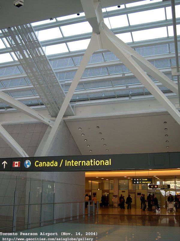
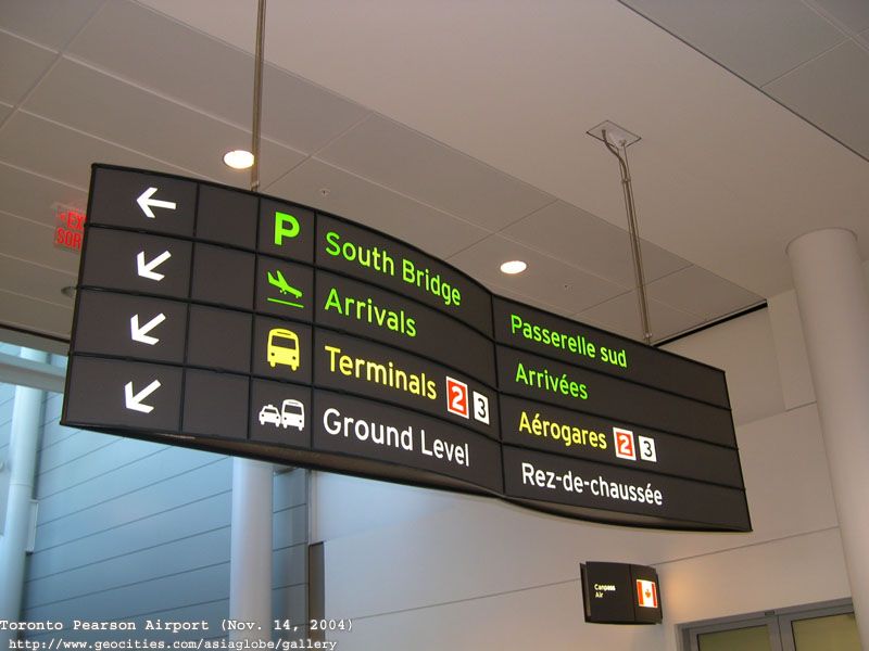
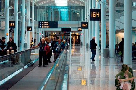
I'm a fan of the signs used at Pearson and I think that the TTC chould consider adopting it. The design is clean, simple and more importantly people can read it from a distance.

DSCN3761.jpg

DSCN3717.jpg

up-erin.jpg

AIN1218.jpg


The commission should also consider renaming the subway/LRT lines. Names like Eglinton Crosstown, Bloor-Danforth and Yonge-University-Spadina are a mouthful. I think that the best option would be changing the names to simple letters and numbers.

YUS becomes route A, represented by yellow.
BD become route B, represented by green.
Sheppard becomes route C, represented by purple.

Eglinton-Scarborough Crosstown LRT becomes route 1, represented by blue.
Sheppard LRT becomes route 2, represented by red.
Finch LRT becomes route 3, represented by brown.

I think this would be the best option. Especially when you consider that many people have no idea what the lines are actually called. I've lost count of the amount of times I've had to refer to our subway lines as "the green one", "the yellow u" and "that little purple one at the top".
I think that is ridiculous - numbers or letters. What, we are in grade one. You want to know when you get to a station or come off where you are - Yonge, Bloor, Danforth. Spadina is a lost cause because it does not run along any major street
 
It looks like the TTC has decided that the FWLRT and SELRT qualify rapid transit. They'll be on our subway/rt system map.

And I can't see any benefit to making the "non-rapid transit" parts distinctive. The travel time difference between them and "traditional" RT would be negligible. For example, with a hypothetical trip from Victoria Park to Kennedy on the ECLRT, the time difference of ROW LRT vs. underground LRT is ~120 seconds. I don't think very many people would notice the difference. This would just create poor optics leading to unneeded political tension.


The station spacing on the ROW part of the ECLRT is similar to that of the Bloor-Danforth. Hopefully this will be the same for FWLRT and SELRT when Metrolinx releases the details of the design of the lines. But if ML does keep the Transit City spacing, I agree that not all stations should be shown.

All stations should be shown, always. Stops, on the other hand...
 
The grade-separated portions of the line should be on the map, but the non-rapid-transit portions should be distintive. Also avoids listing all the at-grade stops and avoids the ridiculous scale on the east side of the map caused by the surface LRTs.

The scale isn't that ridiculous. On the Danforth the stop spacing is about 500-600m, on Yonge and University south of Bloor even closer together and there is no distinctive label (warning: stops may be closer than they appear). What benefit is the distinctiveness? I need to go to Eglinton and Warden and I see a thick filled line and a thick unfilled line. My trip will be different how? The lines change and might convince people they need to transfer or something but they don't... it is one route on the same equipment.
 

Back
Top