Toronto Ontario Line 3 | ?m | ?s | Metrolinx

Here's what I've come up with:

View attachment 276681

The space constraints in the western extension makes tunneling the best bet. Just after Stockyards, the line can elevate to the Kitchener Corridor and potentially have a station at Rogers Road, and then connect with Mount Dennis.
Interesting, although I see a subway up Dufferin or Bathurst much more likely in the long-term.
 
Has happened before. When they were designing Toronto's first rapid transit line, Yonge Street (Line 1), in the 1940's, they thought that the next rapid line would be the Queen streetcar-subway. Instead, their attention switched to Bloor Street and Danforth Avenue, in the 1950's. The ridership transfers at Bloor Station was getting higher, so they changed plans, to a Bloor-Danforth (Line 2), and even interline with three different lines. Wonder what "new" lines there would have been if they kept the three lines back then? Changes con

975px-TTCSubwayInterlined1966.svg.png

From link.

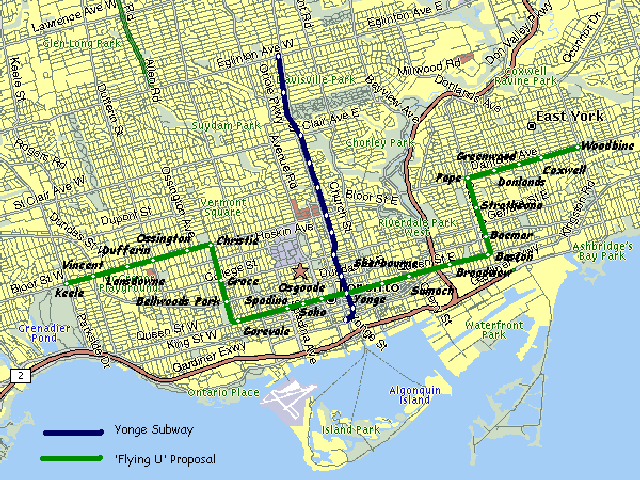
You also forget the intermediate flying U plan that would have been a full subway and created an awkward combination of the DRL/Queen and Bloor lines. Endless tinkering and really only building anything by virtue of occasional dumb luck is a long way from new here.
subway-5104-18.gif

I have to imagine that if this had been built the gap on Bloor would have been filled by now, and that we would most likely have ended up splitting the lines into something resembling the historical BD plus DRL at that time.
 
Has happened before. When they were designing Toronto's first rapid transit line, Yonge Street (Line 1), in the 1940's, they thought that the next rapid line would be the Queen streetcar-subway. Instead, their attention switched to Bloor Street and Danforth Avenue, in the 1950's. The ridership transfers at Bloor Station was getting higher, so they changed plans, to a Bloor-Danforth (Line 2), and even interline with three different lines. Wonder what "new" lines there would have been if they kept the three lines back then? Changes con


975px-TTCSubwayInterlined1966.svg.png

From link.
You also forget the intermediate flying U plan that would have been a full subway and created an awkward combination of the DRL/Queen and Bloor lines. Endless tinkering and really only building anything by virtue of occasional dumb luck is a long way from new here.
subway-5104-18.gif

I have to imagine that if this had been built the gap on Bloor would have been filled by now, and that we would most likely have ended up splitting the lines into something resembling the historical BD plus DRL at that time.

So, part of me wonders if there is any way to ... interline the Bloor and OL lines.

Think of it this way, every 2nd route goes through.
Route 1 Kennedy - Islington
Route 2 Ontario SC - Exhibition
Route 3 Kennedy - Exhibition
Route 4 Ontario SC - Islington

Would there be enough room to double the current Line 2 frequency?
Frequency and this plan are mutually exclusive. Based on the 4 routes, every station would still be service by the number of trains - except instead of all going to the same place, they alternate with final desitinations (i.e. Kennedy or SC, Islington or Ex).

Lot of difficulty connecting tracks though. Pape and Dundas West would be war zones of construction.
FYI - this was interesting back in the day. https://www.skyscrapercity.com/threads/trzs-drl-fantasy-13km-3-billion-former-toronto.670156/
 
Has happened before. When they were designing Toronto's first rapid transit line, Yonge Street (Line 1), in the 1940's, they thought that the next rapid line would be the Queen streetcar-subway. Instead, their attention switched to Bloor Street and Danforth Avenue, in the 1950's. The ridership transfers at Bloor Station was getting higher, so they changed plans, to a Bloor-Danforth (Line 2), and even interline with three different lines. Wonder what "new" lines there would have been if they kept the three lines back then? Changes con


975px-TTCSubwayInterlined1966.svg.png

From link.
This would have been required instead of the YUS. 4.5km of extra subway to keep the interline going.
Yonge-Bloor would not quite be the problem it is now though. I don't think anyone ever thought of this though - although possibly by Morse Code or Ham Radio some subway fans were discussing it.

1602720029751.png
 
I am trying to figure out westward, where this line could be extended. Does it go to the airport or does it head to Mississauga?

I'm not convinced that the line would have to go any farther than Roncesvalles/Queen in the near future with a stop at Jameson. That should be enough to serve Parkdale and Roncesvalles, thereby providing relief to the streetcar network. Further, it would provide an opportunity to re-orient transit in southern Etobicoke away from N/S bus routes, which, combined with GO service to Dundas West, should provide enough relief to Line 2 for the near future. If, as has been suggested upthread, we need a second relief line in a few decades, the Dundas corridor would seem like the most obvious route; I would therefore leave a Dundas West connection for that line.

The rest of this post probably belongs in the fantasy thread. In the future, I would like to see the OL extended farther west into Etobicoke. This would only work if we encouraged southern Etobicoke to further densify to the point that LW GO (including a Park Lawn stop) in no longer sufficient. My proposal would be to elevate the line over the Queensway to Humber Loop. Following this, it would curve down into the Humber Bay Shores community before continuing west, either under the Queensway or elevated over the Gardiner to Kipling. From Kipling, there would be a few options of where to go:

(1) Continue west to Sherway/Dixie GO
(2) Turn north up the former CP ROW up to Line 2 (with a Line 2 extension to Sherway/Dixie GO)
(3) Branch out in order to do both
(4) Branch both north and south along the CP ROW to Line 2 and Lake Shore/Humber College, respectively (perhaps with a third shuttle service running between Line 2 and Lake Shore)

Again, this would all hinge on major urbanization/densification of southern Etobicoke, not only of the Queensway corridor/HBS/Sherway areas, but also in the surrounding yellow belt neighbourhoods. Given its fairly regular street grid and handful of existing high streets, this should be much easier to accomplish than in most other suburban areas.
 
Frequency and this plan are mutually exclusive. Based on the 4 routes, every station would still be service by the number of trains - except instead of all going to the same place, they alternate with final desitinations (i.e. Kennedy or SC, Islington or Ex).

Lot of difficulty connecting tracks though. Pape and Dundas West would be war zones of construction.
FYI - this was interesting back in the day. https://www.skyscrapercity.com/threads/trzs-drl-fantasy-13km-3-billion-former-toronto.670156/

I have seen that before. That's kinda what I mean. I feel it would really be the only way to truly relieve Yonge-Bloor Station.

This would have been required instead of the YUS. 4.5km of extra subway to keep the interline going.
Yonge-Bloor would not quite be the problem it is now though. I don't think anyone ever thought of this though - although possibly by Morse Code or Ham Radio some subway fans were discussing it.

View attachment 276803

You mean a Bay-Bathurst-Avenue line?
 
I've got a technical theory about this, that doesn't revolve around Metrolinx's "it's faster" argument..... or my personal opinion which is that it's Ford's old ward and Associate Transport Minister Kinga Surma's current riding, and they're giving it "special treatment" as is completely typical with Ontario politicians of all political stripes.

I'll preface this by saying that I know Eglinton Avenue very very well. I've had many professional commitments and spent personal time in literally every segment of the road -- from spending time at a friend's place in one of those soul-sucking townhouses by the 407 at the Oakville border, to having drinks at the Olde Stone Cottage Pub at Kingston Road. I've seen every bit of the Crosstown and Mississauga BRT construction projects (at least, the Eglinton portion) evolve over the years with my own eyes.

I think there's a valid case that can be made related to residential noise.

Consider the existing Crosstown route::
  1. The overground segment from Kennedy to Leslie is almost 100% commercial or high-density residential. There are a small number of houses that back/overlook onto Eglinton around the Don Mills and Brentcliffe portals, and near Victoria Park Ave. A noise wall was built between the houses and the Brentcliffe portal before construction of the portal began in 2014 or whatever it was. They also just installed new noise walls between the site of Keelesdale Station's new bus terminal and some houses that are right beside it.
  2. The overground segment west of Keele is also not near any residential areas, except for a few houses beside Mount Dennis. The thing is, those houses are also directly beside the main train line, which includes UPX trains rumbling by every 7.5 minutes. I used to have a storage unit along the tracks a few blocks away from here.... it is indeed very noisy, all the time, so I suspect people in this specific area aren't going to complain about transit noise.
And Eglinton West LRT's design diagrams (PDF):
  1. The LRT would go back underground west of Mount Dennis, underneath the houses, avoiding putting the LRT route right outside people's front doors. The road here isn't wide enough for an LRT anyways; all the houses here have little to no front-yards.
  2. The route continues outdoors & elevated through the Scarlett Woods golf course area. No residences.
  3. The routes dives underground right around the point that the houses begin on the south side of Eglinton, west of Scarlett Road.
  4. From this point westward, especially west of Royal York, it's pretty much exclusively residential.
  5. West of Martin Grove, the houses thin out as it approaches the 427/401 interchange, but then there's a bunch more approaching Renforth. But at that point you do want to be underground again to facilitate a nice connection with the Mississauga BRT.
With all that in mind, I'll go so far as to say this: Putting Crosstown West overground would negatively impact many times more residences (and therefore people) than the Leslieville segment of the Ontario Line.

Do I personally think this is a justification for putting Crosstown West underground? Absolutely not, given the price. If you live right along Eglinton, you're already used to a ton of background noise from buses, cars, trucks, and airplanes.... and, like, boo-fuckin'-hoo, I've lived directly on three different streetcar routes in my life. It's a big city and sometimes that means big city noises.

But that's just my opinion. Other people are more sensitive to noise than me, and that is totally fair.
This is a great post. I don't agree with the residents' reasoning, but very well written.
Barring a rework of Transport Canada regs for through running with RER I tend to think the ideal is to end at Dundas West, with stations at King/Queen/Roncesvalles and (roughly) Roncesvalles and Howard Park.

Here's what I've come up with:

View attachment 276681

The space constraints in the western extension makes tunneling the best bet. Just after Stockyards, the line can elevate to the Kitchener Corridor and potentially have a station at Rogers Road, and then connect with Mount Dennis.
This is probably the best idea...and why it should be going along Queen street west and not all the way down at the Ex...
 
Why would Metrolinx be drilling OL core samples at Pape and Withrow, when core samples were drilled 10 metres south for the DRL? I don't believe the core samples would be different. I don't believe the soil has changed. Looks like a low cost make work project by Metrolinx to show the public it is doing something.
2020-10-16 09.31.38.jpg
2020-10-16 09.31.57.jpg
.
 
Why would Metrolinx be drilling OL core samples at Pape and Withrow, when core samples were drilled 10 metres south for the DRL? I don't believe the core samples would be different. I don't believe the soil has changed. Looks like a low cost make work project by Metrolinx to show the public it is doing something.
I believe core samples are only considered valid for 18 months typically. If the initial core samples are older than that, they may have to be redone.
 
Mind providing the link to the report? I too would like to read the public comments.
It's quite well hidden on ML's website! Took a little bit of digging to find it. Also the rest of the Environmental Conditions report (if anyone's interested) is here https://www.metrolinxengage.com/en/content/ontario-line-environmental-conditions-report
 
... and remember it's not Metrolinx that will be relying on the core samples, it's the proponents,
so for a relatively small cost, it's a cover your butt exercise as well in case the proponent does encounter a problem,
since tunnelling risk is typically transferred to the proponent.
 

Back
Top