News   Mar 27, 2024
 1.1K     1 
News   Mar 27, 2024
 1.1K     2 
News   Mar 27, 2024
 635     0 

Miscellany Toronto Photographs: Then and Now

I've forgotten more research than most Canadians will ever know.

Shall we start talking about you and your knowledge instead of Toronto's history?

And how we can sit in here and talk about buildings without discussing the businesses that pay for them (sorry, and taxpayers), and sometimes their silly ignorant administrations, is a bit strange.

I have a feeling there's something else you'd like to say but you'd rather just hint at it.
 
The insurance atlases generally showed things as they were, at least in terms of plots and properties. I've seen a few instances where they correspond to documented name changes, appearance/disappearance of streets, disconnections, extensions. There are a few indications of projected streets with dotted lines, which is not the case there. Since the map indicates one structure built on that lozenge-shaped block and it seems to account for the odd course of Lyndhurst/Wells Hill as it is now, I don't see a reason to consider it a plan rather than reality at the time. Or why they would have planned a short and oddly shaped street like Esten Rd without bothering to build it.

Update: the city has survey maps on its website, 'updated to June 2011', that actually list Esten Rd:

http://www.toronto.ca/mapping/catalogue/pdf/dmog_index.pdf
(see key sheet 21)

albeit as 'untravelled'.

Not only that, it's mentioned in reference to the EA for the St Clair line:

'Some sections of St. Clair Avenue require pavement
resurfacing. These include:
(...)
•Esten Road to Bathurst Street'
http://www.toronto.ca/wes/techservi...clair_w_transit/pdf/pcc1_project_displays.pdf

So maybe even if it no longer exists, it's still a reference point?!

Going to check it out tomorrow. Looks like there's some kind of path on the south side of St Clair W, opposite Tweedsmuir:
http://goo.gl/maps/YQkd
 
Wonderful 'show and tells' by mattelderca and Goldie. Thanks guys.

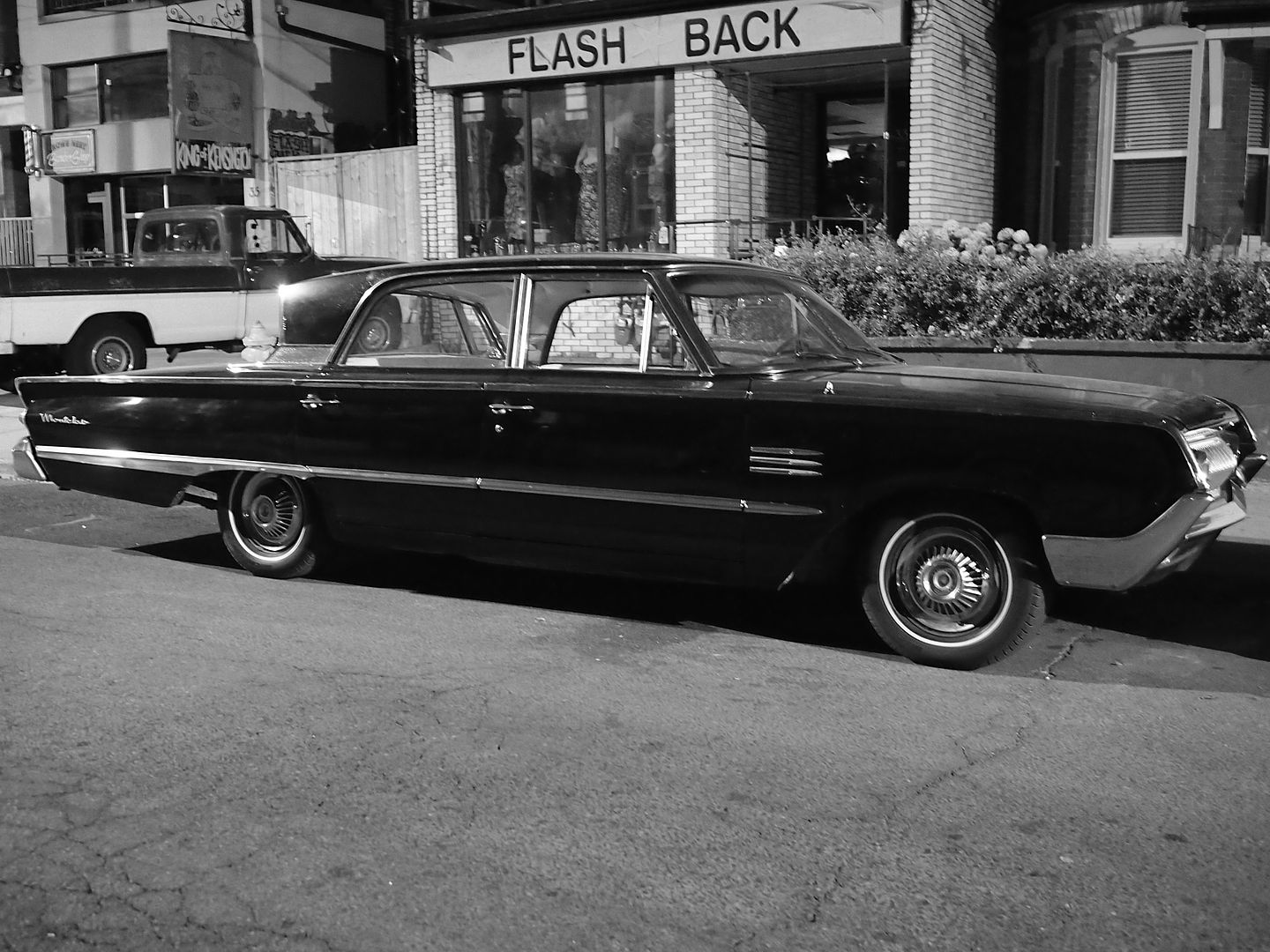
I couldn't find anything in my closet - just yet - but here's something old, a Mercury Montclair, parked in the older Toronto neighbourhood of Kensington Market.

This was taken this evening at 10pm. It looks like daytime because I was using a fast lens with lots of light gathering ability (shot at f2.5 and +01 EV). Note the sign on the store behind the car; what a coincidence. :)

P7140373.jpg

Awesome shot. Before reading your text I thought the picture was taken back in the day. Especially with the old pickup in the background.
 
Nice find

Wonderful 'show and tells' by mattelderca and Goldie. Thanks guys.

I couldn't find anything in my closet - just yet - but here's something old, a Mercury Montclair, parked in the older Toronto neighbourhood of Kensington Market.

This was taken this evening at 10pm. It looks like daytime because I was using a fast lens with lots of light gathering ability (shot at f2.5 and +01 EV). Note the sign on the store behind the car; what a coincidence. :)

P7140373.jpg

Mustapha, you saw it up close but, it appears it could be a 64 (Canadian) Meteor Montcalm. Same sheet metal as the Merc but Ford interior.
Toronto's Fire Chief cruised around town in a 2 door version back in the day.

Notice I had to "reverse" the archives photo...(they had it backwards)

tfd64meteor.jpg
 
Update: the city has survey maps on its website, 'updated to June 2011', that actually list Esten Rd:

http://www.toronto.ca/mapping/catalogue/pdf/dmog_index.pdf
(see key sheet 21)

albeit as 'untravelled'.

Not only that, it's mentioned in reference to the EA for the St Clair line:

'Some sections of St. Clair Avenue require pavement
resurfacing. These include:
(...)
•Esten Road to Bathurst Street'
http://www.toronto.ca/wes/techservi...clair_w_transit/pdf/pcc1_project_displays.pdf

So maybe even if it no longer exists, it's still a reference point?!

Going to check it out tomorrow. Looks like there's some kind of path on the south side of St Clair W, opposite Tweedsmuir:
http://goo.gl/maps/YQkd

Most fascinating. Even if there's nothing there, it's fascinating. Kind of like naming fantasy children who won't ever be born. The missus and I bandied about a name for a possible fourth child but that ain't happening now. :)
 
Awesome shot. Before reading your text I thought the picture was taken back in the day. Especially with the old pickup in the background.


Thanks hogdust. This vehicle was unrestored too. Original paint I think. The interior was original for sure. Quite neat, that..
 
Mustapha, you saw it up close but, it appears it could be a 64 (Canadian) Meteor Montcalm. Same sheet metal as the Merc but Ford interior.
Toronto's Fire Chief cruised around town in a 2 door version back in the day.

Notice I had to "reverse" the archives photo...(they had it backwards)

tfd64meteor.jpg


The Chief certainly moved around in style. What a great picture. Thanks for finding it for us. The red painted small chrome hub capped wheels really give a service vehicle/no nonsense purposefulness to the whole car.

The knife edge look of car design in the early 60s gave them great style. Cars nowadays all look like blobs.

Hudson8: it's sez 'Montclair' on the rear quarter of my subject car. I walked up to have a look and i.d it because I don't know a Lincoln from an Impala. :)
 
What a great rain storm today. Our city streets and sidewalks needed a good scouring like this.


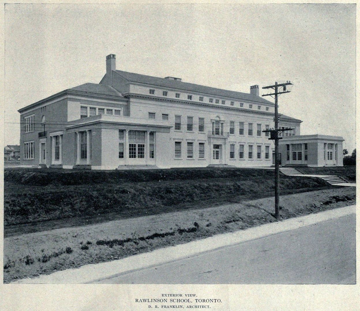
Then and Now for July 16.


Then. Rawlinson Public School. c1921. Earnscliffe and Glenholme Aves. I've been studying this one. It's not from the usual design mold. Other contemporary schools from the 1920s - Maurice Cody, John Wanless, Bedford Park schools all stylistically alike but this one was different. That roof; for starters.

669EarnscliffeNsideEofGlenholmec1921.jpg


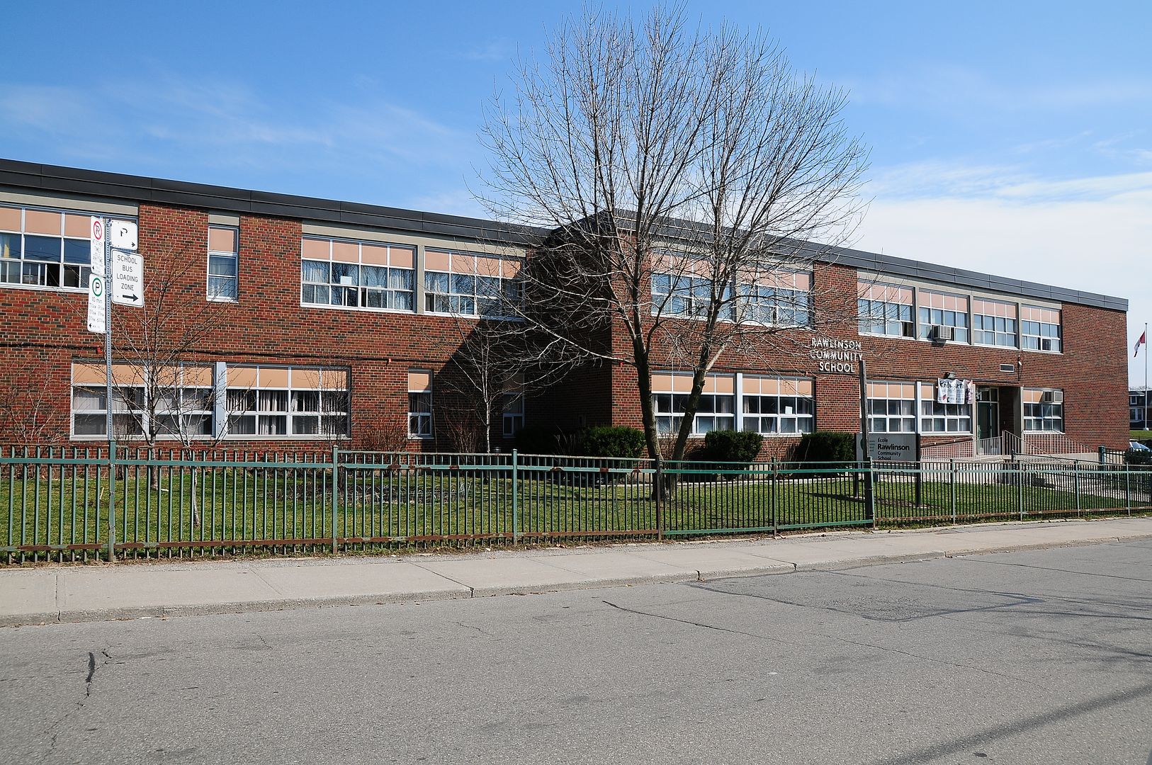
Now. April 2012. The original building might still be underneath that.. but then, probably not.

670.jpg
 
Awesome shot. Before reading your text I thought the picture was taken back in the day. Especially with the old pickup in the background.
.


Same here. Except that the pickup looks late 70s or early 80s, and that isn't "old". Is it?

I think I went into Flash Back four years ago when I was wandering the market, but I don't recall the King of Kensington sign. Is that a store or is it just a street banner?
 
Most fascinating. Even if there's nothing there, it's fascinating. Kind of like naming fantasy children who won't ever be born. The missus and I bandied about a name for a possible fourth child but that ain't happening now. :)

Thanks. Hard enough coming up with a name for just the one kid!

It was difficult to imagine Esten Rd having existed at all, given the topography of its apparent location (beside and behind a high-rise), but the lost part of Russell Hill Dr seemed like it could have fit in the present Nordheimer ravine, with the street enclosing the stream that's there. I suppose construction of the subway (and its emergency services entrance) altered the grade level quite a bit.

I have no idea what the purpose of those survey maps is, but among them is one marking 'Royal Drive', which I believe came up a while ago. It appears to be the DVP onramp at Broadview now.
 

Back
Top