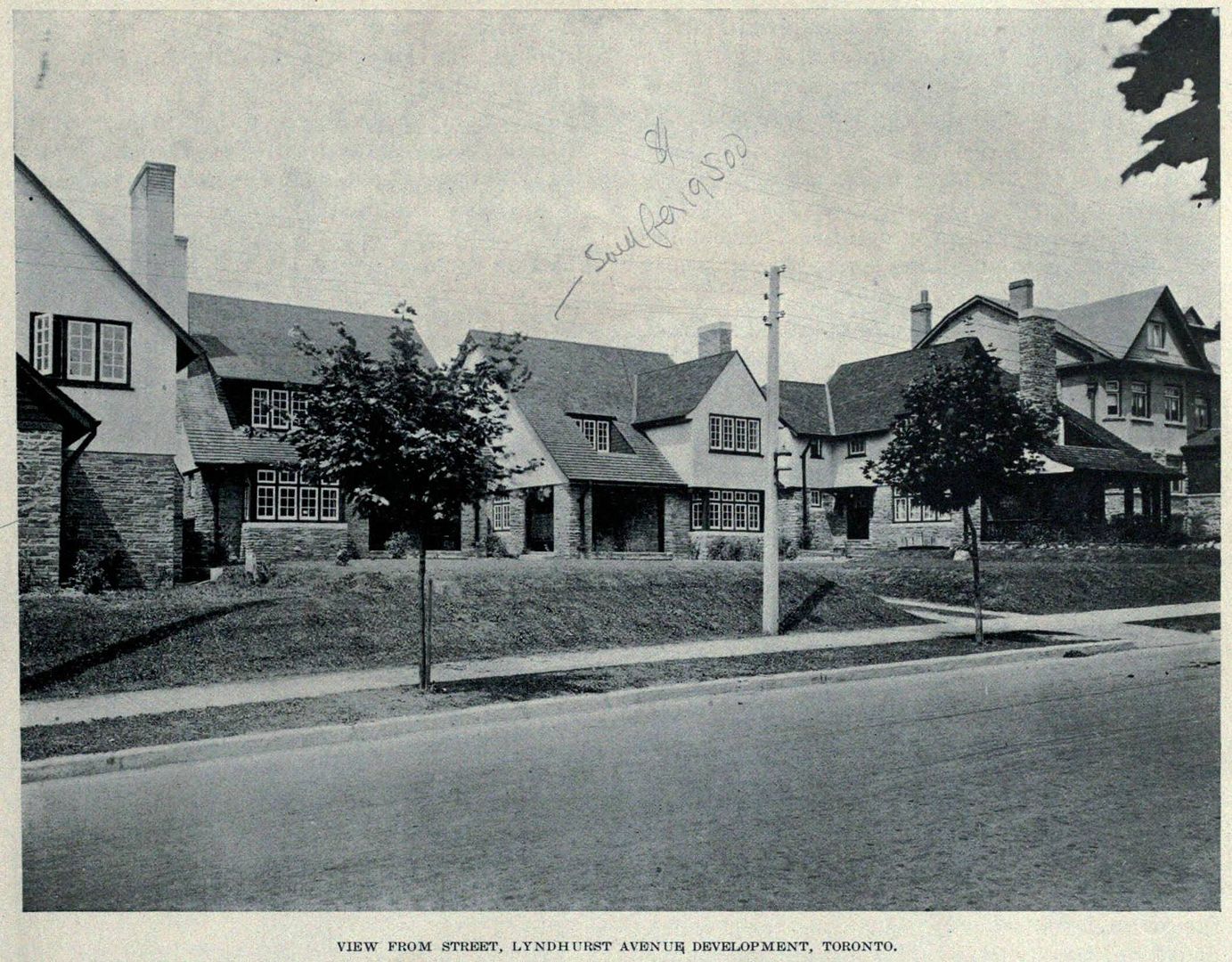
News   Apr 26, 2024
 1.6K     4 
News   Apr 26, 2024
 352     0 
News   Apr 26, 2024
 914     1 

Miscellany Toronto Photographs: Then and Now

Was at the intersection of Weston Road and Sheppard Avenue West yesterday and noticed a new housing community and I could have sworn there used to be a plaza there. Perhaps I am wrong but does anyone have pics of what used to be there before the community now known as Westown.

No idea what the facility was, but from Google Earth's historical images it looks more like a warehouse or factory than a shopping plaza (very little parking for cars and lots of transport trucks)

From Google Earth's images, I make the following observations
-The site originally held three buildings on two properties. Not certain what the north property was, but the southern one was King Koil (mattresses) and Bedford furniture. The sign is still up in the Google streetview

https://maps.google.ca/maps?hl=en&l...=l0CK7A-Zrr0qxWp6Xnd-6g&cbp=12,353.23,,1,1.79

-The large northern and small central buildings look like they're in use in 2002, but closed down in the following year or two. The King Koil remains in use for a few more years.
-By 2005 the small central building has been demolished
-The entire site has been leveled by the fall of 2007
 
Well, IIRC most if not all of it may have started as a factory/warehouse/distribution centre, but by the 80s, at least, much of it had become what was ultimately No Frills, Zellers (?), and little or anything else...
 
Then and Now for July 9.


Then. c1920. W side of Lyndhurst, looking NW from just N of Austin Terrace.

661LyndhurstWsideNfromAustinc1920.jpg


Now. March 2012.

662.jpg


And, a couple more as a bonus. Not quite the same angle; I didn't feel it was appropriate to intrude on their 'space' by hopping a fence and standing on their lawn.

659LyndhurstNfromAustinTerraceWsidec1920.jpg


660.jpg
 
Those maps sometimes reflected just plans and not reality. It probably wasn't eliminated - it never existed.

The insurance atlases generally showed things as they were, at least in terms of plots and properties. I've seen a few instances where they correspond to documented name changes, appearance/disappearance of streets, disconnections, extensions. There are a few indications of projected streets with dotted lines, which is not the case there. Since the map indicates one structure built on that lozenge-shaped block and it seems to account for the odd course of Lyndhurst/Wells Hill as it is now, I don't see a reason to consider it a plan rather than reality at the time. Or why they would have planned a short and oddly shaped street like Esten Rd without bothering to build it.
 
The insurance atlases generally showed things as they were, at least in terms of plots and properties. I've seen a few instances where they correspond to documented name changes, appearance/disappearance of streets, disconnections, extensions. There are a few indications of projected streets with dotted lines, which is not the case there. Since the map indicates one structure built on that lozenge-shaped block and it seems to account for the odd course of Lyndhurst/Wells Hill as it is now, I don't see a reason to consider it a plan rather than reality at the time. Or why they would have planned a short and oddly shaped street like Esten Rd without bothering to build it.

I was going from the 1924 map of north Leaside - the streets all have names - they aren't dotted lines - but they are a lot different from what was actually built. I assumed the map was based on the plans of subdivision #1908 and #1925, and by the time the area was actually developed in the 1940s the plans had changed.


Leaside1924.jpg

That's also possible (it looks like that atlas has addenda pasted in), but there's 'planned vs actually built' and then there's 'built and then rebuilt'. What did it look like in the 1940s?

Was Leaside planned as mostly residential but ultimately built with commercial, industrial and institutional additions? I'm thinking specifically of the effect on the roads in Leaside caused by industry east of Laird, the creation of Leaside High (1945) and Sunnybrook (1948).

I guess looking in the city archives is one way of seeing if certain streets actually ran as they appeared in the atlases.
 
That's also possible (it looks like that atlas has addenda pasted in), but there's 'planned vs actually built' and then there's 'built and then rebuilt'. What did it look like in the 1940s?

Like fields.
Here's a 1942 aerial photo of Leaside - unfortunately mostly south of Eglinton but you can see there wasn't much north of Eglinton.

380px-TorontoLeasideAerial1942.jpg


The photo comes from Wikipedia which explains the history of the development of Leaside better than I can.
http://en.wikipedia.org/wiki/Leaside

And here's a 1947 aerial photo of the of the area to the east - with Goldie's notes. Doncrest and the other streets northeast of Eglinton & Brentcliffe (Brentwood) on the 1924 Goad's don't exist, and the houses east of Laird on Donlea, Divadale, and Don Avon are in the process of being built.
Leasideaerial1947-notations.jpg
 
Hi Goldie. What ever happened to the Leaside Aerodrome dig you , Mustapha and I were going to do in the spring? Got my shovel at the ready.
 
Guess I'm all talk and no action!
When do you want to meet?
Location should be Wicksteed at rail crossing.
I'm available anytime.
 

Back
Top