


JasonParis
Moderator
I'm lifting this from the Spacing Wire. It's Matthew Blackett's ideas for new TTC maps and I figured it's a worthy idea so let's get on Adam's case about this!
I've posted the maps full size in the next entry as they are quite large. There's also lots of comments if you follow the Spacing link, so please do!
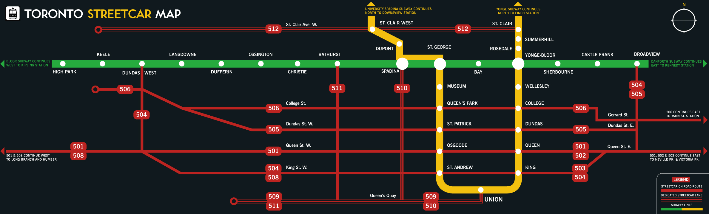
Streetcar Map for Toronto
About a year ago I sat down with TTC Chair Adam Giambrone and his staff to discuss a number of little ideas I had percolating in the back of my head. One of my suggestions was to create an iconic streetcar map. Not much groundwork has been made on this idea so I’m taking it public.
I’ve always found it perplexing that while travelling on a streetcar you have no idea of which subway stations have streetcars routes passing through or which streetcar routes intersect with one another. My idea is to place the streetcar maps above the rear exit of streetcars, much like subway maps appear above entrance/exit doors on trains.
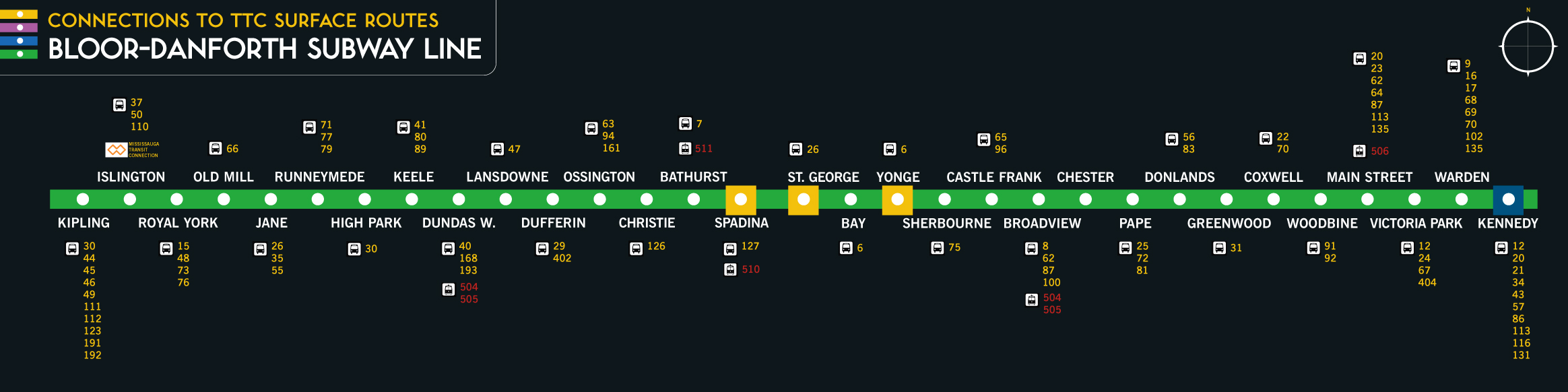
The second map I created is for subway riders to see which bus and streetcar routes intersect with subway stations (I’ve used the Bloor-Danforth subway line as my example).
The reason behind this is simple: while on a subway, riders do not have access to any information that would show them where these routes exist (or bus routes for that matter). There are occasions when people change their route mid-trip and need to figure out how to get somewhere. Currently, they would have to get off the subway and make their way up to the fare box area and look at the TTC’s system-wide map. This map would alleviate that excursion all together.
In essence, the below-ground and above-ground transit systems do not “speak” to one another leaving less-knowledgeable riders to make guesses that cost them time, as well as make their trip less efficient and much more frustrating. Often out-of-town tourists and riders from Toronto’s suburbs are intimidated by the TTC’s transit system and need all the help they can get navigating. As well, the streetcars are an iconic symbol for Toronto and we need the TTC to treat the Red Rockets as such. Creating an iconic map would be a good first step.
I am looking for constructive feedback from Spacing readers so that I can refine these maps and officially submit them to the TTC in February and be dealt with at the Commissioners’ meeting in March. My goal is to help make riding the streetcar and subway much easier and I believe these two maps can address some of these concerns.
I've posted the maps full size in the next entry as they are quite large. There's also lots of comments if you follow the Spacing link, so please do!
Streetcar Map for Toronto
About a year ago I sat down with TTC Chair Adam Giambrone and his staff to discuss a number of little ideas I had percolating in the back of my head. One of my suggestions was to create an iconic streetcar map. Not much groundwork has been made on this idea so I’m taking it public.
I’ve always found it perplexing that while travelling on a streetcar you have no idea of which subway stations have streetcars routes passing through or which streetcar routes intersect with one another. My idea is to place the streetcar maps above the rear exit of streetcars, much like subway maps appear above entrance/exit doors on trains.
The second map I created is for subway riders to see which bus and streetcar routes intersect with subway stations (I’ve used the Bloor-Danforth subway line as my example).
The reason behind this is simple: while on a subway, riders do not have access to any information that would show them where these routes exist (or bus routes for that matter). There are occasions when people change their route mid-trip and need to figure out how to get somewhere. Currently, they would have to get off the subway and make their way up to the fare box area and look at the TTC’s system-wide map. This map would alleviate that excursion all together.
In essence, the below-ground and above-ground transit systems do not “speak” to one another leaving less-knowledgeable riders to make guesses that cost them time, as well as make their trip less efficient and much more frustrating. Often out-of-town tourists and riders from Toronto’s suburbs are intimidated by the TTC’s transit system and need all the help they can get navigating. As well, the streetcars are an iconic symbol for Toronto and we need the TTC to treat the Red Rockets as such. Creating an iconic map would be a good first step.
I am looking for constructive feedback from Spacing readers so that I can refine these maps and officially submit them to the TTC in February and be dealt with at the Commissioners’ meeting in March. My goal is to help make riding the streetcar and subway much easier and I believe these two maps can address some of these concerns.