News   Jan 10, 2025
 2.4K     7 
News   Jan 10, 2025
 1.6K     1 
News   Jan 10, 2025
 661     0 

YRT/Viva Construction Thread (Rapidways, Terminals)

I think reconstructing the intersection is the only solution here and it doesn't even have to be much. To obtain more space, the northbound left turn lane can be closed and traffic can turn one light earlier at Hopkins Street with a new traffic signal added at Atkinson Street to turn onto Major Mackenzie Drive. This would allow for a single pedestrian path on the east side of the lanes in the median to be built. Southbound passengers can cross the bus lanes from a pedestrian crossing at the north of the station, where busses will yield.
View attachment 301239
it would make sense if the station was farther north, closer to MM than currently, but considering that the stop is pretty much at the intersection as you have illuistrated, ther distance and time required to get from MM to the stop is pretty much tyhe same for both cases.
I would suppose its now just a matter of conditioning the mind to realise that it will take similar time to get to the stop the correct way than to jaywalk to the stop from the top.
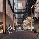
 
That sounds like an easy way to have everyone in Richmond Hill turn against you and tear you to shreds. I feel like the reason why the stop is built as it is is because I think they want to leave room for a potential underground tunnel under Richmond Hill Centre. A lot of older renders seem to consider this as a possibility:
View attachment 301240
Yeah no. That was a complete joke, even more so than Brampton’s laughable LRT tunnel. And besides, even if a tunnel were to be built in 30 years, moving a stop like that is basically a nothing cost in a ~1.3 km tunnel project. And in the meantime, every single person who transfers at that intersection has to waste 5 mins walking 200m for no good reason.

There is no justification for this incredibly dumb stop location. Making a horrible 200m transfer at a corridor where there are two important bus connections today and is literally planned to become a major transfer point to other BRT services in the future is completely asinine. It’s almost like if we deleted Warden/Golden Mile station on ECLRT and saying “yeah but you can get off at Hakimi-Lebovic.”

I suspect the reason is because there’s no space in the current ROW to widen the road north of Major Mack, and the government doesn’t have the guts to expropriate a few properties and would rather have transferring transit users walk 200m for no reason since NIMBYs will go crazy and transit is for poor people and broke students anyways. I mean, what can you expect from York Region... (Slightly joking, but seriously, this is horrible)
 
That sounds like an easy way to have everyone in Richmond Hill turn against you and tear you to shreds. I feel like the reason why the stop is built as it is is because I think they want to leave room for a potential underground tunnel under Richmond Hill Centre. A lot of older renders seem to consider this as a possibility:
View attachment 301240
I don't think the suggestion is that controversial. It's not like I'm suggesting to remove left turns from the entire corridor and require U-turns.

I always thought that render was of Yonge and Highway 7, not Major Mackenzie.
 
I don't think the suggestion is that controversial. It's not like I'm suggesting to remove left turns from the entire corridor and require U-turns.

I always thought that render was of Yonge and Highway 7, not Major Mackenzie.
Well first, Highway 7 and Yonge don't ever directly intersect, but 2nd in the original document its from, I believe its labelled as "Yonge Street Facing North". The rapidway terminates at RHC, so this can't be viewing south of Highway 7 since the expectation is that south of Highway 7, rapid transit will be service by Yonge North. The only other logical place this could be is Major Mackenzie as a way to go under downtown Richmond Hill.
 
That sounds like an easy way to have everyone in Richmond Hill turn against you and tear you to shreds. I feel like the reason why the stop is built as it is is because I think they want to leave room for a potential underground tunnel under Richmond Hill Centre. A lot of older renders seem to consider this as a possibility:
View attachment 301240

Let's hope that when they build a tunnel it is for an LRT, bit BRT. Otherwise you will end up wiht he mess Ottawa has as they convert their Transitways.
 
Yeah no. That was a complete joke, even more so than Brampton’s laughable LRT tunnel. And besides, even if a tunnel were to be built in 30 years, moving a stop like that is basically a nothing cost in a ~1.3 km tunnel project. And in the meantime, every single person who transfers at that intersection has to waste 5 mins walking 200m for no good reason.

There is no justification for this incredibly dumb stop location. Making a horrible 200m transfer at a corridor where there are two important bus connections today and is literally planned to become a major transfer point to other BRT services in the future is completely asinine. It’s almost like if we deleted Warden/Golden Mile station on ECLRT and saying “yeah but you can get off at Hakimi-Lebovic.”

I suspect the reason is because there’s no space in the current ROW to widen the road north of Major Mack, and the government doesn’t have the guts to expropriate a few properties and would rather have transferring transit users walk 200m for no reason since NIMBYs will go crazy and transit is for poor people and broke students anyways. I mean, what can you expect from York Region... (Slightly joking, but seriously, this is horrible)
The problem is that because the area north of Major Mackenzie is part of the historic downtown, expropriation might be nigh impossible due to the heritage status and the buildings being labelled historic. Regardless, there is no way any government in their right mind could get away with expropriating all of this:
 
Well first, Highway 7 and Yonge don't ever directly intersect, but 2nd in the original document its from, I believe its labelled as "Yonge Street Facing North". The rapidway terminates at RHC, so this can't be viewing south of Highway 7 since the expectation is that south of Highway 7, rapid transit will be service by Yonge North. The only other logical place this could be is Major Mackenzie as a way to go under downtown Richmond Hill.
Well, that tunnel entrance is probably not on Highway 7 nor Yonge, but on the connector between them. (p.105 of the Yonge Subway Extension Conceptual Design Report)
Screen Shot 2021-02-22 at 9.54.15 AM.png
 
When the Big Move was being prepare to be written, various meetings where held around the GTA for members of levels of local governments' at different time. I was asked to set in to help a few areas and one of them was Richmond Hill and the other was Markham.

At one meeting while sitting with the RH folks, we got taking about what RH wanted and looking down the road at that we talked about Yonge St. The RH folks saw a tunnel going under the Town downtown starting around Major Mack to the south and ending north at a number of locations for BRT that could be upgraded to LRT at some future date back in 2007/8.

They saw the need only for an BRT on Yonge and Major Mack as well not seeing a subway from Toronto. The region on the other hand saw a subway. RH saw more bus routes with beef up service and express service.

We looked at various things pertaining to RH downtown and it was quite clear it was a major pinching point for everyone that servicing transit would take a major hit down the road and why there was a need for a tunnel under it. There was a mix view about the tunnel as some saw it only for transit while others wanted a mix tunnel to carry through traffic to reduce the traffic to more local needs. In the end, the recommendation was for an BRT/LRT tunnel along with various transit improvements.

Markham was pushing for LRT highway 7 as well to Mississauga by 2 different routes with one connecting to Mississauga Transitway. Markham was very split on what it saw for its needs, but did accept the highway 7 BRT plan that could be upgraded to LRT at some future date. They also supported the subway into York Region from Toronto to help cover the cost of building things in York Region since they could cover the cost of building things down the road.

My view for a mix tunnel that it would have to be 4/6 lane wide and very deep to get under all the structures that it has legs, but need to be wider for stations.
 
Last edited:
When the Big Move was being prepare to be written, various meetings where held around the GTA for members of levels of local governments' at different time. I was asked to set in to help a few areas and one of them was Richmond Hill and the other was Markham.

At one meeting while sitting with the RH folks, we got taking about what RH wanted and looking down the road at that we talked about Yonge St. The RH folks saw a tunnel going under the Town downtown starting around Major Mack to the south and ending north at a number of locations for BRT that could be upgraded to LRT at some future date back in 2007/8.

They saw the need only for an BRT on Yonge and Major Mack as well not seeing a subway from Toronto. The region on the other hand saw a subway. RH saw more bus routes with beef up service and express service.

We looked at various things pertaining to RH downtown and it was quite clear it was a major pinching point for everyone that servicing transit would take a major hit down the road and why there was a need for a tunnel under it. There was a mix view about the tunnel as some saw it only for transit while others wanted a mix tunnel to carry through traffic to reduce the traffic to more local needs. In the end, the recommendation was for an BRT/LRT tunnel along with various transit improvements.

Markham was pushing for LRT highway 7 as well to Mississauga by 2 different routes with one connecting to Mississauga Transitway. Markham was very split on what it saw for its needs, but did accept the highway 7 BRT plan that could be upgraded to LRT at some future date. They also supported the subway into York Region from Toronto to help cover the cost of building things in York Region since they could cover the cost of building things down the road.

My view for a mix tunnel that it would have to be 4/6 lane wide and very deep to get under all the structures that it has legs, but need to be wider for stations.
Interesting to read.

At least in the current state though, is a tunnel under downtown a future possibility or is it not being discussed at all?
 
Interesting to read.

At least in the current state though, is a tunnel under downtown a future possibility or is it not being discussed at all?
The idea of the tunnel was around long before the Big Move. I have no idea where the idea of the tunnel is at this time as it out of my area these days. From a transit point, it needs to happen.
 
The problem is that because the area north of Major Mackenzie is part of the historic downtown, expropriation might be nigh impossible due to the heritage status and the buildings being labelled historic. Regardless, there is no way any government in their right mind could get away with expropriating all of this:
No, I'm not saying they should have expropriated all of Downtown Richmond Hill to put in bus lanes. That would be ridiculous. All that needs to be done to make Major Mack station at Major Mack instead of 200m away is to have the buses merge into Yonge St. north of Major Mack instead of south of it. That way, there's room for the station at Major Mack. (Basically, it's just copying 19th-Gamble station).

Approximate expropriation required:
- slivers of maybe a dozen properties
- 2-3 buildings demolished/relocated
1614310220130.png
 
No, I'm not saying they should have expropriated all of Downtown Richmond Hill to put in bus lanes. That would be ridiculous. All that needs to be done to make Major Mack station at Major Mack instead of 200m away is to have the buses merge into Yonge St. north of Major Mack instead of south of it. That way, there's room for the station at Major Mack. (Basically, it's just copying 19th-Gamble station).

Approximate expropriation required:
- slivers of maybe a dozen properties
- 2-3 buildings demolished/relocated
View attachment 302071
There are probably a lot of issues relating to heritage status there in terms of that plan.
 
There are probably a lot of issues relating to heritage status there in terms of that plan.
Heritage buildings can be moved. Even in Newmarket on Davis Dr they actually moved a heritage house to make way for the BRT to nowhere. Heck, even the massive Kodak building got moved for Mount Dennis on Eglinton.That’s why I said “demolished or relocated”. Probably not cheap, but 100% worth it. At least better than spending millions to make transit worse for a significant number of riders.
 
Heritage buildings can be moved. Even in Newmarket on Davis Dr they actually moved a heritage house to make way for the BRT to nowhere. Heck, even the massive Kodak building got moved for Mount Dennis on Eglinton.That’s why I said “demolished or relocated”. Probably not cheap, but 100% worth it. At least better than spending millions to make transit worse for a significant number of riders.
It's different though... you're asking them to relocate not only an almost 200 year old building, but also its cemetery. Not to mention if you've every been there its not level grade; there's a mini embankment right at the intersection. So not only will you have to move the building and graves, you'll have to spend extra bucks leveling the land.
 
There are probably a lot of issues relating to heritage status there in terms of that plan.
Heritage buildings can be moved. Even in Newmarket on Davis Dr they actually moved a heritage house to make way for the BRT to nowhere. Heck, even the massive Kodak building got moved for Mount Dennis on Eglinton.That’s why I said “demolished or relocated”. Probably not cheap, but 100% worth it. At least better than spending millions to make transit worse for a significant number of riders.

Sche is closer to correct here.

Lets just look at the Streetview for the area of Yonge immediate north of Major Mack on the east side.

1614313227297.png


There is only 1 building in this photo; I don't know if its heritage, can't say it looks the part; but there's nothing else there, and the building wouldn't have to be touched anyway, just an already molested frontage eaten into a tiny bit.

****

The same could really be said of the west side too.

1614313383834.png


Though I'll concede that the landscaping and retaining wall closer to Major Mack are attractive.

The wall could be rebuilt slightly further back at no loss.

To lose the trees would be unfortunate, and might be avoidable if the east side if fully utilized for net new space; but certainly could be considered.

****

On the south side of Major Mack, the south-west corner looks plenty roomy:

1614313564222.png


While the west side has only one building that might be heritage:

1614313648823.png


And it seems to have lots of room behind it to shift it, if desired:

1614313694633.png
 

Back
Top