Toronto Ontario Line 3 | ?m | ?s | Metrolinx

I don't really see the point of a subway underneath King with the rail corridor so closeby. If SmartTrack is happening, the next logical place for a east-west downtown subway is Queen Street.


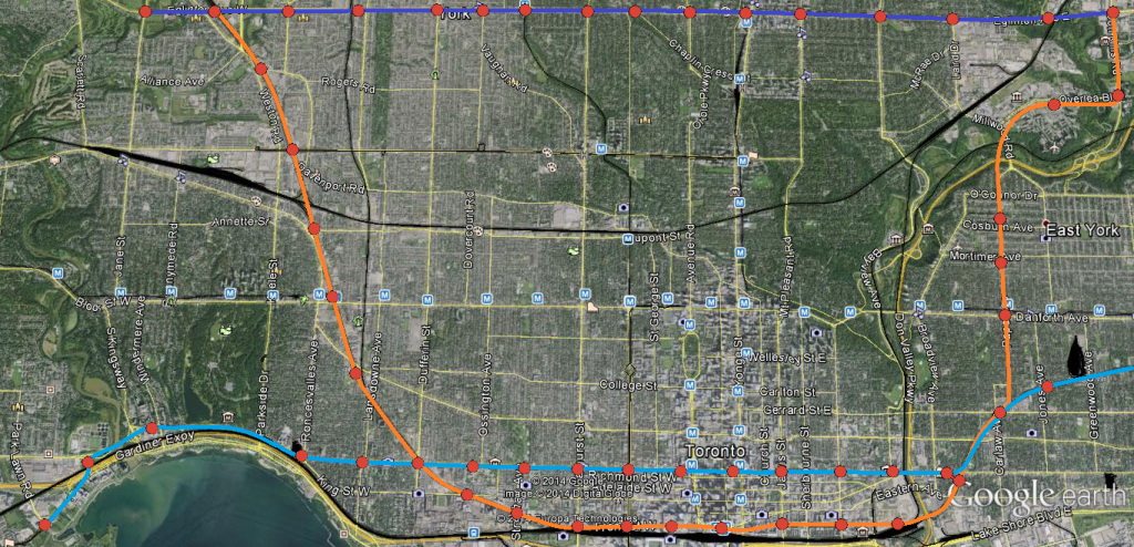
In a perfect world, we would be building something like this:


As I said before, if we're building SmartTrack (cyan) as complimentary to a true DRL (orange); have the second subway line travel across the central core west to the developments along the Humber Bay area. Think of all the nodes/trip generators within easy walking distance of Queen (Chinatown, Queen West, CAMH lands, Parkdale, SoHo, Eaton Centre, City Hall, Regent Park) that'd be so much harder to access if the alignment were King.

Meanwhile a DRL following the rail corridors, the Esplanade and Front St W would allow for easy walking distance access to: Unilever, West Don Lands, the Distillery District, St Lawrence, Union Station, CN Tower/Ripley's/Skydome, CityPlace, Liberty Village. A King alignment only has a more direct connection to the Financial District going for it, so in my opinion dual subway lines through the core are of more benefit than trying to force everyone onto King.

I like the general concept, however, I'm not sure how feasible the station frequency you have illustrated on the rail corridor is, in particular the track bottleneck between the Don River and Pape.

Space in rail corridors need to be reserved to run regional rail services. When multiple GO lines merge, in addition to whatever other VIA or HSR servicis running on the same rail corridor that corridor is going to become very constrained and won't have enough room for infill stations. The 800m Metro-type spacing you've illustrated won't really be all that feasible south of Bloor. Subways need more frequent spacing, thereby making subway alignments under arterial roads where the people are more appropriate. (It's kind of difficult to intensify on top of an active rail corridor.)

To help illustrate this, below is a cutaway from a fantasy map I've been working on.

D8i032A.png


(Aside: the teal line is this map is re-purposing the UPX ROW for local service. Actual express service between Union and Pearson would continue to operate on regular GO track)
 
Last edited:
I love the DRL and believe to be this city’s biggest priority. IMO the more stations built downtown, the better. But I think people need to start being more realistic with what can be built. As it stands Toronto’s transit priorities are: Scarb Subway ($4bn); FWLRT, SELRT, Crosstown East ($4bn?); Yonge North ($2.5bn?); East Bayfront ($0.5bn); SmartTrack ($7bn).

As well as putting the finishing touches on the Crosstown ($4.5bn), Spadina Extension ($2.5bn), Union (~$1bn), and UPX (~$1bn). And let’s not forget the +$Billion for things like SOG, fleets, second entrances/accessibility, and bus/streetcar facilities. There’s no denying these amounts are significant, particularly for a city of a mere 2.7M. Eglinton alone is considered to be one of the world’s costliest rapid transit projects.

Added into all of this is an $8.5bn DRL which, according to many here (including myself), is our biggest priority. Something’s gotta give. Although I’m waiting with bated breath for the next DRL report, I think it’s safe to say that the prognosis won’t be good.

While many posters are concerned with connecting places like Pape Village and Flemingdon to a rapid transit-style subway line, I think it’s safe to say that Toronto will be lucky to get anything connecting King and Pape by 2040 – all things considered. Either that, or some plan which uses the Metrolinx-owned Don Branch. Not as part of whatever idea I or others cooked up, but rather a low-rate, no-stop shuttle between Leslie/Eglinton and Union. And frankly, the most critical part of the DRL isn't even about relieving Yonge - it's the tunnel along King/Queen through downtown. IMO at least.

Below is a cutaway from a fantasy map I've been working on to help illustrate this point.

Oh shit, I like this. Particularly your use of bold, retro-ish Network 2011-style colours. As well as connecting the Port Lands. Edit: I also notice you put to use the Don Branch...I'm intrigued.
 
Last edited:
Back on topic...

NcOs7xx.png


King-Pape alignment. End it at Roncesvalles, have it serve the Portlands.
Interchanges with GO RER (or Smarttrack, whatever) at Roncesvalles, Shaw, and Gerrard

Routing the line to the Portlands makes a convenient extraction point for TBMs, and would also act as a catalyst for development of the surrounding brownfield.
Yes, that's generally what we need. Some minor quibbles - I'd put the station at Bathurst, instead of a couple of blocks west. And I'd think about diving even further south into the Portlands with a station at Commissioners (maybe 2 stations, one in the Lever lands, and one down on Commisioners street).

But generally, this is exactly what we need.

I don't really see the point of a subway underneath King with the rail corridor so closeby. If SmartTrack is happening, the next logical place for a east-west downtown subway is Queen Street.
Whether be King, Wellington, Queen, Richmond, Adelaide, or Dundas should be determined based on the results of the modelling to indicate which locations best relieves Bloor-Yonge station. Though I fear going further north, would leave the SmartTrack unable to provide much good east-west service, unless it was tunelled in it's own right-of-way under the rail corridor.
 
Last edited:
To help illustrate this, below is a cutaway from a fantasy map I've been working on.

D8i032A.png


(Aside: the teal line is this map is re-purposing the UPX ROW for local service. Actual express service between Union and Pearson would continue to operate on regular GO track)

I don't get abolishing the Kingston Road streetcar while extending the 506 to Victoria Park. This just seems to make things even worse for people in the beaches, which I didn't think possible.
 
...by building a bridge.
Or a tunnel. I just don't see the issue. Subways in difficult soil conditions are nothing new. If the tube in London can cross the Thames 14 times surely Toronto can manage another crossing of the Don.
 
I don't get abolishing the Kingston Road streetcar while extending the 506 to Victoria Park. This just seems to make things even worse for people in the beaches, which I didn't think possible.
That isn't the biggest problem this plan has in the east end. It removes the subway/GO connection from Main Street/Danforth, by moving Danforth GO station from Main to Warden - despite the density that has grown up around Danforth station.
 
King-Pape alignment. End it at Roncesvalles, have it serve the Portlands.
Interchanges with GO RER (or Smarttrack, whatever) at Roncesvalles, Shaw, and Gerrard

Routing the line to the Portlands makes a convenient extraction point for TBMs, and would also act as a catalyst for development of the surrounding brownfield.

I'm a huge fan of any DRL alignment that reaches Sunnyside.

Sunnyside can become a transit hub with the DRL, GO RER, WWLRT and Queen streetcar all connecting there.

I'd be in favour of this. In the west, you could build a streetcar line along the Queensway, with that route and the Lakeshore West route overlapping on the ROW section, terminating at Roncesvalles. In the east, swinging the DRL south opens up the possibility of locating the DRL yard in the Portlands without the need for a giant non-revenue connecting track.
 
The DRL isn't going anywhere. It's not dead but has been put on the backburner until SmartTrack is up and running.

I think this is great because SmartTrack can still work as a DRL but at the same time serve dozens of new destinations and hundreds of thousands more people than a DRL will. The DRL will also take forever to build and Torontonians are tired of waiting, They need rapid transit and they need it ASAP and a DRL doesn't offer that.

This is exactly the reason why I think the DRL will be merged into "SmartTrack Phase 2", or something like that. Run Phase 1 into Union because it's much less expensive and much quicker. Meanwhile, do the studies and everything for the DRL tunnel. When that tunnel is complete, switch SmartTrack to using that, and open up the freed up slots at Union for expanded 905 GO RER service.
 
That isn't the biggest problem this plan has in the east end. It removes the subway/GO connection from Main Street/Danforth, by moving Danforth GO station from Main to Warden - despite the density that has grown up around Danforth station.

I noticed that too but it seems the plan is to get people to take the 506 to Vic Park and then an express train downtown? Or over to Gerrard Square? I'm not sure I'd want to rely on the 506 of all routes... I just focused on the 502/503 because I don't know why you would abandon that much track. Is service on Queen between McCaul and Kingston going to be cut (due to the removal of overlapping routes), or are all the additional 501s going to Neville Park? Or maybe up Coxwell?
 
That isn't the biggest problem this plan has in the east end. It removes the subway/GO connection from Main Street/Danforth, by moving Danforth GO station from Main to Warden - despite the density that has grown up around Danforth station.

Did the high-density cluster actually grow up around the GO station or was it the terminus of the subway? Regardless, Main could perhaps still use a station on the teal line.

I don't get abolishing the Kingston Road streetcar while extending the 506 to Victoria Park. This just seems to make things even worse for people in the beaches, which I didn't think possible.

It was my thinking that Kingston Rd would be better served by a continuous bus route starting from the Portlands station instead of by a streetcar route arbitrarily ending at the Scarborough border. There's no room in the Victoria Park or Main ROWs south of Gerrard to extend the track to a subway station so the streetcar is replaced by a bus. Route 64 could also be extended eastwards and up Victoria Park Ave to cover the service gap.
 
Or a tunnel. I just don't see the issue. Subways in difficult soil conditions are nothing new. If the tube in London can cross the Thames 14 times surely Toronto can manage another crossing of the Don.

London is a great example of tunnelling below rivers. And you are correct that it’s a common practice worldwide, and that it’s nothing new...even for Toronto (i.e - West Don at York Mills).

Regarding London’s tunnels below the Thames:
Because it’s a navigable waterway for a major port city, bridges would clearly be a contested issue for crossing The Thames. Obviously navigation isn’t a reason to exclude bridging the Don (although NIMBYism and high expropriations costs are another story..). As well, London has its infamous impermeable clay. The ~70ft-deep clay seam below the Don is described as “mixed†(probably with silt and maybe some sand), and would therefore be much less permeable and cohesive. Naturally the shale bedrock is a good choice, but as the cross-section shows it is about 100ft deep at this point.

What’s more is that London’s tunnels are ~75ft below the river’s surface, and still quite deep at either side on terra firma. This is one of the points I’m trying to make about closely-spaced stations for a DRL. Namely, that stations at Queen/Broadview and West Don Lands will be deep for Toronto standards, and more of a technical and financial challenge compared with typical stations. I’m not saying it’s impossible, rather that these issues only compound the high cost and scope of the DRL.

And no doubt that tunnelling below rivers has been done elsewhere in TO. However, it’s worth noting that the TTC’s original plan to cross Hogg’s Hollow was first a low-level bridge, then later a high-level bridge. Because affluent NIMBYs opposed these proposals, the Yonge subway between Lawrence and Sheppard had to be deeper than it was originally planned, and with fewer stations. Obviously the valley there is much deeper there than at Queen, but this point is still relevant.

ttc-york-mills-bridge.jpg


Another point about crossing of the West Don at Hogg’s Hollow is that it was constructed in a way that, frankly, is not possible in the Lower Don. Engineers diverted the river into a flume, and constructed using cut and cover. That can’t work at Queen. One, the Don there has a much higher volume than the West Don at Yonge. TRCA’s monitoring data shows me that currently it’s at least 3x (3.7m3/s up by Pottery Rd vs 1.3 m3/s at Hogg’s Hollow). Two, the Lower Don is notorious for its volatile, high-velocity flooding episodes. And three, there’s simply no space to divert the river. The narrow valley at Queen is occupado.

So yes, you’re correct that it can be tunnelled. But I still stand by my comments that it will be a challenge (both during and post-construction); and that stations on either side will be deeper than most throughout the system.

This is exactly the reason why I think the DRL will be merged into "SmartTrack Phase 2", or something like that. Run Phase 1 into Union because it's much less expensive and much quicker. Meanwhile, do the studies and everything for the DRL tunnel. When that tunnel is complete, switch SmartTrack to using that, and open up the freed up slots at Union for expanded 905 GO RER service.

Agreed. This tunnel is pivotal and needs to be prioritized. It opens the door for use by ST, a formal DRL, or something that hasn't been looked at yet.
 

Attachments

  • ttc-york-mills-bridge.jpg
    ttc-york-mills-bridge.jpg
    179 KB · Views: 763
So yes, you’re correct that it can be tunnelled. But I still stand by my comments that it will be a challenge (both during and post-construction); and that stations on either side will be deeper than most throughout the system.

Oh I don't disagree with any of that, I'm just saying that they're not overly big problems. Whether it's 50 feet or 90 feet, deep stations aren't uncommon and function perfectly well. Sure it would be expensive to build, but the DRL will get so much ridership that the expense will be well worth it. Subways by their very nature work best when they're built through densely populated, challenging environments. We've done suburban subways at the expense of downtown for so long in Toronto that it's easy to forget that.
 
With deep stations and with steps and escalators being at an angle, the stations do not have to be located under a main street like Queen or King, but could be under Wellington or Adelaide for example. The steps and escalators would angle upwards towards a main street or even a couple of main streets (King & Queen). They would connect with the PATH system to allow for multiple entrances.
 
This has been discussed in parallel on the Fantasy Maps page, but maybe here is more appropriate. Here's my take, with tunnel portals near the West Donlands and Bathurst Yard.....and like others have noted, you could initially run these trains above ground through Union. You could also tunnel over to York Mills/Eglinton, and north to then rejoin the Richmond Hill line north of Lawrence. If at least the northern the tunnel is like CrossRail and can handle double-decker cars, you could run the main Richmond Hill GO service through the northern tunnels too, essentially eliminating all the weaving through the Don Valley from the line. Perhaps down at the south end, the full GO trains would run above ground to Union, and the shorter RER trains would use the DRL tunnel downtown.
Downtown relief-2.png
 

Attachments

  • Downtown relief-2.png
    Downtown relief-2.png
    1.2 MB · Views: 565
Last edited:
With deep stations and with steps and escalators being at an angle, the stations do not have to be located under a main street like Queen or King, but could be under Wellington or Adelaide for example. The steps and escalators would angle upwards towards a main street or even a couple of main streets (King & Queen). They would connect with the PATH system to allow for multiple entrances.

Wouldn't this be most desired? Tunnel under Adelaide, entrances to both King and Queen via escalators and PATH connections, convert Queen street to a pedestrianized street with streetcar ROW and remove King streetcar allowing for downtown traffic?
 

Back
Top