News   Mar 27, 2024
 1.1K     1 
News   Mar 27, 2024
 1.1K     2 
News   Mar 27, 2024
 634     0 

Roads: GTA West Corridor—Highway 413

Has Del Duca or the NDP come up with any transit alternatives to the 413?
Hahaha no, these parties are too busy appealing to the environmentalists to even bother thinking of a new plan. But it's okay, if this project gets canceled, everything those environmentalists claimed the highway would cause to happen, WILL STILL HAPPEN WITHOUT THE HIGHWAY.

THE WHITE BELT WILL STILL BE DEVELOPED

And if you think I'm a doomer, then you're wrong, I'm just looking at reality.
 
Has Del Duca or the NDP come up with any transit alternatives to the 413?
In all fairness, wouldn't you expect announcements, or lack there of, to come as part of an upcoming election platform? I don't endorse any political parties, but no one has released a platform yet.

Looking at the last election platforms there is a lot to be desired across the board. The only worth while thing I could find was the NDP pledging to eliminate parking minimums, which is one of the necessary steps needed to encourage infill and eliminate car dependant sprawl (not very effective without zoning reform.) It also appears that the PCs are the only ones embracing sprawl and urban freeways. The Greens had a very progressive and market friendly land use and transportation plan... for whatever thats worth.
 
Hi i live in this area and think is highway is not needed.

Perhaps extending the 427 towards the 400 is a better solution.

1638975043035.png

The awkward thing about limiting this tomfool highway to a 427-400 link as a compromise is that's the part that's the most environmentally damaging. East of 427 the route goes through farm fields, but between 427 and 400 it goes through the greenbelt with all the headwaters and sensitive habitats that involves.

I think the goal of this highway is to facilitate a lot of suburban sprawl, in which case you could skip the link to the 400 and just loop the 410 to the 427 to turn it into a choker around the Brampton blob.
 
In the 1950's, Highway 401 was nicknamed "The Toronto Bypass". It was to allow motorists to bypass Toronto's downtown, to get to the other side.

From link.

20141013-401-Map.jpg

In January 1951, work had begun on the western portion of the Toronto Bypass from Weston to York Mills.

"Slashing like a fawn ribbon across the fields and through the thinly populated areas north of Toronto, the projected four-lane cutoff designed to connect the new Barrie highway with Yonge St., Avenue Rd., and other north-south thoroughfares is progressing steadily through early stages of basic construction," The Globe and Mail wrote.

There were fears a shortage of structural steel for bridges and rail overpasses could delay the project, but there was also a sense of urgency among provincial officials who feared Toronto would fall behind other cities if it didn't build highways.

"We must not hamper our growth by failing to develop highway transportation," said highways minister George Doucette, who was ironically hospitalized at the time following a motor crash.

Toronto’s rapid growth can be measured by Highway 401’s evolution at Bathurst St.

From link.

_1_bathurst_and_wilson_1950.jpg

_2_bathurst_and_wilson_1947.jpg
1947
_3_bathurst_and_wilson_1956.jpg
1956
_4_bathurst_and_wilson_1966.jpg
1966
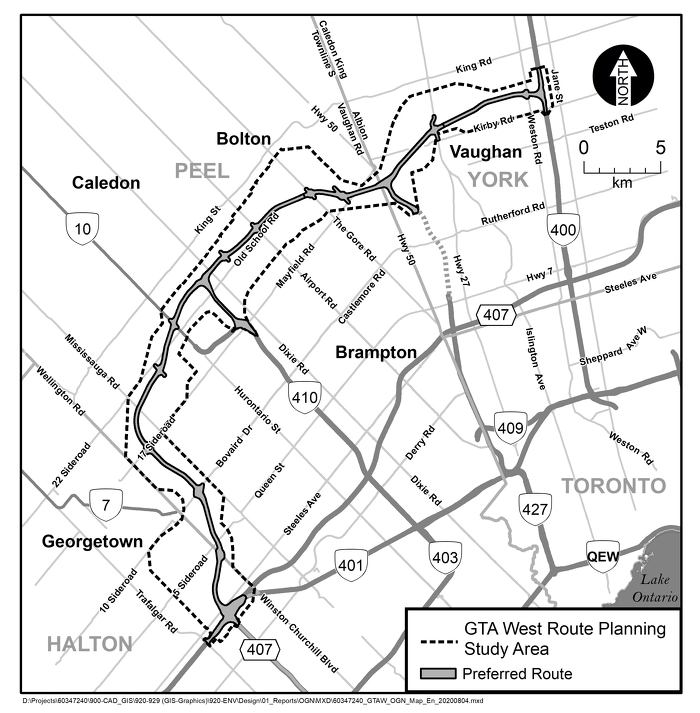
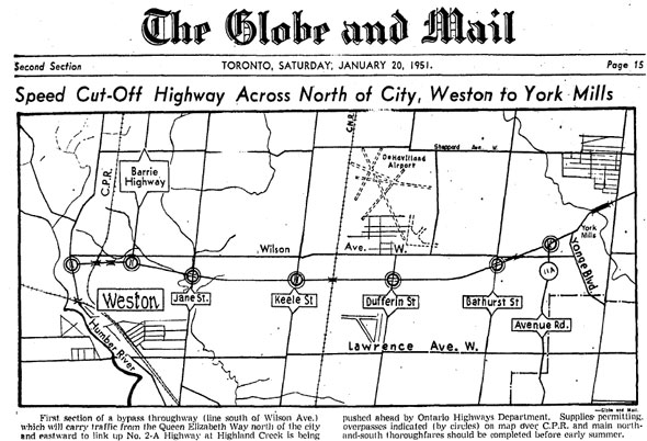
When the Toronto portion of the 401 opened in 1956, then called the “Toronto Bypass” as it was an alternative to Highway 2 which ran through the centre of the city, farmland around here was just beginning to be urbanized. Originally just two lanes in each direction, the 401 passed just south of the Bathurst St. and Wilson Ave. intersection.

The Toronto Archives’ online aerial photograph collection reveals the story of how quickly Toronto expanded. In 1947, Bathurst and Wilson was rural, with just a scattering of residential houses and faint traces in the landscape of the subdivisions that were being prepared, some that would eventually be home to part of Toronto’s Jewish community.

Three years later, as 401 planning was well underway, the area was a patchwork of brand-new housing tracts and streets waiting for houses, some where the 401 would be built just a few years later.

Pull out your phone and type Carhartt St. into a map app. This tiny, dead-end street was once an on- and off-ramp for the eastbound 401, in addition to the on-ramp on Bathurst that still exists today. Highway 401 traffic was funnelled along adjacent Marquette Ave., a residential street.

Similarly, on the north side, wee Brightwood St. was the on- and off-ramp for the westbound 401, funneling people up to Wilson. People actually lived on both 401 approaches, unbelievable today, but it’s telling how tranquil the highway was originally imagined.

However tame it was when first opened, it congested quickly and by 1964 construction was underway for the collector lanes. The aerial photos show wide swaths cleared out, as if a giant eraser was dragged alongside the highway, destroying roads and houses. The ramps at Carhartt were closed on the south side, and a massive off ramp that leads directly to Wilson today was created where Brightwood was, clearing away some houses in the process. Brightwood still exists as a small loop of a street next to the ramp.

Two blocks east of here, Richelieu Rd. is another loop running south of Wilson that was altered by the 401 expansion, and just two houses remain of the original five that were on its east side. All along the 401 sound barrier are streets that were truncated as it expanded.

Again, this is easier to follow with a map app open, but the speed of city growth is apparent in how quickly new houses and streets were completely torn down and removed to make way for the expansion of a highway that now seems as if it’s been there forever. If there is one constant here it’s that the city has always changed, but time has a funny way of covering up the traces of change.

Underneath the highway on Bathurst the “growth rings” of the 401 are visible in the gentle arc of the original central overpass that looks like some of the early overpasses that still exist on rural sections of the 400 series highways. The more angular collector lane overpasses that came later are next to it, heavier on the engineering and less on the architecture.

A westbound on-ramp on the north side of the 401 at Bathurst and Wilson was also removed, and the triangle of leftover land that was created eventually became what is now the Bathurst-Wilson Parkette. In 2016, it got an update with a Mabuhay (Welcome) Garden to recognize the presence of the Filipino community that has made this area home, and includes more seating, a pergola and new landscaping.

A massive mural designed by artist Ian Leventhal was installed on the 401’s retaining wall here in 2005, a project under former mayor David Miller’s “Clean and Beautiful City” program. It has tranquil scenes that, at times, resembles Georges Seurat’s famous 1884 painting of Parisian swimmers, “Bathers at Asnières.”
And today, from Google Maps, at this link.
1638978224933.png
 
Last edited:
View attachment 367835
The awkward thing about limiting this tomfool highway to a 427-400 link as a compromise is that's the part that's the most environmentally damaging. East of 427 the route goes through farm fields, but between 427 and 400 it goes through the greenbelt with all the headwaters and sensitive habitats that involves.

I think the goal of this highway is to facilitate a lot of suburban sprawl, in which case you could skip the link to the 400 and just loop the 410 to the 427 to turn it into a choker around the Brampton blob.


If maybe just a 427 400 highway it could have route changed.

I just think that is the only part of the highway that makes sense from a traffic point of view. Rest serves no real purpose really.
 
Hahaha no, these parties are too busy appealing to the environmentalists to even bother thinking of a new plan. But it's okay, if this project gets canceled, everything those environmentalists claimed the highway would cause to happen, WILL STILL HAPPEN WITHOUT THE HIGHWAY.

THE WHITE BELT WILL STILL BE DEVELOPED

And if you think I'm a doomer, then you're wrong, I'm just looking at reality.
Not sure why "environmentalists" is being used like its a bad word here.
 
Hahaha no, these parties are too busy appealing to the environmentalists to even bother thinking of a new plan. But it's okay, if this project gets canceled, everything those environmentalists claimed the highway would cause to happen, WILL STILL HAPPEN WITHOUT THE HIGHWAY.

THE WHITE BELT WILL STILL BE DEVELOPED

And if you think I'm a doomer, then you're wrong, I'm just looking at reality.

While I certainly oppose that sprawl and hope it does not come to pass; it would still be preferable were it tied to new transit service rather than a new 400-series highway.

But lest you believe all sprawl is immutable; we recently saw lands up near Lake Simcoe downzoned and turned over to the local Conservation Authority for permanent protection after development had been previously approved.

I'm not naive and recognize that won't happen for each remaining acre of the white belt, and probably not 1/2 either, though I find that disappointing just the same.

But the more than can be saved the better.
 

Back
Top