News   Jul 12, 2024
 1.2K     0 
News   Jul 12, 2024
 1K     1 
News   Jul 12, 2024
 373     0 

Miscellany Toronto Photographs: Then and Now

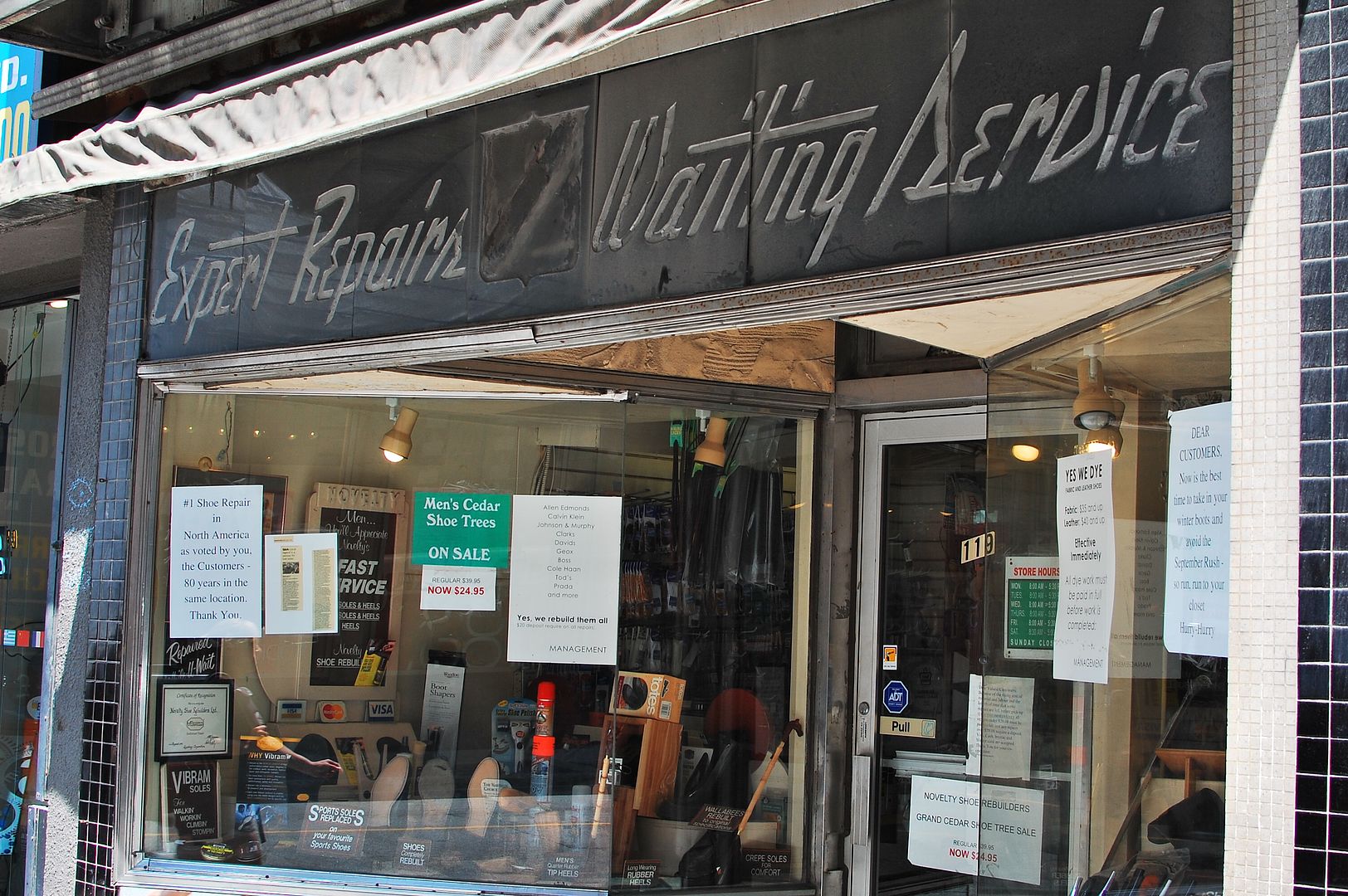
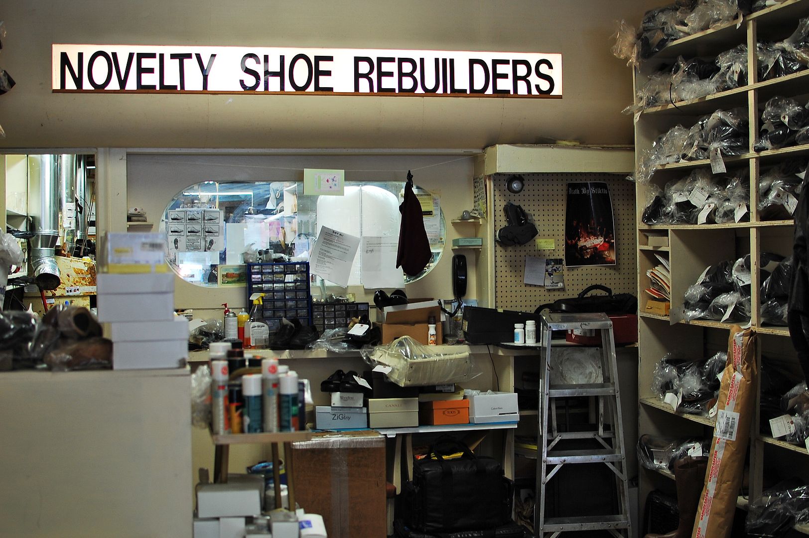
Novelty Shoe Rebuilders has been a fixture on Yonge since 1932. That's 80 years this year. The store has made 'background' appearances in past Then and Nows in this thread.

I have to make at least an annual visit because I am hard on my heels - wearing them down on one side. Years ago, Novelty would do my leather soled shoes - I still have these but I only wear them for special occasions. Nowadays I wear 'Rockports' on a daily basis because of all the walking I do. Novelty does a splendid job on Rockports - or any 'gelled' soled shoes for that matter - a 'Vibram' sole is artfully glued onto the old sole. It looks like it came from the factory that way.

I was in the store recently and took a couple of pictures.

CSC_0062.jpg


CSC_0063.jpg
 
Then and Now for July 23.


Then. Looking WNW along Dundas Square towards Yonge. 1980ish.

690.jpg


Now. May 2012. Hmmm, some 'movie prop cars' in the foreground. Toronto is standing in for New York City (again :)).

691.jpg
 
wanting to post some unique photos taken in late 1969 and mid 1976 of CIBC building

Hey it's the weekend again.

This link is somewhat related to Then and Now. Cindy Sherman is a visual artist and photographer who uses herself as the subject in surreal and fantasy photographic compositions. I say somewhat related because she has been doing this for over thirty years. Be warned, some of her work can be upsetting.

http://www.nytimes.com/slideshow/2012/02/19/arts/design/20120219-SHERMAN.html
Hi: I need to know where and how I can post photos of CIBC taken in late 1969 and 1976 of the building that was built in 1930. I have one photo of the tower building from the TD tower before the CBIC tower was built in between the 2 buildings. thank you. my email address is 'oldiaverlyn@hotmail.com'
 
Last edited:
Thanks r937

Loved your post.

I realize now that I used to walk my dogs up Royal Drive everyday, through Riverdale Park.

Today I passed Broadview/Danforth in a car so I couldn't grab a shot but there's definitely a sign in that heinous new blue-and-white style stating "Royal Drive" where the on-ramp to the DVP is. I am not sure if somebody already confirmed this or not.
 
Hi: I need to know where and how I can post photos of CIBC taken in late 1969 and 1976 of the building that was built in 1930. I have one photo of the tower building from the TD tower before the CBIC tower was built in between the 2 buildings. thank you. my email address is 'oldiaverlyn@hotmail.com'

Hi archoman,

Welcome.

You can host your pictures on a site such as http://photobucket.com/ and upload them here or send them to me as attachments at mustapha.low@hotmail.com and I'll do it for you.
 
Thank you: ok I will scan them tomorrow and attach them in email to you. I have a few rare photos mainly I took back then but the one of the CBIC building (1930) is quite unique looking down look view.
 
Rediscovering Royal Drive

the pictures date back a couple of months, and it took me until today to finish writing it all up

all i wanted was this one shot of the end of winchester street just before the bayview extension --

the-end-of-winchester-street.jpg

Thanks for doing this. I've been curious about Winchester for a while and I admire your determination in following the course of a road that is no longer there!

Regarding your photos from around the Brickworks: the Governors Bridge lookout reminds me that it would be nice if that neighbourhood were connected by a trail to the edge of the quarry, but I don't know how feasible that is.
 
... the Governors Bridge lookout reminds me that it would be nice if that neighbourhood were connected by a trail to the edge of the quarry, but I don't know how feasible that is.
the neighbourhood around governor's road, douglas cres, and nesbitt drive has several paths to the don branch rail line, from which there are a couple of access points to the quarry

i'm not sure if the neighbourhood to the southwest of the bridge (astley ave, standish ave, glen road, etc.) is also called governor's road or is part of summerhill village or north rosedale, but from chorley park there's a path down to the belt line trail which connects to the brick works

granted, these paths i mentioned are not trails per se
 
the neighbourhood around governor's road, douglas cres, and nesbitt drive has several paths to the don branch rail line, from which there are a couple of access points to the quarry
per se

Do you know where the access points are approximately? I know of a path from Bayview, north of Pottery Rd, that crosses the Don Branch, but being able to the rail line from above the quarry is new to me.
 
I'm so fond of the history of Winchester Dr. that I decided to place these two pics together as a Then & Now.
The recent photo is, as we all know, from that wonderful essay by r937 <Rediscovering Royal Drive>.


This was once the Winchester route into the Don Valley.
Winchesteratzoo1907.jpg


Today it disappears abruptly at the Bayview Extension.
WinchesterDr-end-byRudyLimeback.jpg

This photo is described as of the Bayview Extension under construction in 1957, although it looks more like the construction of the DVP to me. Is this the last Winchester St bridge?
s0065_fl0075_id0003.jpg
 
Do you know where the access points are approximately? I know of a path from Bayview, north of Pottery Rd, that crosses the Don Branch, but being able to the rail line from above the quarry is new to me.
the easiest is here -- http://www.flashearth.com/?lat=43.693345&lon=-79.366032&z=18.7&r=0&src=msl

what you're looking for is these two pines --

from-true-davisdon-drive-down-to-the-ravine.jpg


there's another access point across the road (true davidson drive) that actually follows that part of abandoned pottery road, but it's a fair bit steeper

then, of course, there are numerous access points via people's back yards on douglas crescent, but i guess you have to know which ones, and you shouldn't be using those anyway

Wow, that's quite well hidden. Thanks, I had no idea and will definitely check that out. Would you say it was bikeable or is it more of a hiking track?

I once tried to get to the Brickworks from the south end of True Davidson but there really didn't seem to be a way to do it, so this is a big help.

I'm all for public lands being publicly accessible, but I do draw the line at people's backyards.
 
Wow, that's quite well hidden. Thanks, I had no idea and will definitely check that out. Would you say it was bikeable or is it more of a hiking track?
none of the paths to the top of the quarry walls is bikeable

I once tried to get to the Brickworks from the south end of True Davidson but there really didn't seem to be a way to do it, so this is a big help.
there definitely is no access from there, despite what lostrivers says -- i tried it once, got half way down the hill, and had to bail... the only time i've ever bailed on a hill climb/descent (i would rate the difficulty on a scale of 1 to 10 as an 11)... you can see that hillside near the beginning of this short video taken from old pottery road alongside cudmore creek, just before coming out at bayview
 
Last edited:
none of the paths to the top of the quarry walls is bikeable

You just saved me a lot of trouble. I'll have to explore it on foot from the twin pines onward then.

there definitely is no access from there, despite what lostrivers says -- i tried it once, got half way down the hill, and had to bail... the only time i've ever bailed on a hill climb/descent (i would rate the difficulty on a scale of 1 to 10 as an 11)... you can see that hillside near the beginning of this short video taken from old pottery road alongside cudmore creek, just before coming out at bayview

My attempt (by bike) to descend from True Davidson to the Brickworks ended with me just riding down Bayview to the point at the end of your video, then walking it up to the top of the quarry wall.
 

Back
Top