News   Jan 10, 2025
 2.1K     6 
News   Jan 10, 2025
 1.4K     1 
News   Jan 10, 2025
 642     0 

Cycling infrastructure (Separated bike lanes)

No, there is enough space on the existing roadway, for a 3 metre road lane in each direction, 0.5 metre buffer(protection in buffer), and 1.5 metre bike lane.

At 9.9M curb to curb, that's a squeeze: (but give or take 0.1M, do-able)
1606938265851.png
 
No, there is enough space on the existing roadway, for a 3 metre road lane in each direction, 0.5 metre buffer(protection in buffer), and 1.5 metre bike lane.

Lots of room on those medians but I take it that people would be up in arms about cutting down those trees
 
Of the streets where I drive often, Sheppard and Leslie are also in poor shape and need improvements. The city plans to resurface Leslie in the next four-five years. Who/how/where could we pressure to get cycling and pedestrian protection when Leslie is rebuilt? Same question for Sheppard, but because it's further down the line—how do we force the city to put Sheppard on the to do list?
 
The City is applying for Covid Resilience funds from the Federal Gov't as outlined in this report to the Dec 10th Executive Ctte.

The funds include two segments relevant to cycling infrastructure; as noted in 2 partial cross-posts to the Vision Zero and Ravine Strategy threads.

Report here:


Details (as such), in this attachment: https://www.toronto.ca/legdocs/mmis/2020/ex/bgrd/backgroundfile-159137.pdf

Relevant Transportation Projects section:

1607009526521.png


Also a Parks/Ravines section which impacts cyclists as well:

1607009574847.png
 
Not Toronto; but nearby and notable.

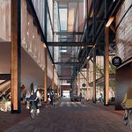
Kitchener has approved a new 10km cycle grid for its downtown, including new trails and 2.8km of separated bike lanes.

 
Not Toronto; but nearby and notable.

Kitchener has approved a new 10km cycle grid for its downtown, including new trails and 2.8km of separated bike lanes.

This is looking pretty good! Some good quality curb separated lanes.
Some more info https://www.engagewr.ca/downtown-cycling-grid
Map (from link above):
1608239388410.png

Renderings taken from link above:
Water St.
1608239464370.png

Joseph St
1608239528081.png

Duke St W
1608239690443.png

Duke St E
1608239618827.png

Cedar St
1608239734673.png

Margaret Ave MUT:
1608239913821.png
 

Attachments

  • 1608239465685.png
    1608239465685.png
    791.1 KB · Views: 217
  • 1608239530206.png
    1608239530206.png
    1.2 MB · Views: 214
Transform Yonge (the downtown North York stretch, including separated bike lanes) just passed Council, 18-5!!!!

:D

The vote, for the record: (courtesy @matt Elliott's twitter)
View attachment 289538

Ford, Holyday, and Minnan-Wong voted NO! No surprise there. Have to watch Pasternak and Thompson.
 
KW has done a lot of great work over recent years on bike infrastructure from where they were 10 years ago. We can only hope they start to figure out protected intersections. It might be that a smaller city needs to implement them before it can penetrate the GTA.
They also have a lot of painted, unprotected bike lanes on high speed suburban arterials. Good in theory but in practice not a nice environment to bike. Hopefully that's changing.
 

Back
Top