News   Jun 28, 2024
 2.2K     2 
News   Jun 28, 2024
 1.4K     1 
News   Jun 28, 2024
 570     1 

Transit Fantasy Maps

Some suggestions for the map:

- Viva orange could use the new routing (via the busway with stops at Dufferin/Finch, and Murray Ross Pky).

- The legend should say Bus Rapid transit and Streetcar Rapid Transit (or something along those lines), since the 509 and 510 aren't BRT.

- Some commuter rail lines run at off peak times.

Other than that (and the interchange problem), it's a great map. Nice work.
 
While lurking around the internet, I found this alternate, more readable map of the NYC Subway. by KICK design
3_brooklyn_comparison.jpg

http://www.kickmap.com/index.php
The site says you can download it from the APP store, but does anyone know if its avaliable in a scalable format such as pdf anywhere on the internets? The only PDF that I did find was just an image, barely readable.
 
Does anyone wanna say headache?

Great map. Kudos on successfully integrating all the major systems. It's great to see the big picture.

Unfortunately, there is an error. Richmond Hill Centre connects with Langstaff GO, not Richmond Hill GO.

Richmond Hill GO is two concessions further north, roughly at the same level as Maple GO.
 
Last edited:
Great map. Kudos on successfully integrating all the major systems. It's great to see the big picture.

Unfortunately, there is an error. Richmond Hill Centre connects with Langstaff GO, not Richmond Hill GO.

Richmond Hill GO is two concessions further north, roughly at the same level as Maple GO.

BAH. Stupid GO. I'll fix it when I get a chance and repost.
 
While lurking around the internet, I found this alternate, more readable map of the NYC Subway. by KICK design
3_brooklyn_comparison.jpg

http://www.kickmap.com/index.php
The site says you can download it from the APP store, but does anyone know if its avaliable in a scalable format such as pdf anywhere on the internets? The only PDF that I did find was just an image, barely readable.

The MTA's map is not pixelated like that. They only added the pixelation to make the comparison more favourable. Personally I like the MTA's maps.

The Kick map is pretty bad. Background is no longer neutral colour. It is too detailed and colourful and so the subway lines don't stand out anymore. Completely getting rid of the geographic scale was probably also pointless.
 
While geographically accurate maps are absolutely essential for surface routes, for the sake of making connections between lines more visible, I think the Kick map does its job well. Also, by phisically separating the different branches of each line, and by placing the train number/letter on the actual stop, it makes reading which connections can be made more apparent.

If i were to make this map, I would probably further mute the background colours of the neighborhoods or turn them monochrome beige. However, having the white outline of each subway line and by giving each train its own line, I don't see the different coloured background as much of a detractor from overall readability, but that could just be me.
 
Here's a retouching of the fantasy map that I posted in the other thread with name-tags for all of the stations. Feel free to give constructive feedback.

WithStationNameplates.jpg


Discussing the lines in further detail:
DRL-
  • begins at Commerce/Matheson, terminal of the impending Mississauga Bus Rapid Transit Transitway;
  • veers northwest into Terminal 1, opposite to the people-mover tram station;
  • runs east along Dixon Road serving high-density employment areas;
  • runs through the hydro corridor lands adjacent the 401;
  • runs east for 6 kilometres above-grade in the Richview Corridor with a breif underground section between Mulham and Scarlett Rd;
  • at Mount Dennis Stn trasnfers onto the Jane-Eglinton-Don Mills Line and Guelph GO Line are possible;
  • runs 5 kms southeast to Bloor-Lansdowne via the Silverthorn, Junction high-density residential-commercial neighbourhoods;
  • runs 4 kms southeast via Dufferin/College/Spadina/Front to Union Station passing through several high-density residential-commercial neighbourhoods;
  • runs 4 kns northeast via Esplanade/Parliament/Gerrard/Pape to Danforth-Pape passing through several high-density residential-commercial neighbourhoods;
  • runs 5 kms northeast to Ontario Science Centre via the Pape Village, Thorncliffe Park high-density residential-commercial neighbourhoods;
  • runs east for 6 kilometres above-grade to Ionview Station;
  • runs underground for remaining 6 kilometres from Ionview to Kingston Road terminus;
  • at Midland Stn transfers onto the Bloor-Danforth subway and Uxbridge GO are possible;
  • at Brimley Stn trasnfer onto the Bloor-Danforth subway is possible;
  • at Bellamy Stn transfer onto the Lakeshore REX line is possible;
  • ends at Kingston Rd/Scarboro Golf Club, terminal of a potential joint Toronto-Durham Kingston/Pickering-Ajax Bus Rapid Transit Transitway.

Jane-Eglinton-Don Mills ICTS
  • begins at Steeles West Stn on the Yonge-University-Spadina Line;
  • stop at the Rexall Centre prior to Jane ROW;
  • runs 10kms south along Jane-Weston Road through mixed at-grade (Murray Ross Pkwy to Falstaff), above-grade (Falstaff to Weston-Galt Sub) and below-grade (Weston-Galt to Mt Dennis) right-of-way;
  • runs 1km elevated parallel to Eglinton Ave from Weston-Galt to Bicknell St;
  • runs underground for 11 kilometres underneah Eglinton Avenue from Bicknell, west of Keele, to halfway in-between Brentcliffe and Leslie St;
  • runs elevated southeast to OSC for 1 kilometre;
  • faces north-south at OSC Station. Transfer onto the DRL possible at this station stop.
  • runs north above-grade parallel to Don Mills Road for 6 kms til just south of Sheppard Avenue;
  • dips underground and runs 300 metres east to the renamed Fairview Subway Station;
  • runs north of the subway adjacent to the 404 in a mixed at- , above- , below-grade ROW to the Steeles East interchange stop @Shops on Steeles and 404 Shopping Centre;
  • at Seneca College Station customers may transfer onto the FHC busway line(s) or the 39 Finch East bus.

Sheppard Line enhancements

Westwards/Southwards
  • To improve the functionality of this service, existing stations are lengthened to house 6-car trainsets;
  • line extended 500m west to Senlac Station to better cater to western NYCC residents and businessowners, and to shorten the bus commute for 84 Sheppard West passengers seeking to get onto the subway;
  • Sheppard line routed down Easton/Gwendolen in a deep stacked single bore such as to minimize adverse affect upon local community;
  • line surfaces in routes on the outskirts of Gwendolen Pk in a southeasterly direction above-grade over the Don Valley and the 401;
  • line dips underground west of William Carson Cres/Yonge St, south of the 401;
  • new side-tunnel offshoot inbound and outbound tracks installed north of York Mills Stn;
  • new signaling measures ensure that trains can safety enter and exit the main trunk of the Yonge subway corridor at optimal speeds/headways.

Eastwards
  • 7 kilometre extension from Fair to Glen Watford Station passing through several high-density residential-commercial-employment centres en route;
  • 1 kilometre long below-grade section between Glen Watford and the 401/Brimley via Sonmore/Marilake in a deep stacked tunnel;
  • subway parallels the east side of Brimley until Borough Dr;
  • dips underground to terminate at Scarborough City Centre (NOTE: Some trains during peak hours will go beyond this point to serve and Bloor-Danforth subway line and vice versa).

Bloor Danforth
  • Westwards 3 kilometres to Sherway Gardens;
  • Eastwards 6 kilometres to Scarbrough City Centre (some trips go to Union Stn via Sheppard Subway).

Yonge North ICTS
  • underground from Finch to York Sub;
  • at Glen Cameron Station, connections to on-street Yonge @Clark and buses;
  • at-grade within York sub til east of Bayview;
  • mixed at- and above-grade operation in Bala from Thornhill Square Station to 16th Avenue;
  • at Richmond Hill Centre transit hub transfer onto 407 BRT Transitway, Richmond Hill GO, VIVA Purple, Yonge Local BRT;
  • underground station at Hillcrest Mall;
  • road-median, some grade-separated ROW operations with signal priority from Hillcrest to 19th/Gamble.


Toronto/416 Busways

  • 403-Finch Hydro Corridor BRT
  • Finch/F.H.C. Local BRT
  • Finch East-SCC Express BRT
  • Finch East-Sheppard East BRT
  • 401-Keele BRT
  • Lawrence East BRT via 401/DVP
  • Victoria Park-O'Connor BRT
  • Southern Toronto BRT
  • Kingston Rd Local BRT
  • Kingston Rd Express BRT

And believe or not, there's one more level of detail to my plan which I have yet to share with the forum. Stay tuned! :)
 
The core network should be lines that are straight as possible. Get people close to their destination faster and build cheaper, then transfer to local service. The Places To Grow centres should be the target destinations for routes and in between the routes should follow a near straight line which would provide locations for eventual or existing development nodes 1km apart. There is little point in eliminating a transfer going to the airport from downtown because if fast service is a must there is AirRail. It is much better to have an Eglinton line which crosses all north-south lines and bus routes for connectivity than a route which is east-west part of the time and north-south part of the time. There is little value in two main routes which are never that far apart from each other to begin with to converge at Steeles and Finch, a waste of money to divert west to Don Mills and Steeles when the Places To Grow north of Steeles is Markham Centre, goofy to go to Senlac on the way to downtown to avoid a transfer that would often take as long, expensive to wind routes all over downtown to avoid people having to walk a couple of blocks to brand name areas like "Chinatown", "Cabbagetown", "Kensington Market", etc.

Make routes go straight! Straight lines cross all other non parallel lines providing better transfers. Straight lines cost less. Straight lines get you places faster.

I can see the thought process of the map and it simply doesn't make sense. The premise of the map is make the Sheppard subway valuable, make my hydro corridor BRT running only a major city block north of Sheppard look like it fits into the network, hit all brand name city districts with a single line, and for the love of god don't allow another city line cross the oh-so-important 416/905 border. These are not the ways a transit network should be designed. The core network should be straight lines which intersect other straight lines and it is the non-core network that should take people to every nook and cranny of the city.

These are schematics of the Places to Grow points and the coloured lines represent the routes which are or could meet the needs of that network. The lines are not where the actual route would go but the actual route should try to accomplish the goal of that network segment as directly as possible.
 

Attachments

  • GTAGrid.jpg
    GTAGrid.jpg
    60.7 KB · Views: 225
  • GTANetwork.jpg
    GTANetwork.jpg
    59.2 KB · Views: 290
I think the DRL should serve Jane and Don Mills, and the crosstown be entirely the Eglinton line.

Sorry it's taken so long to get back to y'all's replies.

Ideally yes, the DRL could continue up Don Mills Road past Fairview to perhaps terminate at Seneca College. But from a costing standpoint it is better to expand northwards as LRT in its own ROW. Don Mills/Eglinton is a natural end-point, with the convergence of several major transportation corridors within proximity (Hwy 404/DVP, GO Peterborough, GO Richmond Hill, Eglinton-Crosstown and Don Mills northwards) and on-site trip generation (OSC, Celestica, nearby high-rise apartment and office buildings, FP Shopping Ctr).

The biggest criticism and perhaps biggest misunderstanding the forum appears to be having in regards to my fantasy map proposal, is concerning the splitting of Eglinton by two major underground/elevated metro lines instead of just having one line straight across. It's ironic that most feel this way because my plan is perhaps the surest way to guarantee a subway right across the Eglinton corridor. Think about it:

  • The DRL cannot be built as anything other than as a metro subway (forecasted to exceed > 10,000 pphpd).
  • Central Eglinton rapid mass transit of any shape or form cannot be built as anything other than within an underground ROW.
  • Right here in Canada, the City of Montreal has had the intellect and capability to create subway interchanges like Lionel-Groulx whereby the outbound tracks of two different subway lines meet at the same platform area across from each other, and the inbound tracks of both subway lines have the same configuration.
  • The percentage of travelers going all the way across from eastern Scarborough to Mississauga is relatively small, so small in fact the TTC doesn't even think it warrants a one-seat ride all across Eglinton by enforcing a split at Kennedy.
  • The trip-orientation and travel-flow based on today's standards is a suburbs to core routing, not suburb to suburb.
  • Most international cities of Toronto's size, density and population have a metro subway route either directly into or run within a few kilometres of its international airport. PIA constantly ranks within the world's 30 busiest, meaning over 100 smaller cities worldwide have better rapid transit accessibility to their international airports. DISGRACEFUL!

It is for all these reasons that I thought,
  • Pearson needs a subway
  • DRL will stretch as close as Mount Dennis and OSC, if they're smart
  • Kennedy Stn needs alleviation
  • At 9400pphpd or greater by 2021 Eglinton will soon need a crosstown subway
  • Perhaps we can trick the TTC/Metrolinx into building an Eglinton subway via supporting some of Transit City (Jane and Don Mills) and in the process also get the DRL built that would help out so many more commuters.

I'm surprised that no one as yet has recognized the beauty of such planning. The light-rail supporters are appeased, as are the Eglinton subway sect, as are the DRL lobbyists... win, WIN, WIN!

In other words, if my journey started at Markham/Eglinton and I was going to Martin Grove/Eglinton, I would have to transfer twice to make it all the way across. But even doing so my journey would still take only 45 minutes compared to 80+ minutes today. The key is not how the lines are built, it is in how they'll be operated. Getting off the DRL at OSC Stn during peak hours, I may see an LRT trainset show up every 90 seconds or better. Under such circumstances my "transfer city" is in no way as extremist as the TTC's because my "ICTS" line incorporates grade-separation and ROW exclusivity as much as possible to avoid on-going delays at intersections. Directly serving key nodes such as Seneca College, whereas DMLRT bypasses it, is also a plus (so is utilizing highway endowment lands as much as possible vs. on-street ROW construction around the Peanut where ridership levels is low enough to be left up to buses).
 
The core network should be lines that are straight as possible. Get people close to their destination faster and build cheaper, then transfer to local service. The Places To Grow centres should be the target destinations for routes and in between the routes should follow a near straight line which would provide locations for eventual or existing development nodes 1km apart. There is little point in eliminating a transfer going to the airport from downtown because if fast service is a must there is AirRail.

The metro line (DRL) that I've prescribed has in entirety wider turning radii than several spots within the existing TTC subway system. Note the narrowest curve on the TTC is 116m; mine where the DRL swings north up Parliament St is 220m. Deep-channel subways through the central core of the downtown involve minimalist expropriation nor disruption to the surface life above it and if built in one shot can be substantially cheaper to build than the TTC's existing TBM/Cut-n-cover method.

It is much better to have an Eglinton line which crosses all north-south lines and bus routes for connectivity than a route which is east-west part of the time and north-south part of the time.

Except that the TTC refuses to build an Eglinton subway that goes right across east-west all of the time. They want underground LRT through the median and the city cannot afford a subway right across nor is it politically feasible to invest so much money if we even had it on one single corridor. Tricking the status quo into extending the DRL east-west along Eglinton but at the same time appeasing their LRT plans however just might be achievable.

There is little value in two main routes which are never that far apart from each other to begin with to converge at Steeles and Finch,

Steeles and Finch converge?

If you meant Jane routing into Steeles West, my end-goal is to extend that line up to Vaughan Mills and Paramount Canada's Wonderland.

a waste of money to divert west to Don Mills and Steeles when the Places To Grow north of Steeles is Markham Centre

Why must you assume that's where I envisioned the line to end? It's a Toronto-centric map. I wanted to showcase my plans for Toronto first before I expanded to the region. I have the maps up already for it, but I want the forum to digest the first image first. Also if I'm following the path of the 404 heading northwards, then my line is precisely where it should be for further expansion.

, goofy to go to Senlac on the way to downtown to avoid a transfer that would often take as long,

Wasn't it you who said that the lines must be as straight as possible? In order to make the curve back into Yonge fast and screech-free, you must extend to at least past Senlac. If I did not include the stop en route though then I would have been accused of not caring about Sheppard West. See, I cannot win.

expensive to wind routes all over downtown to avoid people having to walk a couple of blocks to brand name areas like "Chinatown", "Cabbagetown", "Kensington Market", etc.

Okay, this one is just absurd. Since when is Chinatown walking distance of Bloor or Spadina/Front (Spadina/Wellington) where the studied DRL is most likely to go? Or Cabbagetown in relation to Castle Frank or Parliament/Esplanade? Or Bathurst/Dundas in relation to Bloor/Bathrust or Fort York? It is the TTC that wants to create redundant transfer points in order for a bulk of travellers to access major destinations. Cityplace is only relevant for the 9 to 5 crowd whom have a preexisting rail corridor at their disposal upon which DMU local transit can be operated if warranted. All-day demand preexists for the areas outlined in my map.

Make routes go straight! Straight lines cross all other non parallel lines providing better transfers. Straight lines cost less. Straight lines get you places faster.

Why if I'm going to Dundas/Beverley of what good to me is a DRL if I still have to transfer twice after I'm done riding it (YUS + 505 or 510 + 505)? Also note the perils of surface transit when doing such backtracking with locally spaced stops and many signalized intersections in contrast to a traffic-free underground commute wherein adjacent buildings can be connected to a subway station.

I don't know whether you use the Downtown streetcar system that often, but for me it is obvious where the major transitional points are along the line, where most people get off and a different set of passengers start to board. I tried my best to locate stations where these congestion points exist in the street-grid and transit network.

I can see the thought process of the map and it simply doesn't make sense. make my hydro corridor BRT running only a major city block north of Sheppard look like it fits into the network, hit all brand name city districts with a single line, These are not the ways a transit network should be designed. The core network should be straight lines which intersect other straight lines and it is the non-core network that should take people to every nook and cranny of the city.

When the TTC can operate the surface network remotely as good as it can subways then I will agree with you. Til then, assuming the DRL is the last major subway line that'll be built in Toronto, why build it in a preexisitng transit corridor, even if saving money is the goal of that? Add GO stations to Liberty Village, Parkdale, Brockton, West Don Lands and Riverdale if you want to; but don't continue to shortchange Downtown residents whom have patiently awaited a new subway line their whole lives only to find out what's going to be built will have absolutely no meaning to them.

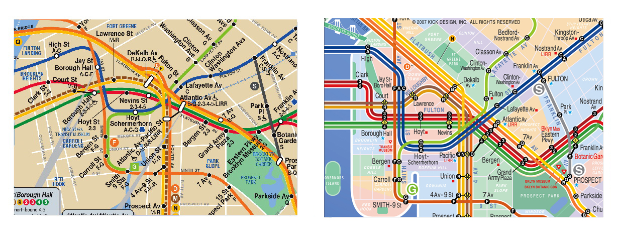
Every nook and cranny? Have you ever been to NYC or even took a gander at the map of the MTA above? Lol! Even after my version of the DRL, there'd still be wide enough a gap for a Queen Street subway.

The premise of the map is make the Sheppard subway valuable,

+1

I'll discuss BRT later, but I'm curious about what you'd have them do to the Sheppard Line. Does a daunting $500 million bridge across the West Don River alone not suddenly make the cries for a Sheppard West extension to Downsview seem completely unreasonable? But the tail-tracks presently peter out just east of Senlac where will be engulfed by NYCC's westward expansion. Saving customers the transfer will increase the number of people that use Sheppard subway everyday, bolstering the case to expand it eastwards. And guess what if warranted, any expansion out to Senlac could be done as such to eventually extend westwards. So my planning isn't as obtuse as many here would like to believe. I thought of everything.

and for the love of god don't allow another city line cross the oh-so-important 416/905 border.

I've planned subway-standard mass transit for both Mississauga and Thornhill/Richmond Hill. That it's not an Orion T1 pulling up at the stations is a pissing contest best to be left up to the thinking process of the ignorant and misinformed.

These are schematics of the Places to Grow points and the coloured lines represent the routes which are or could meet the needs of that network. The lines are not where the actual route would go but the actual route should try to accomplish the goal of that network segment as directly as possible.

Enviro, believe you me, you have no idea just how much I've combed over studies such as Places to Grow in the past several months and have come up with an integrated rapid transit network concept that will bring everyone from Oakville to Brampton to King City to Box Grove to Oshawa within an hour of Toronto regardless of where they live.
 
I'm surprised that no one as yet has recognized the beauty of such planning. The light-rail supporters are appeased, as are the Eglinton subway sect, as are the DRL lobbyists... win, WIN, WIN!

Obviously they haven't recognized the beauty of such planning because they aren't as smart as you. Wow. You're brilliant.

The metro line (DRL) that I've prescribed has in entirety wider turning radii ....

Turning radii has nothing to do with going straight.

Except that the TTC refuses to build an Eglinton subway that goes right across east-west all of the time.

If map is about what the TTC is actually planning to build... I think your map is off. If what the TTC refuses to build is guiding your plan then your map should really match the Metrolinx and Transit City plan.

Steeles and Finch converge?

If you meant Jane routing into Steeles West, my end-goal is to extend that line up to Vaughan Mills and Paramount Canada's Wonderland.

Yes, I meant Jane and Steeles. With the whole perimeter of the city to serve it doesn't make sense to send two lines that roughly parallel to each other to the same point... especially a place so un-important.

Why must you assume that's where I envisioned the line to end? It's a Toronto-centric map. I wanted to showcase my plans for Toronto first before I expanded to the region. I have the maps up already for it, but I want the forum to digest the first image first. Also if I'm following the path of the 404 heading northwards, then my line is precisely where it should be for further expansion.

You divert the subway east from Don Mills to 404 at the hydro corridor, and west back to Don Mills at Steeles. That is a waste of money. How is it the perfect spot for future expansion? There is already a north-south line on Yonge and no lines east of there... why would this line ever need to head west? The closest unserved Place to Grow is east of there.

Wasn't it you who said that the lines must be as straight as possible? In order to make the curve back into Yonge fast and screech-free, you must extend to at least past Senlac. If I did not include the stop en route though then I would have been accused of not caring about Sheppard West. See, I cannot win.

To keep a straight line you turn south at Senlac. I didn't know that.

Okay, this one is just absurd. Since when is Chinatown walking distance of Bloor or Spadina/Front (Spadina/Wellington) where the studied DRL is most likely to go? Or Cabbagetown in relation to Castle Frank or Parliament/Esplanade? Or Bathurst/Dundas in relation to Bloor/Bathrust or Fort York? It is the TTC that wants to create redundant transfer points in order for a bulk of travellers to access major destinations. Cityplace is only relevant for the 9 to 5 crowd whom have a preexisting rail corridor at their disposal upon which DMU local transit can be operated if warranted. All-day demand preexists for the areas outlined in my map.

You designed the map, not me. You are defending your design based on a fictitious DRL on Front which isn't even on your map? Chinatown is walkable from Queen. Much of your DRL routing is following the Dundas Streetcar route which isn't one of the most overloaded routes. The downtown busway plan which curves all over the place. What a mess.

Why if I'm going to Dundas/Beverley of what good to me is a DRL if I still have to transfer twice after I'm done riding it (YUS + 505 or 510 + 505)?

Why not get off at Queen and John and walk. Why would taking YUS be considered a transfer... it is a subway. Not all trips downtown need to take the DRL. It is a relief line, not a replacement line.

I don't know whether you use the Downtown streetcar system that often, but for me it is obvious where the major transitional points are along the line, where most people get off and a different set of passengers start to board. I tried my best to locate stations where these congestion points exist in the street-grid and transit network.

I live downtown. The College streetcar doesn't need its route largely duplicated by a subway. The busiest corridor downtown is around King and Queen where you are planning a busway?

When the TTC can operate the surface network remotely as good as it can subways then I will agree with you. Til then, assuming the DRL is the last major subway line that'll be built in Toronto, why build it in a preexisitng transit corridor, even if saving money is the goal of that?

Once again you are arguing your plan based on what the TTC does. There is no point in your map if everything is based on the TTC's plan. None of the TTC's plans or Metrolinx plans have ever shown anything as far fetched as a DRL curving all over downtown. I have only seen DRL plans on Queen or close to the rail corridor.

Enviro, believe you me, you have no idea just how much I've combed over studies such as Places to Grow in the past several months and have come up with an integrated rapid transit network concept that will bring everyone from Oakville to Brampton to King City to Box Grove to Oshawa within an hour of Toronto regardless of where they live.

You could have fooled me. A Bloor line which ends in a southerly orientation, a Don Mills line which ends heading west, routes converging at Jane and Steeles or Sherway. Where do you think the places to grow are?
 
Sheppard
It would make more sense to extend the line west to Downsview than to build some crazy track that funnels people in to the Yonge line. The Yonge line, being under the major street of our city, will always be the busiest line, so we should provide people with alternatives by extending the Sheppard line to the Spadina line, not forcing everybody onto Yonge. Not everyone wants to go downtown. After all, the original purpose of the Sheppard line was to allow easy inter-suburb travel, not to funnel people onto Yonge.

DRL
There are so many things wrong with this line, but EnviroTO has already mentioned most of them.
I don't think that your DRL fulfills the basic requirements of a DRL: relieving the Yonge line and the Bloor-Yonge interchange
If extended from Don Mills/Eglinton, it would make more sense to extend north up Don Mills than East along Eglinton. As it stands currently, everyone along Don Mills would take the Yonge line downtown. As well, there would be relatively little demand to go downtown along the eastern segment of Eglinton. Anyone coming from north or east of Kennedy station would take the Bloor line since it offers would offer a much more direct route. However, a line along Don Mills would likely have lots of transfer demand, since all the buses east of Bayview would funnel into it rather than the Yonge line.
You say that your plan works because you "guarantee a subway right across the Eglinton corridor", but personally, i'd rather take the Transit City LRT.
 
I wasn't exactly sure where to post this question but I figure here is as good of a place as any. Does anyone know the following 2 things? I'm just doing some work on some detailed drawings of downtown, and I need to know these to determine future stop spacing.

1) How long the standard TTC subway platform length is?
2) What is the average distance from platform end to platform beginning in the downtown portions of the line?

Much appreciated :)
 

Back
Top