News   Jul 15, 2024
 450     3 
News   Jul 15, 2024
 595     0 
News   Jul 15, 2024
 572     0 

Transit Fantasy Maps

Updated to include the GO REX system, which includes a version of the ARL. I include that as part of the GO REX system, because I think that the ARL concept is doomed to fail, and will eventually be absorbed into the GO REX system.

I also didn't include any LRT or BRT lines because I wanted to keep it as a grade-separated system map. Of course the eastern portion of Eglinton probably won't be grade-separated (unfortunately), but it's close enough to be counted as "grade-separated" on the map.

Interlining Scenario.jpg
 

Attachments

  • Interlining Scenario.jpg
    Interlining Scenario.jpg
    96.8 KB · Views: 663
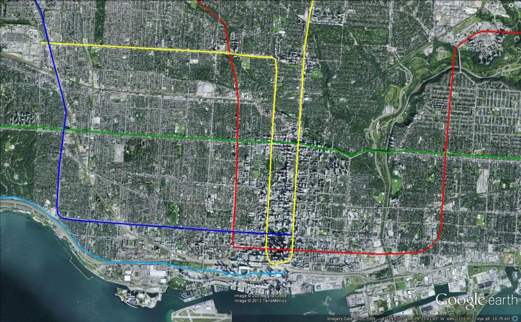
downtown specific:


subway1_zps4560ef43.jpg

I like the idea of the dark blue line, but I'm not sure I'm sold on the St. Clair West line. If you're going to push it straight up Avenue, might as well loop it back to Yonge, so that Yonge from Eglinton to Finch can function as a quasi-express line.
 
There's a subway line less than 400m away. Install signal priority on Spadina, scrap some of the stops and call it a day. We'll now have rapid transit on Spadina for not even a few million dollars.

If you're concerned about the "Champs-Elysee-style boulevard", tear down the Gardiner and replace it with that. It's a far better location as well and is actually realistic from an urban planning point of view.
Are you kidding? Spadina is ideal as a Champs-Elysee-style boulevard. It has the width, it has the established mix of uses, it has mundane buildings to tear down and replace with exceptional buildings and it has the grand terminating vista of Old Knox College. With a midrise scale to the built form it could be spectacular. The University subway is 850 m away, and the ridership on a Champs-Elysee style boulevard could be substantial. Maybe it could be built as a smaller, single-tunnel subway line like the Paris Metro to be cheaper. Your alternative to use Lake Shore is unimaginable. You'd have to demolish a lot of the high-rise condos that turn their backs to the Gardiner presently, which have no retail along Lake Shore and where there's no established retail area. There's no way you could achieve anything remotely similar there. And besides, Queens Quay ought to be more prominent than Lake Shore, anyway.
 
There has been a lot of talk on various threads about how the Union-Pearson air-rail link project might have been more effective as a local rapid transit line rather than a premium express train.

Here is an idea for how the ARL and GTS upgrades could be used to provide rapid transit service along the Weston (Kitchener/Georgetown) corridor.

Rapid Transit is provided as a DRL extension from Dundas West up to the airport, using two tracks of the (under construction) 4-track GO Weston Subdivision, as well as the new airport spur, which will apparently be double-tracked. It would terminate at the elevated U-P Express Station next to the Terminal 1 Link station.

A new mainline rail tunnel to (and importantly through) Pearson Terminal 1 would replace the spur for express service to downtown Toronto, while making rail a very competitive option to air travellers coming from Southwestern Ontario cities such as Windsor, London, Kitchener and Guelph. I suspect that even the slowest services would be faster than the 25min U-P express, since the new rail line would be faster and more direct than the UPE's airport spur.

Mainline service is provided at 3 levels:
- Express: Similar in concept to existing GO service. Would operate at minimal levels off-peak (1-2tph), but would accommodate most of the commuter demand during peak hours (4-5tph).
- Regional: GO line connecting the urban centres along the London-Kitchener-Toronto corridor. Would operate at reasonable frequencies all day (2-4tph).
- Intercity: VIA Corridor service to Windsor, to be gradually upgraded to High Speed Rail, operating at 1-2 tph all day. Service along the London-Burlington-Toronto corridor would be provided by trains from Sarnia instead.

Route Map: Airport Station is actually two separate stations at T1, one on the upper level (next to the Link) and one in the basement, hence the indirect transfer icon.
drlwestroutemaphalf.jpg


Service Map (ignore Sarnia, it wouldn't work due to required electrification):
drlwestserviceshalf.jpg


Track Map:
drlwesttrackmap.jpg


FAQ:

Why is local rapid transit provided by a subway instead of frequent-stop regional rail?


Having the line as an extension of the new downtown subway line would allow for a direct transfer to the Bloor Subway at Dundas West Station. It would also reduce the strain on Union Station by diverting some demand into a new tunnel through downtown. A regional rail line, on the other hand, would likely push Union Station over capacity.

Why have you eliminated Bloor GO Station?

I think that the benefit provided by Bloor Station is exceeded by the benefit of a faster trip for travellers travelling from cities such as Kitchener or Guelph. Travellers on mainline trains can easily access the Bloor Subway by transferring cross-platform to the subway at Mount Dennis Station (where they could alternatively take the Eglinton LRT) and riding it to Dundas West Station. I suspect that transferring to the subway for two stops wouldn't be much slower for them than a stop at Bloor, due to the inconvenient transfer between Bloor GO and Dundas West TTC stations.

Is two tracks enough for all the mainline services in the Weston corridor?

With modern signaling, mainline rail corridors can operate at a minimum separation of 3 minutes, which would result in 20 trains per hour if there were only one service type. Because the different services have similar trip times along the two-track section from Pearson to Bloor, it should be possible to operate trains relatively close to this theoretical maximum.

Isn't it a waste to go back and undo all the ARL and GTS work by building a subway?

Most of the work done as a part of the Air Rail Link and Georgetown South Projects would still need to be done if the line were designed with a subway from the start. The major costs of the projects were to purchase and completely grade separate the GO (formerly CN) Weston Subdivision, to widen the corridor to a minimum of 4 passenger rail tracks at all points, and to build an elevated rail line to the airport.

Why didn't we just do this in the first place?

This proposal is based on the rapid transit component being an extension of a new downtown subway line. Such a line will not open anytime soon, whereas the Union-Pearson Express needed to be operational by 2015 for the Pan-Am Games.
 
Last edited:
It's nice, but you will need more than 2 tracks for GO. CN needs 1 track, with go needing 8 at union, and dropping 2 at each point the line spurs off. (Barrie, Milton, etc)
 
It's nice, but you will need more than 2 tracks for GO. CN needs 1 track, with go needing 8 at union, and dropping 2 at each point the line spurs off. (Barrie, Milton, etc)

You'll notice on the track diagram that I have not changed anything south of Bloor. There are still a total of 8 tracks, with Milton and Barrie each having their own pair. The only change is the part where the subway takes away two tracks (one in each direction).

CN does not need its own tracks, since the amount of freight service south of the Weston Station is small enough that it can be simply accommodated off-peak. Note that most of the freight trains running along the Kitchener line exit onto the York Sub east of Bramalea. In my proposal, CN would have its own tracks from where the passenger trains would dip into the tunnel to the airport, in order to serve the sidings in that segment.

The reason we needed 4 tracks for the Kitchener Line was not for sheer capacity, but rather to in order to maintain capacity despite differing service patterns. Having services with different average speeds causes a severe hit to line capacity.

For example, take a segment of single track (one direction) with two services, one of which takes 15 min longer to traverse the segment of track. Assuming a minimum separation of 3 minutes and alternating services, the fast service needs to enter the segment 3 minutes ahead of a slow service, and a slow service needs to enter the segment 18min ahead of a fast service.

The capacity would be roughly 5.7 trains per hour per direction (6 trains every 63 minutes).

If, on the other hand, all the services had the same average speed, the capacity would be 20tph.

In my proposal, GO trains would take roughly 3 min longer than VIA trains through the 2-track section (1 additional station). Let's say the peak service pattern is Express, Regional, Express, Intercity.

Here's what the operations in an hour would look like at the start of the bottleneck:
00: Express
03: Regional
06: Express
12: Intercity
15: Express
18: Regional
21: Express
27: Intercity
30: Express
33: Regional
36: Express
42: Intercity
45: Express
48: Regional
51: Express
57: Intercity
60: Express (cycle restarts)

So, 12 trains per hour per direction (6 Express, 3 Regional, 3 Intercity), or an average headway of 5min. With GO using 12 car bilevels (crush load of 300 each) and VIA using 10 car single levels (80 seated each), the line capacity would be 34800 people per hour per direction, which is as much as the Yonge Subway.

I just made up the 15 minute time difference, but the point is how significantly speed differences affect capacity. The subway in the Weston corridor allows us to eliminate stops on the mainline, reducing the speed difference between the fastest and slowest services.

A capacity of 6 trains per hour per direction is definitely well below what we need in the Weston Corridor, hence the 4 track plan from Metrolinx.

But if those 2 tracks had a capacity of 12 trains per hour per direction, I think that would more or less cover it, especially considering that it is in addition to >20tph per direction on the subway tracks.
 
Last edited:
I understand the need and like the idea to convert the UP express corridor to subway, but I don't see the need to construct a completely new mainline tunnel to Terminal 1. I would think that a transfer at Woodbine would be sufficient.
 
I understand the need and like the idea to convert the UP express corridor to subway, but I don't see the need to construct a completely new mainline tunnel to Terminal 1. I would think that a transfer at Woodbine would be sufficient.

Indeed that would be a practical lower-cost alternative.
 
I have been working on my own diagram for the Kitchener line based on a chart I had previously posted

RED: DRL Subway (EMU)
GREEN: GO (12 Car Diesel or Electric in peak direction, EMU/DMU regional rail)
YELLOW: VIA (Whatever the heck they want to use)
BLUE: Waterloo-Wellington Interurban (initially DMU, upgraded to EMU when electrified)

Bolded stations are potential future high speed rail stations.

5bin4.jpg


I've shifted the function of Etobicoke North GO station to Islington to give the station better access to the 401 and to act as a better Park and Ride station. (Google Map)
 
I have been working on my own diagram for the Kitchener line based on a chart I had previously posted

RED: DRL Subway (EMU)
GREEN: GO (12 Car Diesel or Electric in peak direction, EMU/DMU regional rail)
YELLOW: VIA (Whatever the heck they want to use)
BLUE: Waterloo-Wellington Interurban (initially DMU, upgraded to EMU when electrified)

Bolded stations are potential future high speed rail stations.


I've shifted the function of Etobicoke North GO station to Islington to give the station better access to the 401 and to act as a better Park and Ride station. (Google Map)

Not too familiar with the corridor west of Georgetown....how many tracks does your plan need west of GTown? How many are there now?
 
I have been working on my own diagram for the Kitchener line based on a chart I had previously posted

RED: DRL Subway (EMU)
GREEN: GO (12 Car Diesel or Electric in peak direction, EMU/DMU regional rail)
YELLOW: VIA (Whatever the heck they want to use)
BLUE: Waterloo-Wellington Interurban (initially DMU, upgraded to EMU when electrified)

Bolded stations are potential future high speed rail stations.

I've shifted the function of Etobicoke North GO station to Islington to give the station better access to the 401 and to act as a better Park and Ride station. (Google Map)

Nice call on including the London Airport, I hadn't noticed how close it is to the rail line.

It's a pretty good concept, though personally I wouldn't have Intercity trains stopping at Georgetown, or any trains stopping in Shakespeare.

I'm not sure it's worth extending the KW DMU past Ira Needles. I expect demand to and from those small towns would not warrant much service beyond a couple trips a day.

Also, there is already a subway station called Woodbine, which is why I used the name "Racetrack" instead.

Not too familiar with the corridor west of Georgetown....how many tracks does your plan need west of GTown? How many are there now?

The corridor west of Georgetown is only a single track, and not very well maintained either. Pretty much any improvement to service would require substantial investment in rail infrastructure (double tracking, signalizing, upgrading crossings, electrifying...). The corridor is wide enough to handle double tracks, but I'm not sure if it could accommodate more than that. I was thinking that it would be better to build a new high speed rail line from Georgetown to Guelph rather than to upgrade that section of the existing line. It wouldn't cost much more and then we would be able to run trains much faster (135mph vs 70mph). Local trains would use the existing line to serve Acton, while Regional and Intercity trains would use the new 220km/h line.

I don't know if two tracks would be enough to handle the amount of vastly different service that Dunkalunk is proposing. We might need to eliminate some stops from the KW DMU in order to reduce speed differences or find location for passing tracks.
 
Last edited:

Back
Top