Developer: Cityzen Development Group, Fernbrook Homes
  
Address: Queens Quay & Yonge St., Toronto
Category: Residential (Condo)
Status: CompleteCompletion: 2013
Height: 144 ft / 43.89 mStoreys: 14 storeys
Project Forum 2.3K posts
Real Estate Forum 47 posts
Follow 3 followingUpload 113 photos
Official WebsiteReport Error


Toronto Waterlink at Pier 27 | 43.89m | 14s | Cityzen | a—A

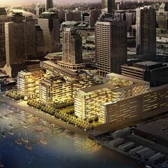
In plan, the three buildings extend the north/south pier-like directionality of the earlier phase that's to the south of them, they align to maintain views of the lake when seen from the Quay, and two of them are about the same height as the earlier phase. The two "tabletop" east/west sections of the earlier phase are set at jaunty angles to the buildings they float above, and the three new buildings take their angular cues from that - so it all ties together quite nicely. Rather than seeking validation for what designers do here by comparing the development to what some other designer of some other building in some other part of the world does, all we have to do is reference the earlier phase of the same project to see the connection.
 
Even if this has been done elsewhere in the world, this is a shockingly bold design for the Toronto waterfront. I just hope that the towers are a different colour from the shorter buidlings by the lake. That way, the horizontal sections won't be camoflauged.
 
7, 15, 25R, 29 and 39 Queens Quay E – Official Plan Amendment and Rezoning - Preliminary Report

This application proposes to construct three mixed use buildings containing retail at grade
and residential above at 7, 15, 25R, 29 and 39 Queens Quay East. The easterly buildings
will have heights of 13 storeys each and the westerly building will have a height of 35
storeys, with a combined total of 614 dwelling units.

This is the second phase of a development
of a total of seven buildings and public
open space located along the Yonge Street
Slip and the water’s edg
 
Thanks. Bad massing, fit w/ context and design in my books.

AoD

What context? As of now, there is no waterfront, it consists of a run-down restaurant on a boat, a sugar factory, and some barren lands that WT is so secretive about (bayside, see east bayfront forum). This project is setting the trend for the waterfront, creating a previously non-existent said "context". Personally, I think the waterfront is going in the right direction with the arrival of these renderings. But hey, we're all entitled to our own opinions.
 
Thanks. Bad massing, fit w/ context and design in my books.

AoD

I'd agree with you if the tower was on the eastern portion of the site, but its located on the northwest corner of the site, right at Yonge and Queens Quay. It's immediately adjacent to The Star office building, the Westin Harbour Castle and kitty corner to Pinnacle. That's its context. The tower relates to the high rise context to the west and the mid rise component of the development relates to the future/planned mid rise context to the east. That's how I see it anyways.
 
Quite right, and I would consider the Star office building, Westin Harbour Castle and the ilk to be the worst examples of mistakes on the waterfront. Personally I'd prefer to see highrises restricted to north of QQ, with the focus on creating a strong continous podium along the street.

AoD
 
Quite right, and I would consider the Star office building, Westin Harbour Castle and the ilk to be the worst examples of mistakes on the waterfront. Personally I'd prefer to see highrises restricted to north of QQ, with the focus on creating a strong continous podium along the street.

AoD

With that in mind, would you like then to see the tower on the Pier 27/Waterlink sight fit in with these "mistakes on the waterfront"?

Don't think so...
 
Thanks. Bad massing, fit w/ context and design in my books.

AoD

As a detractor of this particular project, I agree. Highrises should be north of Queens Quay, parks, and low-rise public and semi-public uses (ie private entertainment and commercial uses) should be on the south side.

But I am noticing something interesting with the shift in public space. I'm wondering if this constitutes an improved public realm.

I still strongly oppose the mostly single-use zoning and private cul-de-sacs that are also common to Harbour Square, no matter how interesting the architecture may be.

It is also disappointing that the OMB allowed this development in the first place against the Official Plan (the land is zoned for parkland) and the Committee of Adjustment.
 
Last edited:
It think this project is a real mixed bag.

I think one of the plan's main virtues lies in the bold, clear sightlines maintained between the length of the buildings from Queen's Quay to the water's edge. It looks like there was a determined effort here not to repeat the mistakes of Harbour Square and it's oppressive parking garage that blocks both views and circulation.

You have to wonder though, how the friendly and democratically open the buildings will feel at ground level. It was clear in earlier renders of the first two building sets, that the two outer courts between their flanking buildings would be more or less private space, blocked from through access from street to lake at ground level. Most of the open space in them would have been used for surface parking, pools, courtyards, etc. The only direct through passage for non-owner pedestrians would be down the centre passage. The impressive open sightlines were not as open as they were made out to be.

This new rendering does not (to me) show the ground level single-storey connecting structures from the first rendering. This is a good thing if true. But, the ground space between the buildings is stil generally taken up with parking access, cul-de-sacs, and sidewalks that may or may not reach the boardwalk running alongside and off of parking lots. Even the main central passage between the buildings has a massive parking intake running through it, and obliquely off it. This is not being made to look like inviting, entertaining living outdoor space. In fact, it feels a little bit cynical - ostensibly open spaces designed to make people confused about whether they are in the public or private realm, trespassing or welcome.

Although I generally support the big north-south spaces between the buildings, I think if there's another problem with them being so simplistically handled at the Queen's Quay's end. Although we really don't want or need another Harbour Square-type colossus on our hands, I wonder if the podium-space-podium-space-podium etc., setup along Queen's Quay is the best way to handle the streetwall? If all the courts between buildings were going to be guaranteed public access from front to back, I'd say we were onto something possibly quite interesting and enlivening. Since the plans have shown that it's likely that the outer two courts are likely to be more private space - with the attendent manicuring, fencing and stillness that accompanies such space, I worry the arrangement could be a bit deadening. Maybe if the semi-private spaces between the buildings can be put to good commercial use, it will help. A lot will depend on the final version of the landscaping, type and extent of commercial uses at ground level, and overall access.

I don't know about how the novelty of the architectural showiness will turn out. It looks like its busy being jagged and zany just to try and jazz itself up. A bit too clumsy and repetitious to really be fun, especially in the tall tower. It doesn't look like it has the sleek sculptual austerity of, say, Saucier & Perrotte's plan for the Don Lands. Stil, it's not over until it's over, and it could be at least an unexpected range of unusual and abnormal accents along the waterfront. That said - I hope the detailing is good.
 
Last edited:
I asked this in the blogpost but I think I have a better chance at it being answered here in the forum:

Has the city made a land exchange with the developers? It appears that this new site plan has more space between the property line and the Yonge St. slip. In addition, the parking lot where this new tower is being constructed belongs to the city.

My main objection to this development was that it was eliminating the possibility of a park or building at the foot of Yonge St. celebrating Toronto's center defining "spine". It seems as though enough room will be left intact to enable a future city project to do just that.
 
It is also disappointing that the OMB allowed this development in the first place against the Official Plan (the land is zoned for parkland) and the Committee of Adjustment.

That's not true for a couple of reasons. First the lands weren't designated parkland because the current Official Plan didn't apply to the site at the time of the hearing (it was grandfathered under the old official plan). Secondly, it wasn't really the OMB that allowed the development, IIRC it ended up being a settlement hearing with the City on side with the development.

I do agree though that it would have been nice to have more of the site open to the general public rather than fenced in, so to speak.
 
Has the city made a land exchange with the developers? It appears that this new site plan has more space between the property line and the Yonge St. slip. In addition, the parking lot where this new tower is being constructed belongs to the city.

My main objection to this development was that it was eliminating the possibility of a park or building at the foot of Yonge St. celebrating Toronto's center defining "spine". It seems as though enough room will be left intact to enable a future city project to do just that.

MetroMan,

In fact the answer to your question is YES, the city and the developers did work out an exchange of land. If you compare the drawings below, I believe that the City now owns all of the areas that are labeled Public Promenade along both the harbour and the slip, and that in return the developers now have the portion of the area labeled WATERFRONToronto Land that lies immediately behind the first phase building. The City's strip of land is now 46 metres wide running down to the harbour from Queens Quay, and the boardwalk running east as far as the Redpath property will be 25 metres wide. The public will also have access to the lake through the middle of the site down the Freeland Street extension. You can see other tweaks to the site plan, including both the road layout and orientation of some of the original phase buildings, in the new plan below.

OLD

OldPier27Property.jpg


NEW

Pier27Situation.jpg


42
 
Last edited:

Back
Top