News   May 09, 2024
 468     0 
News   May 09, 2024
 794     1 
News   May 09, 2024
 538     0 

Toronto Urban Sprawl Compared to Other Cities

That article confirms a trend that I've noticed within our gwneration. My brother and four of my cousins all don't drive. One of my cousins has her license but has only driven once or twice since she got it. The rest of them never even bothered getting their G1s. I also have a bunch of friends who don't have their licenses. That said, while they're all well educated, I've seen how their not driving affects their marketability when trying to find employment. I'm not happy with how auto-centric my life is, and I'll be moving right next to a rail line very soon, but the reality is that in order to prosper, you need to at least have the option of driving available to you.
 
That article confirms a trend that I've noticed within our gwneration. My brother and four of my cousins all don't drive. One of my cousins has her license but has only driven once or twice since she got it. The rest of them never even bothered getting their G1s. I also have a bunch of friends who don't have their licenses. That said, while they're all well educated, I've seen how their not driving affects their marketability when trying to find employment. I'm not happy with how auto-centric my life is, and I'll be moving right next to a rail line very soon, but the reality is that in order to prosper, you need to at least have the option of driving available to you.

The recession hasn't helped, either. The under-employed/intern generation would have a hard time affording car ownership. Likewise, more and more of us are living with our parents.

I don't see any real evidence amongst my generation that *preferences* have changed... In some abstract sense I'm sure most of us would like to have a car. But, like all humans, we're also rational people who react to our circumstances. Rising costs of car ownership and declining incomes are definitely squeezing people out.

I'd be curious if boom states like North Dakota have witnessed a noticeable change in driving behaviour...
 
I wouldn't go that far, most people would be getting their licences if they hoped to eventually own a car. However, *because* cars are expensive, as well as other reasons, many choose simply not to deal with it and just take public transit.

That said, I got my G by the time I started university and while I have no car right now I completely agree that having your G is key for jobs, I always notice when looking for summer employment that probably roughly half the jobs I look at are looking for someone with a full license. you shut a lot of doors without one, even if you don't personally own a car.
 
I've compared Toronto and Chicago in my latest blog post.

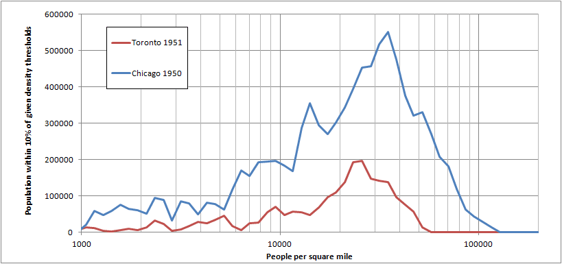
In 1950 Chicago was a much bigger city. The average density was not hugely different, though it was higher in Chicago and Chicago had quite a bit more very high density (>20,000 p/km2 or so) while Toronto basically had none.
1950+Chi+To+total.png


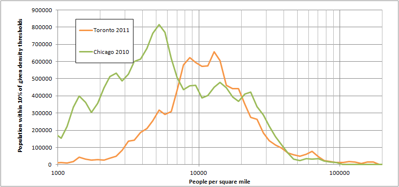
Going forward to 2010, Chicago builds suburbia that is less dense than Toronto's and loses population within the core. Toronto's most common densities (probably largely suburban) at around 4000/km2 are comparable to lower density urban neighbourhoods in Chicago.
2010+Chi+To+total.png


More here: http://swontariourbanist.blogspot.ca/2014/03/toronto-and-chicago-density-comparison.html

I also have an earlier blog post mapping how Chicago, Philadelphia, Montreal, Baltimore, Cincinnati and New Orleans' population changed from 1950 to 2010 within city limits.
http://swontariourbanist.blogspot.ca/2014/03/more-1950-to-2010-comparisons.html

I'm thinking of mapping post-WWII population change for Ontario cities as one my next posts. Windsor, London, Ottawa and Toronto have 1951 data. Kitchener-Waterloo only have census tract data from 1956 onwards. Hamilton should have 1951 data but I've only been able to find 1956 data so far, so maybe I'll compare 1956 to 2011 instead of 1951 to 2011.

Shouldn't Y axis be % of population or something like that? Chicago has almost twice the population of Toronto. The population needs to be standardized somehow.

Still interesting graphs though, if you keep in themind the size difference between the two cities.
 
Shouldn't Y axis be % of population or something like that? Chicago has almost twice the population of Toronto. The population needs to be standardized somehow.

Still interesting graphs though, if you keep in themind the size difference between the two cities.

Incorrect about the population.

[h=1]Toronto’s population overtakes Chicago[/h]
See link from 2013:

Since Toronto was amalgamated in 1998, it has billed itself as North America’s fifth largest city after Mexico City, New York, Los Angeles and Chicago.

But according to the latest census data from Statistics Canada, as of last July 1, Toronto’s population was 2,791,140, about 84,000 more than Chicago’s 2,707,120.
 
In some abstract sense I'm sure most of us would like to have a car. But, like all humans, we're also rational people who react to our circumstances. Rising costs of car ownership and declining incomes are definitely squeezing people out.

I disagree. From my own experience I can say that young people around me don't want cars largely because it's seen as an extra hassle. Also many are fine with taking public transit. The TTC is 'good enough' and the hassles/responsibilities of car ownership aren't worth the trouble. Even among the teens that do want a car, it's merely something that is nice to have. A pie in the sky dream that is more or less dead last on the list of their priorities. Of course I live went to school downtown and attitudes may be different further from the core, though I haven't really noticed much difference.

This is a topic that has been covered extensively in the media. Auto makers are definitely noticing that younger people aren't buying cars. They fear that if they don't get people into cars early in life, they'll never buy one. I feel like the "problem" may be exacerbated in Toronto since our city is already incredibly public transit oriented (when compared to other NA cities) and there isn't the large stigma associated with taking public transit that can be seen in many American cities.


I don't see any real evidence amongst my generation that *preferences* have changed...

There's plenty of evidence. In 2011 fewer than 51% of American young people were licensed, compared to 72% in the 1980s. I'm confident that this number will be lower than 50% in 2014. This includes American young people in urban, suburban and rural environments. I'm sure that if this were done only in urban areas the number would be even lower. I can't find any information for Toronto specifically, but given how transit oriented the city is, I wouldn't be surprised if less than a third or even quarter of young people in the city are licensed. It's pretty clear to me that young people are rejecting the suburban, auto-oriented lifestyle.

74518_600x450-cb1387302373.jpg
 
Incorrect about the population.

[h=1]Toronto’s population overtakes Chicago[/h]
See link from 2013:

This was for the urban areas though, in which case Chicago is in fact almost double. In 1950 it was about 4x the population. Anyways, the main point of the first graph was to show that Chicago had a lot more high density in 1950, but that a big part of the reason for that was that it was much bigger (though it was still denser on average). The purpose of 2010 graph is to show that despite the population difference, Toronto now has a comparable amount of high density, with the difference in population being in the form of more low density for Chicago. Basically, Toronto closed the gap.

My blog post also has comparisons that have the two cities normalized for population, as well as putting the 1950 and 2010 distributions on the same graph to better show how they changed during that time.
http://swontariourbanist.blogspot.ca/2014/03/toronto-and-chicago-density-comparison.html

As for drivers licenses, most of my friends in Oakville got their ASAP, although a few delayed it by a year or two (like me). I could imagine that it would be quite a bit different in Toronto's core though.
 
Chicago's population numbers are coming from the US version of the CMA which is much more loose. If it were to be applied to Toronto, we would only be around 1,000,000 people short, if not less.
 
Chicago's population numbers are coming from the US version of the CMA which is much more loose. If it were to be applied to Toronto, we would only be around 1,000,000 people short, if not less.
No they're not... these are my numbers and they're for the Chicago Urban Area which has 9 million people to Toronto's 5.2 million.

Toronto using the US version of CMAs (MSAs) would still be quite a bit smaller than Chicago. MSAs are based on commuting patterns, and while their criteria are more generous than StatsCan's, you'd still end up with a lot less.

Chicago's MSA has about 9.5 million people.

Toronto's MSA would definitely have the whole GTA, plus Dufferin County. Using the 2006 census commuting numbers, that's it, Hamilton would be separate (similar to how Worcester is separate from Boston and at a similar distance). Using the 2011 National Household Survey, Kawartha Lakes would also qualify for the MSA, which requires 25% commuting into the core counties (which would be the GTA). Kawartha has 27%, so they're good. Hamilton has 24% so it just barely falls short. So you'd get around 6.1-6.2 million for the MSA.

Even if you want to be generous and add Hamilton despite the fact that it falls 1% short, which would make Hamilton a core county (since it's continuously urbanized with Toronto), and which would allow Haldimand to be part of the MSA too, since over 25% commute into Hamilton which would now be a core county. And then on top of that you broke down Simcoe County into a Southern and Northern half (since it's a very big county by US standards), which would allow the southern half to join Toronto's MSA (whole county can't with only 20% commuting into the GTA), that still gives you only about 6.9-7.0 million. So 2.5 million short of Chicago.

For the CSA, you'd have around 7.4 million using the 2011 NHS commuting patterns. Maybe 7.5 million if Hamilton is part of the MSA since that would allow you to add Brant County. Chicago would be 9.8-9.9 million.

To get to less than 1 million from Chicago, you'd have to add Wellington, Waterloo and Niagara Region, and then some (from where? Oxford County? Norfolk?). For Niagara and Waterloo Regions, it's still pretty low. Wellington it's high enough to qualify for the Toronto CSA, but it's more closely tied to Waterloo Region for commuting, and a city can only be in one CSA, so Wellington would go to Waterloo. Even you are supergenerous though, and add Wellington and Brant to the CSA, that's still just 7.7 million, more than 2 million short of Chicago.

You can't just say that because Chicago's CSA should cover x square miles, so should Toronto's. That's a double edged sword that would also allow Boston to baloon to 8.5 million, Miami to 9 million (stretching 500km to Daytona Beach, since it would be a narrow strip), Washington to 9.5 million, San Francisco to 10 million, Philadelphia to over 10 million... And to take it global, Shanghai might have 50 million, as would Delhi and Guangzhou. Or Al Mahallah Al Kubra in Egypt (population 450,000) is actually part of a metro area of 10 or 15 or 20 or 25 million... Because the Nile Delta is composed of towns of 10-20,000 p/km2 that are very close together, so you have densities of 3,000-5,000 p/km2 across much of the Delta, which holds about 30 million people if you exclude Cairo and Alexandria (located at the edge of the Delta region). And in this 30 million person region, Al Mahallah Al Kubra is the biggest city, but no-one would seriously contend that it's bigger than Toronto, or Chicago, or hell, New York, because the Nile Delta holds more people in the same amount of land area that these metro areas take up.

And by the way, Chicago doesn't need those 28,000 km2 (MSA land area) to be a big city. The urban area holds 8.9 million out of the 9.5 million MSA in just 5,500km2. So most of the MSA is just farmland that doesn' contribute much to the population.

The GTA by comparison is 7,100 km2. You could tweak the boundaries of the GTA, remove Brock, Scugog, Uxbridge, Georgina to make room for Hamilton or what not, but you'll still be around 6.5 million for a comparable 5,500km2 land area.

This is how some Canadian MSAs/CSAs would look based on 2006 census commuting patterns.
http://forum.skyscraperpage.com/showthread.php?p=6058472#post6058472
 
Last edited:
I've compared Toronto and Chicago in my latest blog post.

In 1950 Chicago was a much bigger city. The average density was not hugely different, though it was higher in Chicago and Chicago had quite a bit more very high density (>20,000 p/km2 or so) while Toronto basically had none.
1950+Chi+To+total.png


Going forward to 2010, Chicago builds suburbia that is less dense than Toronto's and loses population within the core. Toronto's most common densities (probably largely suburban) at around 4000/km2 are comparable to lower density urban neighbourhoods in Chicago.
2010+Chi+To+total.png


More here: http://swontariourbanist.blogspot.ca/2014/03/toronto-and-chicago-density-comparison.html

I also have an earlier blog post mapping how Chicago, Philadelphia, Montreal, Baltimore, Cincinnati and New Orleans' population changed from 1950 to 2010 within city limits.
http://swontariourbanist.blogspot.ca/2014/03/more-1950-to-2010-comparisons.html

I'm thinking of mapping post-WWII population change for Ontario cities as one my next posts. Windsor, London, Ottawa and Toronto have 1951 data. Kitchener-Waterloo only have census tract data from 1956 onwards. Hamilton should have 1951 data but I've only been able to find 1956 data so far, so maybe I'll compare 1956 to 2011 instead of 1951 to 2011.


I'm glad you started a blog. I like your work memph :)
 
No they're not... these are my numbers and they're for the Chicago Urban Area which has 9 million people to Toronto's 5.2 million.

Toronto using the US version of CMAs (MSAs) would still be quite a bit smaller than Chicago. MSAs are based on commuting patterns, and while their criteria are more generous than StatsCan's, you'd still end up with a lot less.

Chicago's MSA has about 9.5 million people.

Toronto's MSA would definitely have the whole GTA, plus Dufferin County. Using the 2006 census commuting numbers, that's it, Hamilton would be separate (similar to how Worcester is separate from Boston and at a similar distance). Using the 2011 National Household Survey, Kawartha Lakes would also qualify for the MSA, which requires 25% commuting into the core counties (which would be the GTA). Kawartha has 27%, so they're good. Hamilton has 24% so it just barely falls short. So you'd get around 6.1-6.2 million for the MSA.

Even if you want to be generous and add Hamilton despite the fact that it falls 1% short, which would make Hamilton a core county (since it's continuously urbanized with Toronto), and which would allow Haldimand to be part of the MSA too, since over 25% commute into Hamilton which would now be a core county. And then on top of that you broke down Simcoe County into a Southern and Northern half (since it's a very big county by US standards), which would allow the southern half to join Toronto's MSA (whole county can't with only 20% commuting into the GTA), that still gives you only about 6.9-7.0 million. So 2.5 million short of Chicago.

For the CSA, you'd have around 7.4 million using the 2011 NHS commuting patterns. Maybe 7.5 million if Hamilton is part of the MSA since that would allow you to add Brant County. Chicago would be 9.8-9.9 million.

To get to less than 1 million from Chicago, you'd have to add Wellington, Waterloo and Niagara Region, and then some (from where? Oxford County? Norfolk?). For Niagara and Waterloo Regions, it's still pretty low. Wellington it's high enough to qualify for the Toronto CSA, but it's more closely tied to Waterloo Region for commuting, and a city can only be in one CSA, so Wellington would go to Waterloo. Even you are supergenerous though, and add Wellington and Brant to the CSA, that's still just 7.7 million, more than 2 million short of Chicago.

You can't just say that because Chicago's CSA should cover x square miles, so should Toronto's. That's a double edged sword that would also allow Boston to baloon to 8.5 million, Miami to 9 million (stretching 500km to Daytona Beach, since it would be a narrow strip), Washington to 9.5 million, San Francisco to 10 million, Philadelphia to over 10 million... And to take it global, Shanghai might have 50 million, as would Delhi and Guangzhou. Or Al Mahallah Al Kubra in Egypt (population 450,000) is actually part of a metro area of 10 or 15 or 20 or 25 million... Because the Nile Delta is composed of towns of 10-20,000 p/km2 that are very close together, so you have densities of 3,000-5,000 p/km2 across much of the Delta, which holds about 30 million people if you exclude Cairo and Alexandria (located at the edge of the Delta region). And in this 30 million person region, Al Mahallah Al Kubra is the biggest city, but no-one would seriously contend that it's bigger than Toronto, or Chicago, or hell, New York, because the Nile Delta holds more people in the same amount of land area that these metro areas take up.

And by the way, Chicago doesn't need those 28,000 km2 (MSA land area) to be a big city. The urban area holds 8.9 million out of the 9.5 million MSA in just 5,500km2. So most of the MSA is just farmland that doesn' contribute much to the population.

The GTA by comparison is 7,100 km2. You could tweak the boundaries of the GTA, remove Brock, Scugog, Uxbridge, Georgina to make room for Hamilton or what not, but you'll still be around 6.5 million for a comparable 5,500km2 land area.

This is how some Canadian MSAs/CSAs would look based on 2006 census commuting patterns.
http://forum.skyscraperpage.com/showthread.php?p=6058472#post6058472


you would start to look at having K-W in the Toronto MSA as well, which is where I get my number.
 
you would start to look at having K-W in the Toronto MSA as well, which is where I get my number.

It's not justified though. Both K-W and Niagara Region have little commuting into Toronto. Even for CSA it's not enough, and CSA criteria are much more generous than MSA.

Waterloo residents' place of work

GTA: 1,350
Wellington: 1,450
Hamilton: 125
Waterloo Region: 40,070
Other: 675
Total: 43,670

Kitchener is a bit more connected, their place of work is

GTA: 3,560
Wellington: 5,765
Hamilton: 415
Waterloo Region: 86,760
Other: 1,635
Total: 98,135

Still that's well short of what it would have to be to be part of Toronto's CSA, like well well short, it's only 3.6% working in the GTA while it would have to be 25% to qualify for CSA.

Cambridge:

GTA: 5,540
Wellington: 5,185
Hamilton: 930
Waterloo Region: 41,270
Other: 1,365
Total: 54,290

K-W-C
GTA: 10,450
Total: 196,095

So 5.3% compared to the 25% it needs to be part of the MSA. For the CSA, you'd add that 5.3% to the percent of K-W-C jobs held by GTA residents.

Cambridge
GTA: 1,865
Total: 57,025

Kitchener
GTA: 1,655
Total: 80,645

Waterloo
GTA: 3,085 (was a little surprised to see this as the highest, I guess there's something to the stories of GTA residents commuting to RIM)
Total: 63,265

K-W-C
GTA: 6,605
Total: 200,935

So despite RIM, it's still just 3.3% of GTA residents commute into K-W-C. 3.3+5.3 = 8.6, which is still quite a bit short from the 15 you'd need for combining the two into a CSA.

Maybe if Wellington County (and Hamilton) could qualify for Toronto's MSA, that would be enough to pull in K-W-C.

Guelph commuters work in...
GTA: 5,575
Hamilton: 610
Total: 48,325

But Guelph is still quite a bit short, with 12.8% commuting into the GTAH and 11.5% commuting into the GTA (Hamilton almost qualifies as a core county).

I haven't bothered checking the more rural census subdivisions (Erin, Pusclinch, North Dumfries, Woolwich, etc), but I doubt they would tip the scales, since it's not even close.

Btw, just to review the definitions for MSAs/CSAs:


Core County: A county where the majority of the population lives in the CSA's primary urban area. I'm assuming that Burlington and Oakville are part of the same urban area, even though Statscan says otherwise, ditto for Oshawa. I'm also pretty sure core counties also need to have 25% of residents commuting into the other core counties, and that this is why Santa Clara County (San Jose) is separate from the SF-Oakland MSA.

Outlying County: A county with 25% of residents commuting into the core counties, but where the majority of the population does not live in the main urban area (ex Dufferin County).

MSA: Core Counties + Outlying Counties

CSA: If there is a 15% commuter exchange between two MSAs, they can combine. However, I think (not positive though) the smaller MSA can only combines with one MSA, and it joins the one with the highest commuter exchange. So for Guelph, that's Waterloo Region instead of the GTA, and for Hamilton, it's the GTA instead of Brantford. Also, in order for there to be an MSA, you need an urban area of at least 10,000 people. If not, the county is too rural to form an MSA and cannot join the CSA.

So for Toronto, I think it would be

Core Counties:
Toronto
York
Peel
Halton
Durham

Outlying Counties
Dufferin
Kawartha Lakes

CSA Counties
Northumberland
Peterborough
Simcoe
Hamilton
Haldimand (an outlying county of Hamilton's MSA)
 
Last edited:
I disagree. From my own experience I can say that young people around me don't want cars largely because it's seen as an extra hassle. Also many are fine with taking public transit. The TTC is 'good enough' and the hassles/responsibilities of car ownership aren't worth the trouble. Even among the teens that do want a car, it's merely something that is nice to have. A pie in the sky dream that is more or less dead last on the list of their priorities. Of course I live went to school downtown and attitudes may be different further from the core, though I haven't really noticed much difference.

This is a topic that has been covered extensively in the media. Auto makers are definitely noticing that younger people aren't buying cars. They fear that if they don't get people into cars early in life, they'll never buy one. I feel like the "problem" may be exacerbated in Toronto since our city is already incredibly public transit oriented (when compared to other NA cities) and there isn't the large stigma associated with taking public transit that can be seen in many American cities.


There's plenty of evidence. In 2011 fewer than 51% of American young people were licensed, compared to 72% in the 1980s. I'm confident that this number will be lower than 50% in 2014. This includes American young people in urban, suburban and rural environments. I'm sure that if this were done only in urban areas the number would be even lower. I can't find any information for Toronto specifically, but given how transit oriented the city is, I wouldn't be surprised if less than a third or even quarter of young people in the city are licensed. It's pretty clear to me that young people are rejecting the suburban, auto-oriented lifestyle.

74518_600x450-cb1387302373.jpg


With less young people driving, developers should build for the transit user, bicycle riders, and walking people. However, they still have a mindset towards the automobile. It will take more decades before developers and politicans change, unfortunately.
 
With less young people driving, developers should build for the transit user, bicycle riders, and walking people. However, they still have a mindset towards the automobile. It will take more decades before developers and politicans change, unfortunately.
...and car commercials take up approximately one in every five commercial slots on almost any given channel (save for commercial-free channels and child-oriented channels).
 

Back
Top