News   May 09, 2024
 484     0 
News   May 09, 2024
 807     1 
News   May 09, 2024
 543     0 

Toronto Urban Sprawl Compared to Other Cities

Places like this should be outlawed. Unless these families are working a homestead nearby or have employment within 10km this just should be allowed.

While this may be a little hyperbolic sometimes I just wish the state would kick people like this out of their homes and relocated them closer to society.
 
A couple US comparisons. I doubt I got all of the US urban areas in though, due to my lack of geographical knowledge about them and the fact that some of the residential areas are very low density and from the scale I had to isolate them it looked uninhabited.

12464967583_9144f6a52f_b.jpg


FULL SIZE

FYI: You may think that I made a mistake with New York leaving all that green, but this is what it looks like when zoomed in. SPRAAAAAWWWWWL.

12464820005_cca53894af_b.jpg
You can try expanding the image to make room for Atlanta, Boston, and Phoenix.
 
You can try expanding the image to make room for Atlanta, Boston, and Phoenix.

Thought about it. Atlanta I pretty much already have, just need to adjust the scale. Boston is a pain since it thins out to the point where it is VERY hard to tell if something is suburban or rural from the scale I need it to be so I can isolate it. With Phoenix the problem is that from that large a scale it's kind of hard to see the brown-grey contrast since the colours are so similar, and again a lot of the suburbs are such low density that they look like the desert from far away.

Also, this took a while to do and I got lazy.
 
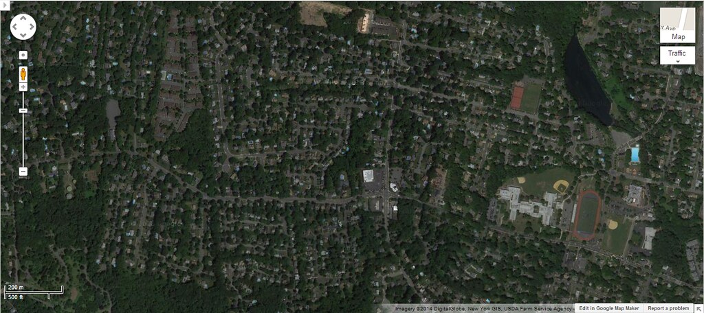
These communities deserve to have their oil supply cut off.
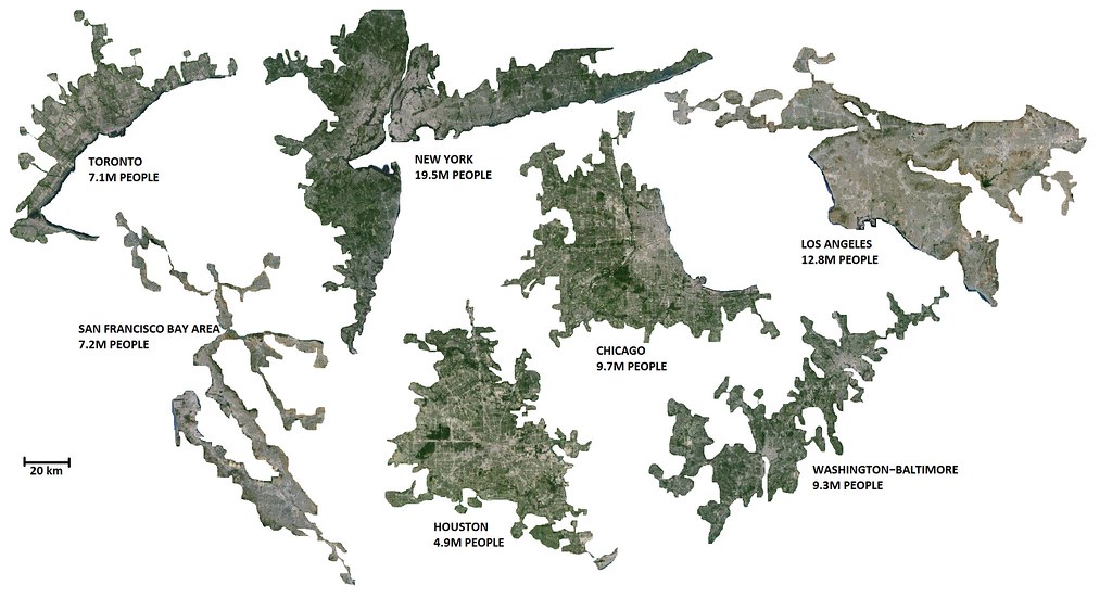
Places like this should be outlawed. Unless these families are working a homestead nearby or have employment within 10km this just should be allowed.

While this may be a little hyperbolic sometimes I just wish the state would kick people like this out of their homes and relocated them closer to society.

LOL
Who are you to say how and where someone should live? Gimme a goddamn break with yours "megahouse in suburbs are evil!!!1111".
 
The problem with areas like new york is that they never really end... they just sort of morph into the next city. New York Becomes Newark which becomes Trenton which becomes Philidelphia, New York becomes Stamford which becomes Bridgeport which becomes Hew Haven which becomes Hartford
 
US City Region Sprawl Maps as compared with Toronto...

A couple US comparisons. I doubt I got all of the US urban areas in though, due to my lack of geographical knowledge about them and the fact that some of the residential areas are very low density and from the scale I had to isolate them it looked uninhabited.

12464967583_9144f6a52f_b.jpg


FULL SIZE


FYI: You may think that I made a mistake with New York leaving all that green, but this is what it looks like when zoomed in. SPRAAAAAWWWWWL.

12464820005_cca53894af_b.jpg

MJ: The 6 US metropolitan regions that you posted look correct...

I especially noticed the NY-NJ area and I believe that I reside about half way out on Long Island to the E and the area of New Jersey that is shown
is definitely the areas and counties considered to be part of the New York region...

Where is the NY-NJ area map section that you posted located?

The map of Chicagoland shows that sprawling region - for comparison the City boundary should be added to show how much growth has occurred outside the City...

The Baltimore-Washington area is interesting because what the growth in Maryland between the cities shows (they are 40 miles apart-similar to Toronto-Hamilton)
that the two once-separate areas have become one region in the past 40-50 years...

Houston and Los Angeles as many know are primarily auto-centric cities that have large amounts of medium density sprawl as well as a older high-density Downtown area in LA...

I would like to see more of these renderings - they very much interest me...LI MIKE
 
Last edited:
I expected LA to me a lot bigger with all their sprawl.

LA and Toronto are probably the densest metros in North America. LA probably doesn't deserve a reputation for sprawl as much as it deserves a reputation for car-orientedness. While there are very dense neighbourhoods in LA - some as dense as anything south of Bloor street - they are still lousy places to walk, with most of the arterials being designed to move cars in and out quickly.

This is a good example. The surrounding neighbourhood is probably no less dense than the Annex (maybe more), but the arterial is 4 lanes of traffic (no parking) with few opportunities to cross the street. Most of the retail still has parking lots in front.
 
I would agree. I use to live in the area of W 6th & La Brea and it was extremely dense and almost impossible to find street parking.
 
Quick note, the population for DC is wrong. It was pointed out to me at SSP that the urban population as shown is 6.7M. I used the MSA population which includes some rural obviously. Also I used the MSA population for LA, but apparently I outlined pretty much the entire CSA. Population as shown is probably closer to 17M.

The problem with areas like new york is that they never really end... they just sort of morph into the next city. New York Becomes Newark which becomes Trenton which becomes Philidelphia, New York becomes Stamford which becomes Bridgeport which becomes Hew Haven which becomes Hartford

Exactly. NY was a toughy. I purposely stuck to the MSA, because otherwise it would've been way too hard to judge where to draw the line. Include the suburbs just north in CT, might as well include Springfield/Hartford, in which case I might as well have included Providence, and then Boston. They're all connected. Further, Philly and NY are one. I figured sticking to the MSA is the easiest way out of the dilemna.

MJ: The 6 US metropolitan regions that you posted look correct...

I especially noticed the NY-NJ area and I believe that I reside about half way out on Long Island to the E and the area of New Jersey that is shown
is definitely the areas and counties considered to be part of the New York region...

Where is the NY-NJ area map section that you posted located?

The map of Chicagoland shows that sprawling region - for comparison the City boundary should be added to show how much growth has occurred outside the City...

The Baltimore-Washington area is interesting because what the growth in Maryland between the cities shows (they are 40 miles apart-similar to Toronto-Hamilton)
that the two once-separate areas have become one region in the past 40-50 years...

Houston and Los Angeles as many know are primarily auto-centric cities that have large amounts of low-medium density sprawl...

I would like to see more of these renderings - they very much interest me...LI MIKE

That map section was zoomed in at the northernmost green section.

I did renderings for Canada's cities as well. I posted it a page or two before this one. Canada's cities are far more contained. We seem to have a pretty low tolerance for exurbs. SF and LA are limited by their geographical constraints, otherwise they would've sprawled further, and even with those constraints, they're still less dense than Toronto.

A note about Houston: I didn't realize much of the sprawl is right on the ocean. Kind of weird that the city was built that far inland when settling 20km south would've given much easier ocean access.
 

Back
Top