


| NEWS | DATABASE | MAP | FORUM | DASHBOARD |  | SERVICES | UTPro | LOG IN | CITIES |
|
|
| |||||||||||||||||||||
| |||||||||||||||||||||||
Toronto Union Subway Station: Second Platform and Concourse Improvements | ?m | ?s | TTC | Arcadis
yyzhyd
Active Member
Hope once it's done they'll replace those with nice mature London Plane's like they put in up on Bloor St.
androiduk
Senior Member
.

nfitz
Superstar
Construction has now started on the surface.
And Ellis Don has added a page to their website - http://ascribehq.com/ellisdon/portfolio/5925
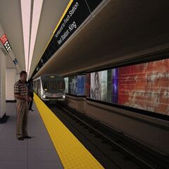
With an interesting image:

It lists the architect and the mechanical engineer:
Architect: Richard Stevens Architect Ltd.
Mechanical: AECOM
And Ellis Don has added a page to their website - http://ascribehq.com/ellisdon/portfolio/5925
With an interesting image:
It lists the architect and the mechanical engineer:
Architect: Richard Stevens Architect Ltd.
Mechanical: AECOM
khris
Senior Member
Is the new platform north of the existing one?
What is the this pedestrian corridor for GO riders to bypass TTC's paid area?
What is the this pedestrian corridor for GO riders to bypass TTC's paid area?
A sight not seen in downtown for decades... Work being done improving the subway system in the downtown core. If this was a picture of the start of the DRL, I'd be tempted to go down there and crack open a bottle of champagne. But alas, it isn't. However, it's still a great sight to see!
nfitz
Superstar
No, to the south. Essentially the existing platform will be glass-walled off along the south, and will only access the Downsview-bound trains. The new platform will built along the south and will access the Finch-bound trains, and also connect to the existing LRT platform. There's an image on Steve Munro's website. The new stuff is all in turquoise:Is the new platform north of the existing one?

Currently you can walk through the TTC subway station down the middle and not have to pay a fare to get to the Royal Bank Plaza. From this other image from Steve's website, it looks like there will be a second way through the station without paying, from the teamway along the west side of Bay Street, through the station, and then around to the Royal Bank Plaza, or to the BCE building. Here is the image, but this time the turquoise is the fare-paid area:What is the this pedestrian corridor for GO riders to bypass TTC's paid area?

Jonny5
Senior Member
Currently you can walk through the TTC subway station down the middle and not have to pay a fare to get to the Royal Bank Plaza. From this other image from Steve's website, it looks like there will be a second way through the station without paying, from the teamway along the west side of Bay Street, through the station, and then around to the Royal Bank Plaza, or to the BCE building. Here is the image, but this time the turquoise is the fare-paid area
The alternate route from the teamway you describe already exists and is really a rather roundabout way from the GO concourse to the path. The turquoise area at the far right is a completely new area.
This map implies there will be a tight pinch point where people can pass from the GO concourse, through the subway station and on to the PATH, without entering the fare paid area.
Last edited:
nfitz
Superstar
I was wondering about that after I posted. Can you get from Union to Royal without going through a fare-paid area? I can't quite picture it ... I always seem to not go that way.The alternate route from the teamway you describe already exists and is really a rather roundabout way from the GO concourse to the path. The turquoise area at the far right is a completely new area.
EnviroTO
Senior Member
This map implies there will be a tight pinch point where people can pass from the GO concourse, through the subway station and on to the PATH, without entering the fare paid area.
Hopefully after the moat is cut allowing access to the new lower level of Union Station the pinch point will not be as bad as the diagram suggests. The way it looks currently suggests it will be a real bottleneck. The stairs on the far left of the south entrance to the station from the moat has a closet under them which if remove would reduce the bottleneck significantly.
nfitz
Superstar
It certainly looks at though it would improve the flow from the subway station to Union Station itself. It's the flow from the Royal Bank Plaza to Union that looks impeded. Might end up simply being easier to come outside at Front/Bay and walk across the street. I wonder if that's the aim ...
Jonny5
Senior Member
It certainly looks at though it would improve the flow from the subway station to Union Station itself. It's the flow from the Royal Bank Plaza to Union that looks impeded. Might end up simply being easier to come outside at Front/Bay and walk across the street. I wonder if that's the aim ...
Maybe they are hoping the new PATH expansion under York will divert enough people out of this area to prevent a bottleneck.
I just noticed how there are no longer stairs in the far east of the fare paid area. It looks like they moved them to the east so they are now just east of the automatic entrance. This got me thinking how could Brookfiled Place be a few feet higher than the RBC when they are connected without any stairs through that north east corridor on the diagram. There must be some gentle slope in that hallway I don't remember. I guess that's what the arrow looking line in the middle of the corridor is indicating. It says something but the resolution is too low to make out. Otherwise this whole diagram is like an M C Escher design.
Last edited:
Dan416
Senior Member
Maybe they are hoping the new PATH expansion under York will divert enough people out of this area to prevent a bottleneck.
I just noticed how there are no longer stairs in the far east of the fare paid area. It looks like they moved them to the east so they are now just east of the automatic entrance. This got me thinking how could Brookfiled Place be a few feet higher than the RBC when they are connected without any stairs through that north east corridor on the diagram. There must be some gentle slope in that hallway I don't remember. I guess that's what the arrow looking line in the middle of the corridor is indicating. It says something but the resolution is too low to make out. Otherwise this whole diagram is like an M C Escher design.
There are much clearer versions of these diagrams on the Union redevelopment plan somewhere. I remember looking at them.
smallspy
Senior Member
There are much clearer versions of these diagrams on the Union redevelopment plan somewhere. I remember looking at them.
The TTC's own report, perhaps?
http://www3.ttc.ca/About_the_TTC/Co.../Dec_15_2010/Reports/Union_Station_New_Pl.pdf
By the way, if you look at the drawings appended to the report, you'll notice that there is no passenger flow chokepoint at the south-west corner of the mezzanine.
Dan
Toronto, Ont.
nfitz
Superstar
Good find ... I was searching through older TTC reports from when they approved the finishes. I never thought to check anything that recent!
Yes, looks like they've redesigned the western half of the mezzanine ... which should eliminate that potential chokepoint at the south-west corner.
I'm amazed I've never realized there is already that rotunda there that links to the Royal building and the teamway ... and has another line of gates to the subway (I assume). When was this added? I assume with the connection to BCE? I spent a lot more time in Union Station in the 1980s and early 1990s than I did until very recently.
(it's fascinating being back downtown a lot ... it's interesting in what has changed in 20 years ... big and little).


