Toronto Ontario Line 3 | ?m | ?s

Correct me if I'm wrong but Pape is totally residential. There's nothing to redevelop there while Carlaw actually does have redevelopment potential to complement the nearby neighbourhoods. I think that's what the report was heavily implying.

It's literally a 100m walk - no one is going to stop developing at Carlaw just because the station is on Pape.

AoD
 
Correct me if I'm wrong but Pape is totally residential.

And this can't be redeveloped? Yonge and Eglinton used to be the same before the Yonge subway came through. As were many other areas of the city once the subway arrived. There wouldn't be much growth if all we could build on were parking lots.
 
And this can't be redeveloped? Yonge and Eglinton used to be the same before the Yonge subway came through. As were many other areas of the city once the subway arrived. There wouldn't be much growth if all we could build on were parking lots.

Indeed - the whole thing is wrapped up on the "better fit" argument when it is in essence an unwillingness to disturb the status quo, added cost and complexity be damned.

AoD
 
Indeed - the whole thing is wrapped up on the "better fit" argument when it is in essence an unwillingness to disturb the status quo, added cost and complexity be damned.

AoD

Why would you destabilize any area, residential neighbourhood or not, if you could align your subway to fit into an existing higher-density corridor with development potential? Why aren't we aiming for better urban form?

I think this whole argument for staying on Pape is wrapped up in a demonization of single-family housing and some view that a curve in the subway line is a catastrophic concession.
 
TL;DR SUMMARY OF REPORT

CHOICE: + Carlaw follows existing Pape bus
Comment: Disrupting busy routes during construction is a positive now.

EXPERIENCE: Almost identical for both

SOCIAL EQUITY: "Social equity benefits are almost the same for both options."
Comment: Quick look on Maps showed there is a WoodGreen seniors home on Queen just east of Pape literally right up against the station entrance. YWCA and WoodGreen apartments on Pape. Zero ***** given by planners.

SHAPING THE CITY: + Carlaw is better because there's a small bachelor parking lot to develop at Queen.
Comment: The development potential of a single postage stamp sized parking lot is now being taken into account by professional planners.

HEALTHY NEIGHBOURHOODS: + Carlaw is better it is higher density
Comment: Planners made a huge deal about the Richmond/Adelaide-Sumach station "bridging the barrier" between neighbourhoods to justify bringing the line back to Queen from Eastern. Gerrard station would have did the same thing for this neighbourhood but it doesn't even get a footnote because planners are dishonest hypocrites. They also made a big deal about going down to Eastern/Unilever to protect against impacts to historic Queen Street east but now they're looking at knocking down a large and important local grocery store, a large local convenience store on Queen, and Kim's church with no mention of the resulting impacts to the neighbourhood from removing important local institutions or heritage buildings. (FYI They had picked the lower density corridor on Queen last round.)

PUBLIC HEALTH/ENVIRONMENT: + Carlaw = commercial/industrial uses not as impacted by noise/construction, fewer low-rise residential uses = lower impact to residents
Comment: There are 10 storey condos on Carlaw. They outnumber the NIMBY's on Pape. The needs of the many outweigh the needs of the few. Except when Toronto planners are involved.

AFFORDABILITY: - Carlaw has more utility conflicts and more disruption to transit. Much more expropriation needed.
Comment: Consistent with the city's choice to choose the more expensive and longer tunnel from Eastern to Queen.

Hilarious document. It highlights how reports just back up whatever pre-determined conclusions they wanted. The same items propped up as positives for the Carlaw vs Pape alignment also applied to King vs Queen but in the former case used as positives to justify rather than as a point for rejection (when not ignored). Just fire the overpaid consultants and planners and let the local councillor's office write these reports.

EDIT: Updated social equity section with new information
 
Last edited:
There's nothing that says Pape can't be redeveloped...

Actually, there is.

Screen Shot 2017-03-08 at 3.44.02 PM.png


In city planning, "stable residential area" means that the city intends to preserve the existing buildform and physical character of the neighbourhood, and that any new developments would have to respect that. Growth is instead directed along the "Avenues", which in this case would be Carlaw. You may disagree, but that's what the policy is.


Yonge and Eglinton used to be the same before the Yonge subway came through. As were many other areas of the city once the subway arrived. There wouldn't be much growth if all we could build on were parking lots.

Pape & Carlaw is not Yonge & Eglinton, nor will there ever be the demand for that much development. If anything you should look to any of the Danforth subway stations for a more viable comparison, which by the way get little development even on Danforth Ave. But again, why needlessly uproot a residential area when the alternative is better in every way, is higher density and has plenty of development potential? Can't we at least have this silly discussion later after we find out whether the extra cost for this alignment is outrageous or not?
 

Attachments

  • Screen Shot 2017-03-08 at 3.44.02 PM.png
    Screen Shot 2017-03-08 at 3.44.02 PM.png
    64.8 KB · Views: 279
Last edited:
In city planning, "stable residential area" means that the city intends to preserve the existing buildform and physical character of the neighbourhood, and that any new developments would have to respect that. Growth is instead directed along the "Avenues", which in this case would be Carlaw. You may disagree, but that's what the policy is.

West of Spadina, pretty much everything on Queen and points north are classified as either "heritage" or "stable neighbourhood". Someone posted a picture of it from the Plan. Good thing the hacks at planning recommended Queen!

This is not the picture which I was talking about but it's more ammo against the incompetents at planning

MixedUsePDF.jpg
 
Last edited:
In city planning, "stable residential area" means that the city intends to preserve the existing buildform and physical character of the neighbourhood, and that any new developments would have to respect that. Growth is instead directed along the "Avenues", which in this case would be Carlaw. You may disagree, but that's what the policy is.
Another issue, is that it's difficult to put together large enough parcels of property to develop, with so many houses so close together. You don't see much of that, developers tend to go for the bigger lots, when they exist. Perhaps we'll see more of it in 50 to 100 years. There's still a lot of potential for densification along Danforth - but it requires, perhaps years, to put together the land parcels. Probably part of the reason they were so keen to develop the Honest Ed's site, as they'd slowly brought up all those neighbouring properties over ... what 30 to 40 years? Most developers don't tend to think in time frames that long.
 
It's literally a 100m walk - no one is going to stop developing at Carlaw just because the station is on Pape.

As usual with these "just walk a little longer" transit discussions, your estimate is deliberately way off from reality. And of course you have nothing to say about the subway to bus transfer, which would be inconvenient any way you look at it.

Screen Shot 2017-03-08 at 4.33.04 PM.png


However if you are a resident who live at Carlaw & Queen, then sure 2 extra minutes is not a big deal. But if your condo is further up the street near Dundas, then that 2 minutes is an addition to your existing walk. In fact if you also consider that the north side subway entrance at Colgate Ave would be gone with the Pape alignment, then the extra walking time for many residents would look more like this:

Screen Shot 2017-03-08 at 5.03.08 PM.png
 

Attachments

  • Screen Shot 2017-03-08 at 4.33.04 PM.png
    Screen Shot 2017-03-08 at 4.33.04 PM.png
    55.1 KB · Views: 466
  • Screen Shot 2017-03-08 at 5.03.08 PM.png
    Screen Shot 2017-03-08 at 5.03.08 PM.png
    58.1 KB · Views: 435
West of Spadina, pretty much everything on Queen and points north are classified as either "heritage" or "stable neighbourhood". Someone posted a picture of it from the Plan. Good thing the hacks at planning recommended Queen!

This is not the picture which I was talking about but it's more ammo against the incompetents at planning
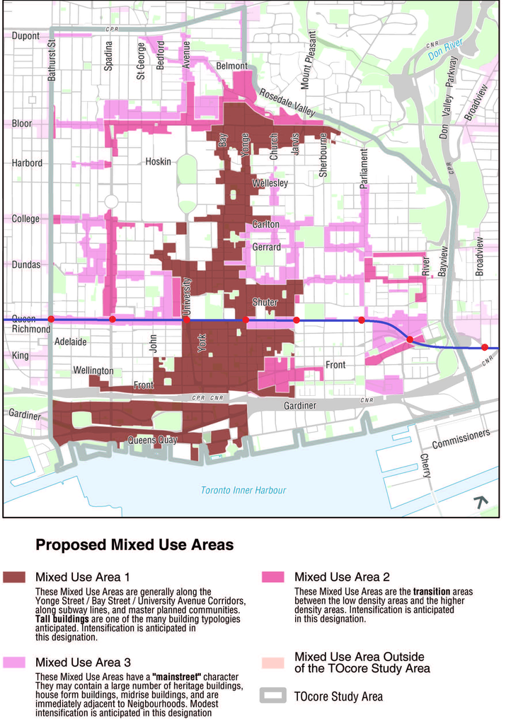
MixedUsePDF.jpg

You should become a city planner. :)
 
Last week on plan a relief line:
attach1.png


attach2.png


This week on plan a relief line:
attach3.png


attach4.png

It's perfect how "Impacts on Cultural/Heritage/Archeological Features" and "Eliminating Barriers within Neighbourhoods" are lowkey chilling on the left side of the slide. It went from being massively overplayed in the summer to not meriting a single word mention a few months later.

As usual with these "just walk a little longer" transit discussions, your estimate is deliberately way off from reality. And of course you have nothing to say about the subway to bus transfer, which would be inconvenient any way you look at it.

View attachment 101285

However if you are a resident who live at Carlaw & Queen, then sure 2 extra minutes is not a big deal. But if your condo is further up the street near Dundas, then that 2 minutes is an addition to your existing walk. In fact if you also consider that the north side subway entrance at Colgate Ave would be gone with the Pape alignment, then the extra walking time for many residents would look more like this:

View attachment 101290

I had a look in Google maps and our friendly mod ranting about single detached housing is out of line because it's mostly row housing on Pape. During the same Maps session, another joke became apparent. There is a WoodGreen seniors building, YWCA apartments, and other apartments on Pape. Why wasn't this mentioned in the SOCIAL EQUITY rating?? Keesmat and the planners are the real joke.

attach5.png


The maybe 300 people on Carlaw who might have to walk to Pape is nothing compared to the 10,000+ people who need to get to school at George Brown, court at St. Lawrence Market, or jobs at the King East office cluster. Those people will need to walk even more distance and waste more time and risk their lives crossing Richmond, Adelaide, King, and maybe Queen too if the exits are poorly placed. Kessmaat and co already says these are acceptable losses.

You should become a city planner. :)

We're not a good fit. I don't bow down to Tory or his pet dragons.
 

Attachments

  • attach1.png
    attach1.png
    44.3 KB · Views: 293
  • attach2.png
    attach2.png
    157.1 KB · Views: 296
  • attach3.png
    attach3.png
    163.8 KB · Views: 276
  • attach4.png
    attach4.png
    117.5 KB · Views: 289
  • attach5.png
    attach5.png
    44.3 KB · Views: 294
Last edited:
West of Spadina, pretty much everything on Queen and points north are classified as either "heritage" or "stable neighbourhood". Someone posted a picture of it from the Plan. Good thing the hacks at planning recommended Queen!

This is not the picture which I was talking about but it's more ammo against the incompetents at planning

Borrowing from the image you've sourced, it becomes even more abundantly clear how a station at Sherborune St makes absolutely no sense:


As depicted, Jarvis St lies at the eastern end of the skyscraper developments and would be the best suited location for a station to handle that density as it also neighbours three major institutions (St Michael's Hospital, Ryerson University and George Brown College).

That map also illustrates how Parliament St is a major secondary corridor and should be directly served by a station.

Sherbourne/Queen as shown on that map has zilch, nada, nothing worth serving with a direct subway stop. Please TPTB apply some common sense here and think of average walking times for the majority of transit users downtown. 2 stations are better than one and sometimes, as the Carlaw alignment today demonstrates, going the more expensive route benefits the most people in the long run.
 

Back
Top