Toronto Ontario Line 3 | ?m | ?s

This isn’t about a simple disagreement.
It is. Simply because you can't admit the mistakes in your plan, and instead resort to name calling to those who point out the flaws.

At the same time your only response to the questions I've got about the flaws I've identified is that they are "ninny questions'.

Well you told me! LOL! I think we're done here.
 
I’ll set the record straight. Not as part of my argument with nfitz, but in general and to other readers. There are no “mistakes” in my Don Line fantasy map. If something is technically impossible or 100% unrealistic - yes it can be considered a mistake or flaw. I’m by no means saying it’s “the right plan” or that it can never be altered; but rather that it’s mildly realistic and can theoretically work as an affordable rapid transit alternative to the long-established DRL route.

I'll gladly debate issues like station location, technology, alignment changes, etc. But I don’t care for comments that disregard and discredit this plan (or any plan for that matter) simply because it isn’t what they want it to be.
 
Last edited:
I'm heading to the pharmacy. How many should I pick up?

FBS-00340-3.jpg
 
Back on topic...

NcOs7xx.png


King-Pape alignment. End it at Roncesvalles, have it serve the Portlands.
Interchanges with GO RER (or Smarttrack, whatever) at Roncesvalles, Shaw, and Gerrard

Routing the line to the Portlands makes a convenient extraction point for TBMs, and would also act as a catalyst for development of the surrounding brownfield.
 
I'm a huge fan of any DRL alignment that reaches Sunnyside.

Sunnyside can become a transit hub with the DRL, GO RER, WWLRT and Queen streetcar all connecting there.
 
There's essentially no valley where Queen Street crosses the Don - the river is almost at street level. The depth of stations in that area is a complete non-issue.

Is this for certain? Yes, the Don Valley is fairly shallow at/around Queen. But it still presents a terrain and subsurface incongruity compared to elsewhere across the city. I’ve posted some of this info before, so it may be a bit of a rehash.
The river and its saturated deposits do go down some ways: First as tens of metres of porous till, followed by mixed clay (more than likely porous/saturated), and a very deep shale bedrock surface (~100ft). And it’s probable that the upper portion of this shale is well fractured, saturated, and considered as part of the aquifer. Contrary to what many think, the Don and Humber valleys weren’t entirely created during the last ice age. Rather, they were traced millions of years prior by the now nonexistent Laurentian River.

Cross-section which shows the Don south of Queen:
Don_cross-section.jpg


Even downtown’s water supply follows the significant dips in bedrock which underlie our valleys, as seen in this cross-section along the waterfront:
Don_cross-section_2.jpg


The lower Don Valley at Queen isn’t a broad channel or harbour where any surface subsidence caused by tunnelling can go unnoticed. It’s a narrow and vital corridor used for freight, rail, Bayview, DVP, gas, hydro...all either abutting or within metres of a confined waterway. If a significant breach were to undermine the surface, the entire Lower Don corridor could grind to a halt. Obviously some degree of clearance will be required if we decide to bore two enormous tunnels below.

Here are some points concerning the Yonge North subway extension’s planned crossing of the East Don, which I believe are relevant and worth mentioning. http://www.vivanext.com/assets/files/enviroAssess/subways/yonge/updates/East_Don_River_Crossing.pdf

Costs and depth
Subway station depth has a significant impact on user convenience, subway evacuation response time and station construction cost. Deeper subway stations increase passenger intermodal transfer time, reducing transit efficiency, and resulting in longer and more difficult evacuation in the event of emergencies. Station construction costs increase with greater depth at a rate that is of the order of one million dollars per additional one metre depth, over and above the cost of all other station facilities. For these key reasons it is important to keep subway stations as shallow as possible.​

Costs and gradients
The subway elevation at the East Don River crossing and the location and depth of stations on either side of the East Don River Valley are interdependent due to requirements to maintain standard-track gradients. A maximum gradient of 3.5% was used for running sections of track and a much lower maximum of 0.3% for station areas as per TTC standards for subways. These and other standards were applied to the tunnel alternative, which crosses well under the East Don River for environmental and structural reasons, and resulted in subway stations on either side of the East Don River valley that were in the order of 35m deep. This depth is almost twice the depth of the existing deepest TTC subway station (Bayview Avenue at 18.6 metres). The majority of the existing stations in the TTC system are less than 13 metres deep​

Safety requirements
Even if no station is built on either side of the valley (Centre or Royal Orchard), surface emergency exit buildings would be built to meet the Ontario Building Code for underground rapid transit facilities and TTC design standards, requiring a maximum distance from emergency exit to emergency exit or emergency exit to station of 762 metres, representing significant evacuation challenges in the case of emergencies.​

Environmental issues
The tunnel alternative would likely have a greater impact on underground water than the bridge alternative. While the bridge piers have the potential to impact ground water flow, the tunnel alternative would likely require ongoing dewatering as part of normal subway operations and maintenance. Further, the tunnel alternative would require stations at significantly greater depths on either side of the East Don River valley increasing the magnitude of the excavations and dewatering necessary for construction purposes.​

What’s concluded as the most optimal alternative in the case of the Yonge extension is a bridge over the East Don: shallower stations, reduced gradients, reduced groundwater pumping during and post-construction. Although both locations aren’t identical and provide their own challenges, it’s safe to reason that at least some of these findings can be loosely carried over to the similar situation concerning the DRL’s crossing of the Lower Don. And that tunnelling below the Lower Don will increase the DRL’s scope, costs, and technical challenges. Again, I’m not saying it’s impossible to tunnel.

On the topic of tunnelling through Toronto bedrock, this article is quite interesting: http://spacing.ca/toronto/2014/10/03/torontos-swelling-bedrock/ Apparently Toronto’s bedrock is unique in that it swells and can deform underground structures that haven’t factored in this intense pressure. As well, I thought this to be neat map because it gives cross-section transects of Yonge and B/D lines. http://www.geologyontario.mndm.gov.on.ca/mndmfiles/pub/data/imaging/P2204/RASTER/00256477.jpg
 

Attachments

  • Don_cross-section.jpg
    Don_cross-section.jpg
    282.7 KB · Views: 758
  • Don_cross-section_2.jpg
    Don_cross-section_2.jpg
    409.6 KB · Views: 754
I'm a huge fan of any DRL alignment that reaches Sunnyside.

Sunnyside can become a transit hub with the DRL, GO RER, WWLRT and Queen streetcar all connecting there.

Amen. The development out by the Humber and along the Queensway needs to be much better served and would be enough in passengers per hour to justify bringing the line that far west.

I would be happy with the DRL ending at Liberty and an LRT tunnel from there to Sunnyside. The vehicular congestion at the Roncy-Queen intersection is likely not solvable through traffic control, and a dedicated lane for LRT at that intersection would create an unacceptable obstacle for traffic.

Or....if the DRT were built as LRT (does it need 30K capacity?) it could be one route from Sheppard to Long Branch.

- Paul
 
Is this for certain? Yes, the Don Valley is fairly shallow at/around Queen. But it still presents a terrain and subsurface incongruity compared to elsewhere across the city. I’ve posted some of this info before, so it may be a bit of a rehash.
Nothing that other cities haven't dealt with before.

(does it need 30K capacity?)
Yes. In fact, Metrolinx predicted peak hour boardings of almost double that. If there's any new line in the city that justifies that much capacity, it's the DRL.
 
Back on topic...

King-Pape alignment. End it at Roncesvalles, have it serve the Portlands.
Interchanges with GO RER (or Smarttrack, whatever) at Roncesvalles, Shaw, and Gerrard

Routing the line to the Portlands makes a convenient extraction point for TBMs, and would also act as a catalyst for development of the surrounding brownfield.

I don't really see the point of a subway underneath King with the rail corridor so closeby. If SmartTrack is happening, the next logical place for a east-west downtown subway is Queen Street.

Amen. The development out by the Humber and along the Queensway needs to be much better served and would be enough in passengers per hour to justify bringing the line that far west.

I would be happy with the DRL ending at Liberty and an LRT tunnel from there to Sunnyside. The vehicular congestion at the Roncy-Queen intersection is likely not solvable through traffic control, and a dedicated lane for LRT at that intersection would create an unacceptable obstacle for traffic.

Or....if the DRT were built as LRT (does it need 30K capacity?) it could be one route from Sheppard to Long Branch.

- Paul

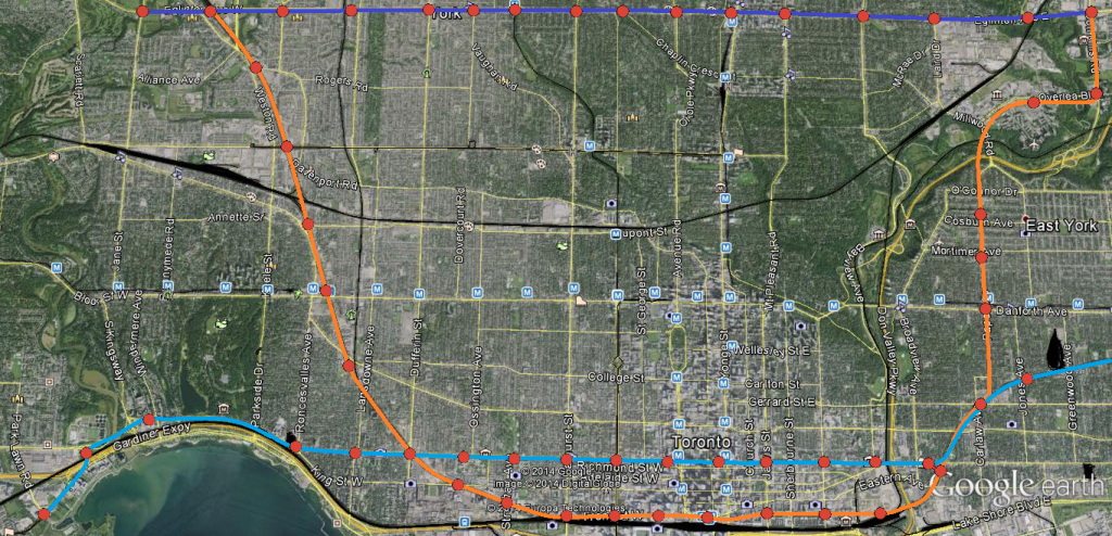
In a perfect world, we would be building something like this:


As I said before, if we're building SmartTrack (cyan) as complimentary to a true DRL (orange); have the second subway line travel across the central core west to the developments along the Humber Bay area. Think of all the nodes/trip generators within easy walking distance of Queen (Chinatown, Queen West, CAMH lands, Parkdale, SoHo, Eaton Centre, City Hall, Regent Park) that'd be so much harder to access if the alignment were King.

Meanwhile a DRL following the rail corridors, the Esplanade and Front St W would allow for easy walking distance access to: Unilever, West Don Lands, the Distillery District, St Lawrence, Union Station, CN Tower/Ripley's/Skydome, CityPlace, Liberty Village. A King alignment only has a more direct connection to the Financial District going for it, so in my opinion dual subway lines through the core are of more benefit than trying to force everyone onto King.
 
I don't really see the point of a subway underneath King with the rail corridor so closeby. If SmartTrack is happening, the next logical place for a east-west downtown subway is Queen Street.


In a perfect world, we would be building something like this:


As I said before, if we're building SmartTrack (cyan) as complimentary to a true DRL (orange); have the second subway line travel across the central core west to the developments along the Humber Bay area. Think of all the nodes/trip generators within easy walking distance of Queen (Chinatown, Queen West, CAMH lands, Parkdale, SoHo, Eaton Centre, City Hall, Regent Park) that'd be so much harder to access if the alignment were King.

Meanwhile a DRL following the rail corridors, the Esplanade and Front St W would allow for easy walking distance access to: Unilever, West Don Lands, the Distillery District, St Lawrence, Union Station, CN Tower/Ripley's/Skydome, CityPlace, Liberty Village. A King alignment only has a more direct connection to the Financial District going for it, so in my opinion dual subway lines through the core are of more benefit than trying to force everyone onto King.

Is it not better to have the DRL reach Humber Bay and SmartTrack go north along the rail corridor towards Pearson?
 
The DRL isn't going anywhere. It's not dead but has been put on the backburner until SmartTrack is up and running.

I think this is great because SmartTrack can still work as a DRL but at the same time serve dozens of new destinations and hundreds of thousands more people than a DRL will. The DRL will also take forever to build and Torontonians are tired of waiting, They need rapid transit and they need it ASAP and a DRL doesn't offer that.
 

Back
Top