Hamilton Hamilton Line B LRT | ?m | ?s | Metrolinx

Good for Hamilton for pursuing LRT.

But they really need to get the Airport out of the plans. The LRT will have to go through 6km of rural farmfields to get there, and the airport isn't even busy, serving a dozen flights a day or so. Such a line would be comically underused; a guaranteed white elephant.

That whole section of land will be turned into industrial use - the attractive of the land will jump once the LRT is complete, the city is currently finalizing a master plan for the area. Citi Bank now owns 50% of the Airport.
 
Good for Hamilton for pursuing LRT.

But they really need to get the Airport out of the plans. The LRT will have to go through 6km of rural farmfields to get there, and the airport isn't even busy, serving a dozen flights a day or so. Such a line would be comically underused; a guaranteed white elephant.

I had visions of Mid-America airport in Illinois when seeing the airport as part of the North-South LRT.
 
That whole section of land will be turned into industrial use - the attractive of the land will jump once the LRT is complete, the city is currently finalizing a master plan for the area. Citi Bank now owns 50% of the Airport.

It will take decades to develop all that land. Even when it has been developed industrial isn't a very high intensity land use, generating little transit ridership (industrial areas everywhere are normally served by low-frequency rush-hour-only bus routes). It's unlikely that LRT has any measurable effect on the locational decisions of a warehouse or light industry.

If you want to encourage industrial development, LRT isn't the right tool for the job. Improve road and heavy rail access.
 
There's the new 403 exit, Highway 6, to the Airport and it's all empty land along that land. The city would like to go for Phase II to extend the Red Hill Expressway right up to the Airport.

Then there's the possible GTA-Niagara highway that would go right in front of the Airport. But the province is soft on that approach so it's likely they'll spend the money on having LRT to the Airport instead of the new highway.

Also since Citi Bank now owns 50% of the Airport I wouldn't be surprised if the City requested them to fund the streetscaping from Rymal to the Airport.

The Airport has been pushing to have LRT connections for well over a decade now. The city sees this as a great opportunity to create new jobs as the last two decades hasn't been well for Hamilton's economy.
 
The Airport has been pushing to have LRT connections for well over a decade now. The city sees this as a great opportunity to create new jobs as the last two decades hasn't been well for Hamilton's economy.

Then they should study and explain how LRT through farm fields will help create new jobs. Is there any evidence that industries factor the location of LRT into their choice of building location? There are hundreds of pieces of unused and underutilized infrastructure all over the world, built to encourage development that either never occurred, or DID occur but had no need for the infrastructure that was provided.

A real need for new jobs in the Hamilton area should not excuse foolhardy decisions. The complaining of Hamilton and GTA residents about the waste of money of empty LRT cars running every 30mins or less over a track that will cost tens of millions will make the hullabaloo over the Sheppard "subway to nowhere" look like nothing... Hamilton doesn't need the embarrassment. End the LRT at Rymal and run a bus from there onwards. Preserve a right-of-way for the LRT so that everyone knows that when the demand justifies it, the LRT will be extended.
 
img_46626.jpg


Source: NYC Subway (world.nycsubway.org)
 
The HSR Transit Service is up on the Mountain, Upper James (that's where all the buses get stored), and it's pretty much half way between Rymal and the Airport, it's likely where they'll build the LRT storage building for the A-Line.
 
Good for Hamilton for pursuing LRT.

But they really need to get the Airport out of the plans. The LRT will have to go through 6km of rural farmfields to get there, and the airport isn't even busy, serving a dozen flights a day or so. Such a line would be comically underused; a guaranteed white elephant.

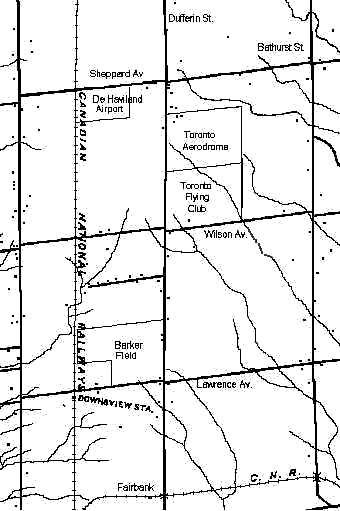
Compare that with this map of some other airports in the Toronto area, I guess you're right:

Dnsv1932.gif
 
It's only a matter of time before developement reaches the airport. Upper James has changed drastically in the last 10 years plus Upper James is getting pretty congested these days. If your going to take and LRT up to Rymal Rd why not go the extra couple km's to have an airport connection?
 
It's only a matter of time before developement reaches the airport. Upper James has changed drastically in the last 10 years plus Upper James is getting pretty congested these days. If your going to take and LRT up to Rymal Rd why not go the extra couple km's to have an airport connection?

It's not an extra couple kilometres, it's about 7km. Longer than the original Yonge subway line, longer than the Sheppard subway. From the waterfront at James St and Burlington St to the Airport via Claremont access is 17.3km. Taking the route from Rymal to the airport will almost double the length of the route! 43% of the route will run through rural lands! Hamilton will have to double in size for development to reach Airport Rd.

Tens or hundreds of millions of dollars to serve several dozen potential passengers a day.

If the Toronto Suburban Railway could run a radial streetcar from Lambton, in Toronto, to Guelph, a distance of 74 km, it should be easier to go 7 km. While it did close down due to the automobile and low frequency, I do see more than the several dozen you mention using the Hamilton-Airport route than the Toronto-Guelph route.
 
Considering the LRT wouldn't be built for another 5 years or so, by that time the gap between development and the airport would probably be only a couple km's. If Toronto was to build an LRT within 2km of Pearson, wouldn't you agree they should have extended it?
 
If the Toronto Suburban Railway could run a radial streetcar from Lambton, in Toronto, to Guelph, a distance of 74 km, it should be easier to go 7 km. While it did close down due to the automobile and low frequency, I do see more than the several dozen you mention using the Hamilton-Airport route than the Toronto-Guelph route.

So we should run a line through farmer's fields because another line that did that shut down due to lack of riders in 1931. This was decades before there was ubiquitous automobile ownership or a competing expressway.

Or the TTC should have built LRT to the Dufferin and Wilson area in 1932, an area with 30 or so homes (by my count on that map you posted) when the TTC couldn't justify a bus service there until 22 years later.

Verifiable ridership projections is how transit should be planned. I'm yet to see an EA that is based upon a sense of nostalgia.
 

Back
Top