You are using an out of date browser. It may not display this or other websites correctly.
You should upgrade or use an alternative browser.
You should upgrade or use an alternative browser.
Toronto CIBC SQUARE | 241.39m | 50s | Hines | WilkinsonEyre
DonValleyRainbow
Senior Member
Member Bio
- Joined
- Mar 5, 2014
- Messages
- 2,867
- Reaction score
- 1,927
- Location
- Kay Gardner Beltline Trail
Wow, all these awesome updates since Thursday!
*and you get a like. and you. and you and you and you*
*and you get a like. and you. and you and you and you*
Michael62
Active Member
Concerning the beams that have been coming out of the site. If you look to the right of the dozer you will notice a wall structure built of large beams that resemble railway ties but are much longer, some as long as the old wooden telephone poles. There is a second wall slightly exposed on the just behind and to the right of dozer about 3m north of the first beamed wall. There have been a series of these walls running from east to west throughout the whole site. My best guess is that these walls were built as soil containment walls to keep the dirt in the area when they were trying to refill the marsh in the past. Just dumping loose dirt in the water would, overtime, be useless as wave action, storms and ship movements would erode this material unless it was contained by a series of walls. The excavation is down to a very dense concrete like material that requires time and effort to break-up. It appears to be a shale or very dense slate and my assumption is that this is the original lake bed. These beamed walls running from east to west, rest on the lakebed are built up from there and then are filled with dirt to reclaim some land. Historical reference is added below:
https://books.google.ca/books?id=wt5pDAAAQBAJ&pg=PA197&lpg=PA197&dq=toronto+filling+in+swampy+marsh&source=bl&ots=WfLMB-hhgd&sig=dyHvrkissNILJ9GLYwV5SkZcvrg&hl=en&sa=X&ved=0ahUKEwjQmcPbjNDXAhUpYt8KHevBClsQ6AEIODAC#v=onepage&q=toronto filling in swampy marsh&f=false

https://books.google.ca/books?id=wt5pDAAAQBAJ&pg=PA197&lpg=PA197&dq=toronto+filling+in+swampy+marsh&source=bl&ots=WfLMB-hhgd&sig=dyHvrkissNILJ9GLYwV5SkZcvrg&hl=en&sa=X&ved=0ahUKEwjQmcPbjNDXAhUpYt8KHevBClsQ6AEIODAC#v=onepage&q=toronto filling in swampy marsh&f=false
Attachments

maestro
Senior Member
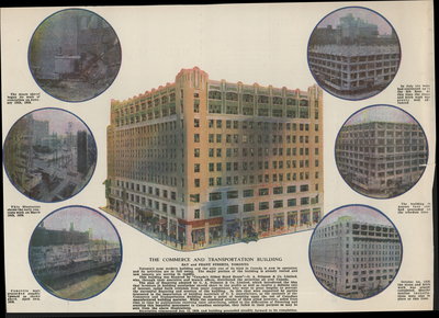
Very cool set. It include possibly the best image I've ever seen of the large Commerce and Transportation building that was destroyed to make way for the Canada Trust Tower.
AHK
Senior Member
Very cool set. It include possibly the best image I've ever seen of the large Commerce and Transportation building that was destroyed to make way for the Canada Trust Tower.
The Bay-Front Tavern, the Parking Garage, the Texaco gas service bar, ......
I fear I am showing my age with this comment.......
DonValleyRainbow
Senior Member
Member Bio
- Joined
- Mar 5, 2014
- Messages
- 2,867
- Reaction score
- 1,927
- Location
- Kay Gardner Beltline Trail
The excavation is down to a very dense concrete like material that requires time and effort to break-up. It appears to be a shale or very dense slate and my assumption is that this is the original lake bed.
Wow. Down to the Georgian Bay Shale you think? We got any resident geologists on UT?
Attachments
innsertnamehere
Superstar
Yes, likely the shale. It's fairly routine for the last level or so of parking garages to go through it, especially deeper garages. I guess this one is unusual as they are not currently that deep down.
innsertnamehere
Superstar
Also, the wooden posts are likely from the old dock wall.
ProjectEnd
Superstar
Very cool set. It include possibly the best image I've ever seen of the large Commerce and Transportation building that was destroyed to make way for the Canada Trust Tower.
It's funny how while we remember a good number of our lost buildings through photos, social history, etc., regardless of size, when some of them are gone, they're gone.
eltodesukane
New Member
Some changes over the years..


Last edited:
Michael62
Active Member
Westside: They've cleared out all the scaffolding under the concrete deck and have begun to dig down in this area. It's getting difficult to distinguish depth from one area to the next as the slate ground blends into one mass. In the northwest corner and under most of the concrete deck the excavation has dropped about 1m. They poured more concrete deck (hidden by black plastic) towards the Bay East Team Way and continue to create form work preparing for another pour in the future.

Eastside: an new ramp down into the excavation has appeared and the old ramp is in the process of being removed. More excavation has happened along the north wall and in the area behind 18 Yonge St. It's at a working level that the tieback machines can complete the third row. About half of the 4th row of anchors have been complete

Eastside: an new ramp down into the excavation has appeared and the old ramp is in the process of being removed. More excavation has happened along the north wall and in the area behind 18 Yonge St. It's at a working level that the tieback machines can complete the third row. About half of the 4th row of anchors have been complete
Attachments


dahusbandofbath
Active Member
Just to be clear, this map does not depict the property involved in the construction of this tower, which is located on the east side of Bay St. The Union Station indicated on this map was located west of the current station.Or, more likely, there were rail lines ON the land and when the berm was built they were not usable so they removed the rails but left the ties. Only way to really know would be to see if they are lying in a pile or are arranged like a railway. From the 1913 Goads it looks as though there were many rail sidings in that area.
View attachment 127550
DSC
Superstar
Member Bio
- Joined
- Jan 13, 2008
- Messages
- 19,985
- Reaction score
- 29,217
- Location
- St Lawrence Market Area
True, the map I posted earlier is a bit west - the Union Station noted is NOT the current one but the earlier station that was west of the current one. Here is the 1913 map a bit east of the other shot - CIBC Square is really over Bayside Park. No rails exactly there but lots in the area and, as noted elsewhere, the rail ties may actually be 'crib-work' installed while lake-filling.Just to be clear, this map does not depict the property involved in the construction of this tower, which is located on the east side of Bay St. The Union Station indicated on this map was located west of the current station.
Attachments

Blitz901
New Member
I think the dark ground is likely glacial till. Which is basically a mix of rock (possibly shale), sand, etc. It is usually very compact and hard (due to the mix of large rocks, fine dirt and weight of previous glaciers that were on top) for earth but diggable. I doubt that you would encounter shale at this shallow depth as there is a lot of fill on top of what use to be the 'natural' elevation of the land. Further to excavate intact shale you would need a ripper on the back of the dover at a minimum, which i do not see. Most building excavations in TO are in glacial till, even the ones further north that had no fill material placed on them 100 years ago.Wow. Down to the Georgian Bay Shale you think? We got any resident geologists on UT?
View attachment 127907
AlvinofDiaspar
Moderator
I think the dark ground is likely glacial till. Which is basically a mix of rock (possibly shale), sand, etc. It is usually very compact and hard (due to the mix of large rocks, fine dirt and weight of previous glaciers that were on top) for earth but diggable. I doubt that you would encounter shale at this shallow depth as there is a lot of fill on top of what use to be the 'natural' elevation of the land. Further to excavate intact shale you would need a ripper on the back of the dover at a minimum, which i do not see. Most building excavations in TO are in glacial till, even the ones further north that had no fill material placed on them 100 years ago.
You might hit shale at this depth - the new Harbourfront underground parking garage was going to hit shale at level 4 or so - and it is quite a bit further south.
AoD