News   Nov 27, 2024
 285     0 
News   Nov 26, 2024
 1.1K     1 
News   Nov 26, 2024
 738     0 

Roads: Ontario/GTA Highways Discussion

Honestly id be happy with a provincial highway style road along the gta west corridor ( a la hwy 9 or 115/35) rather than a full 400 series highway. East west travel across the central/north part of york region is a hige pain.

An alternative 400 series rouring id suggest is from just north of barrie (around the 400/11 split, and running roughly south west through orangeville and the kitchener/waterloo/guelph triangle. I can see this routing being beneficial to trucking companies bringing goods to/from central/northern ontario and south western Ontario while bypassing the gta
There is a major hydro corridor parallel to highway 400.
Considering that both 403 and 407 follow hydro for quite a while, I would say this might be a good bet for an alignment.
This would basically be a hwy 427 extension.
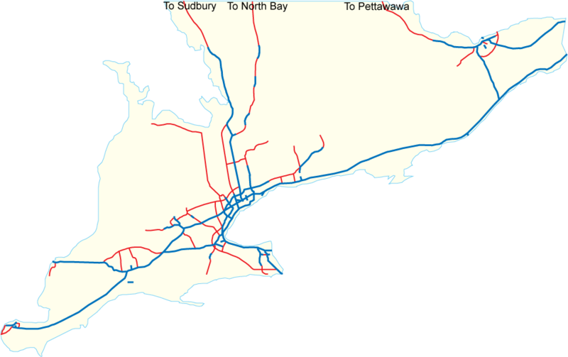
Adding in a few other proposals (purple) such as; Bradford Bypass, GTA West highway (413), hwy 404 extension, hwy 7 new between Guelph and KW, Morriston By-pass - we can see what missing is (blue) a freeway from Brampton to Guelph, and a connection of hwy 11 to hwy 400 (@ Gravenhurst).
The final thing missing (not shown at all) is an extension of hwy 413 to connect with hwy 404, 48 and maybe hwy 12.

Putting some numbers to it. What's a freeway cost nowadays - about $10M per lane km?

Highway 427 extension = 75 km = $3.0B.
Highway 413 = 50 km = $4.5B.
Highway 7 New = 20 km = $0.75B
Bradford Bypass = 25km = $1.0B
hwy 404 ext. = 35 km = $1.5B
Hwy 412 ext. = 8 km = $0.4B
Morriston bypass = 4 km = $0.25B.

Brampton-Guelph hwy = 40km = $2.0B
Gravenhurst Connector = 40 km = $2.0B

Total = 3000 km = $16.0B


1594500762423.png
 
Last edited:
There is a major hydro corridor parallel to highway 400.
Considering that both 403 and 407 follow hydro for quite a while, I would say this might be a good bet for an alignment.
This would basically be a hwy 427 extension.
Adding in a few other proposals (purple) such as; Bradford Bypass, GTA West highway (413), hwy 404 extension, hwy 7 new between Guelph and KW, Morriston By-pass - we can see what missing is (blue) a freeway from Brampton to Guelph, and a connection of hwy 11 to hwy 400 (@ Gravenhurst).
The final thing missing (not shown at all) is an extension of hwy 413 to connect with hwy 404, 48 and maybe hwy 12.

Putting some numbers to it. What's a freeway cost nowadays - about $10M per lane km?

Highway 427 extension = 75 km = $3.0B.
Highway 413 = 50 km = $4.5B.
Highway 7 New = 20 km = $0.75B
Bradford Bypass = 25km = $1.0B
hwy 404 ext. = 35 km = $1.5B
Hwy 412 ext. = 8 km = $0.4B
Morriston bypass = 4 km = $0.25B.

Brampton-Guelph hwy = 40km = $2.0B
Gravenhurst Connector = 40 km = $2.0B

Total = 3000 km = $16.0B


View attachment 256802

Sigh, all very environmentally destructive.

Apparently no value on the thousands of hectares of class 1 farm land that would destroy, and thousands more of forests and wetlands.

It would vastly inflate the cost of cottage country real estate, make dozens of species locally extinct (extirpated) would drive climate change, even in a full-electric car world with thousands of lane-km of new pavement too.

For 16B we can build high-speed rail to Barrie; high-speed rail to K-W, and have some leftover to beef up GO Transit as well.

Or if we dump the HSR in favour of GO would could built out full-RER on pretty much every route, save Richmond Hill; but likely add a midtown connector on top, as well as the missing link.

Yikes!

What a way to waste 16B.
 
Okay if you make high speed rail to Barrie what are suppose to do after there.

Walk the 50km to the cottage :p

Lol not saying we need to build ton of highways.


Maybe expand the 400 through Barrie and extend the 404 towards 12/48.
 
Okay if you make high speed rail to Barrie what are suppose to do after there.

Walk the 50km to the cottage :p

No.

The point of HSR to Barrie is not cottage-bound traffic.

Its removing a large portion of the Barrie-Toronto and reverse traffic; which then makes room for cottage-country drivers.

Rail is never going to be a large part of cottage-country/camping/resort traffic.

But highway 11, past Orillia isn't super congested most of the time.

Its the section from just north of the 400/11 split, south through Barrie that's really congested.

So the traffic using that section in the principle target.

You can alleviate small pockets of the leisure market (for instance a dedicated bus serving Deerhurst or the like could make a rail connection.

A train on to Wasaga/Blue Mountain/Collingwood (done properly) would do a good trade, but that portion could also be frequent inter-city bus meets train in Barrie.

Addressing some of the local traffic of residents from Orillia to the Muskokas w/better local transit could also make a difference at the margins. But it won't shave more than 3% of demand I wouldn't think.

Beyond that, we need to outlaw lot splitting and building ever more mansion like cottages that simply serve to decimate the very nature people came to see.
 
Last edited:
Land assembly/protection for the 407 corridor dates back to the 1960s. I doubt that has happened for the Hydro One corridor north from Kleinburg to the Moose River as it is largely easements. I would guess the per-kilometre highway construction costs do not include land acquisition, including connecting corridors. Since the easement corridor is wide only enough to accommodate and protect the circuits, it would be interesting to know if there are major highways directly under high-capacity power lines anywhere in the world. Beyond liability, how would maintenance take place. Power transmission corridors and highways traverse factors such as grades and wetlands quite differently.
 
Land assembly/protection for the 407 corridor dates back to the 1960s. I doubt that has happened for the Hydro One corridor north from Kleinburg to the Moose River as it is largely easements. I would guess the per-kilometre highway construction costs do not include land acquisition, including connecting corridors. Since the easement corridor is wide only enough to accommodate and protect the circuits, it would be interesting to know if there are major highways directly under high-capacity power lines anywhere in the world. Beyond liability, how would maintenance take place. Power transmission corridors and highways traverse factors such as grades and wetlands quite differently.

Secondary Land Uses
on Hydro One Right-of-Ways

From link.

Hydro One's transmission corridors, or Right-of-Ways (ROWs), are essential in delivering safe, reliable and affordable electricity throughout the province. They allow Hydro One 24/7 access to the towers and lines for routine maintenance and in emergency situations.

Many ROWs also have sufficient space to provide for expansion of Hydro One's facilities to accommodate future growth. The ownership of ROWs is diverse and includes government, Hydro One, private property owners, railway companies, and Indigenous communities.

The Ontario government has established a Provincial Secondary Land Use Program (PSLUP) that allows for the use of ROWs, while taking into account the primacy of use of these lands is for electricity transmission and distribution.

Hydro One strives to work with proponents to review secondary land use proposals on the ROWs so that they are compatible with the safety and maintenance requirements of our high-voltage equipment.

VERTICAL CLEARANCE

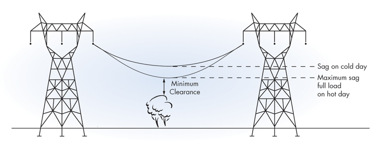
Transmission conductors (wires) are dynamic in nature. They can sag lower to the ground depending on parameters such as ambient temperature and operating conditions. Minimum vertical clearances must be maintained from the maximum design sag levels of the conductors (worst-case scenario). Hydro One will review these clearances as they are case-specific and not immediately apparent by observation alone.

Vegetation_Management_infographic.jpg


ACCESS TO STRUCTURES

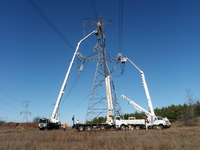
An unhindered, minimum 6-metre wide access path to facilities on the corridor must be provided for maintenance vehicles. A 15-metre clear working radius around transmission structures is required in order to maintain access for vehicles carrying out routine maintenance. A 3-metre radius around each tower footing must be left unpaved for access to the footing.

15-Meter-Requirement_low-res.jpg


GRADING, DRAINAGE AND STORMWATER MANAGEMENT
  • Grading changes must not impact vertical clearance requirements or result in standing water anywhere along the corridor.
  • No fill material may be placed on the ROW without written approval from Hydro One.
  • Catch basins that are not positioned within a paved roadway are not permitted.
  • Stormwater management (SWM) ponds placed under 115 and 230 kV transmission lines cannot exceed two-thirds of the corridor width.
  • SWM ponds under 500 kV transmission lines cannot exceed one-third of the corridor width.
  • SWM ponds must be designed to withstand the effects of 100-year storm conditions.


ROADS AND PARKING

Roads crossing the ROW should be perpendicular to the hydro corridor. Curb cuts or access gates should be provided for Hydro One maintenance vehicles. Parking facilities on 115 kV and 230 kV ROWs should be restricted to passenger vehicles only. Large truck and trailer parking is not permitted. Parking facilities are not permitted under 500 kV ROWs. Transmission towers near roads and parking areas must be protected by standard highway barriers.

PIPELINES AND UNDERGROUND FACILITIES

All underground facilities must be designed to withstand the loading conditions created by heavy maintenance vehicles that may be used by Hydro One. The ROW must be restored to pre-construction condition once the project is completed. Excavation using heavy machinery is prohibited within 10 metres of tower footings to protect foundations. Within 10 metres, excavation must be carried out by hand or by use of a VAC system. Pipelines on ROWs must adhere to the provisions of CSA Standard C22.3 No. 6.

LANDSCAPE PLANTINGS

Plantings which grow to a maturity height over 4 metres are not permitted on the ROW. These low-growing shrubs are permitted to be planted on ROWs, including: Gray Dogwood, Red Oiser Dogwood, Alternate Leaf Dogwood, Cornus racemosa, Cornus sericea, Cornus alternifolia, Elderberry, Sambucus Canadensis, Forsythia, Forsythia ovate, Honeysuckle, High Bush Cranberry, Lonicera spp., Viburnum trilobum, Mugo Pine and Pinus mugo mugo.


These shrubs should be planted in such a way as to not impede access to the transmission towers. An area of 15 metres around transmission towers should be kept clear of shrubs to permit Hydro One access to towers.

All plantings must be consistent with the Hydro One-approved species list and the overall plan is subject to Hydro One’s approval. Visit Vegetation Management for more details.


OTHER REQUIREMENTS
  • Buildings and permanent structures are not permitted on ROWs.
  • Flammable or hazardous materials may not be stored on ROWs.
  • Consideration should be given to minimizing the use of conductive (metallic) material where alternatives exist (e.g. fences).
  • The proponent is responsible for all costs of modifying, relocating, or monitoring Hydro One assets as a result of its proposal...
 
There is a major hydro corridor parallel to highway 400.
Considering that both 403 and 407 follow hydro for quite a while, I would say this might be a good bet for an alignment.
This would basically be a hwy 427 extension.
Adding in a few other proposals (purple) such as; Bradford Bypass, GTA West highway (413), hwy 404 extension, hwy 7 new between Guelph and KW, Morriston By-pass - we can see what missing is (blue) a freeway from Brampton to Guelph, and a connection of hwy 11 to hwy 400 (@ Gravenhurst).
The final thing missing (not shown at all) is an extension of hwy 413 to connect with hwy 404, 48 and maybe hwy 12.

Putting some numbers to it. What's a freeway cost nowadays - about $10M per lane km?

Highway 427 extension = 75 km = $3.0B.
Highway 413 = 50 km = $4.5B.
Highway 7 New = 20 km = $0.75B
Bradford Bypass = 25km = $1.0B
hwy 404 ext. = 35 km = $1.5B
Hwy 412 ext. = 8 km = $0.4B
Morriston bypass = 4 km = $0.25B.

Brampton-Guelph hwy = 40km = $2.0B
Gravenhurst Connector = 40 km = $2.0B

Total = 3000 km = $16.0B


View attachment 256802
It's cheaper and more useful to extend 404 around the lake than to build a low usage freeway through the Canadian Shield.
 
As far as rural highway projects go, here's my priority list:

1) Complete widening of Hwy 400 to Barrie.

2) Extension of Hwy 417 to at least Renfrew (though ideally Petawawa).

3) 400-series connection between K-W-C-G and Hamilton (via either Hwy 6, 8, or 24 corridors).

4) Extension of Hwy 404 to Hwy 48, widening of Hwys 48, 12, and 169 to act as a more attractive route around the east side of Lake Simcoe (I don't think full 400-series is necessary, but more than a two-lane road is needed).

5) 400-series extension of Hwy 7 from Carleton Place to Perth.
 
169 is very low traffic, it doesn't need a 4 laning.

400 widening, 404 to Sutton/48, and 4 laning of 48/12 to Highway 169 should be fine. A bypass of Brechin is also badly needed. I believe they are building a roundabout at 169/12 this summer, though I haven't drive through there this year to see.

I think 6 will be fine for the connection from Hamilton to K/W / Guelph with the Highway 5 interchange and Morriston Bypass. The most being necessary would be a RIRO.
 
My thoughts on road transportation in north GTA / Simcoe County:

1. Bradford Bypass is absolutely necessary. Maybe not right now, but in the very near future. The 401 is clogged, the 407 is too expensive. It makes sense that this link be built soon. Maybe it be numbered Highway 488? That makes the most sense to me.

2. I think Hwy 400 needs to be widened within Barrie sooner than south of it. The 400/11 bottleneck needs to be resolved. IMO the 400 should be widened (I know there are studies on this) from 6 to 8 lanes from Mapleview to the split. As traffic volumes dip slightly south of Mapleview, I think 6 lanes is still sutible. South of Highway 9, I think it needs to be widened to 8 lanes.

3. I do think that Highway 404 needs to be extended to at least Hwy 48 at Sutton, as traffic currently must take Ravenshoe from 404 to 48. A provincial highway is needed to fill the gap. Regarding 404 beyond Sutton, I believe this is more long term.

4. Highway 12/169 corridor from 48 to Washago/11: I don’t think this needs to be an extension of Hwy 404 as some in this forum have theorized, but some improvements in the Beaverton area, as well as a bypass of Brechin and a rebuild of the 12/169 junction (this is being studied) are warranted. 169 south of 11 should have never been downloaded from the provincial highway system.

5. A two lane (one in each dir.) Highway 26 bypass should be built around Stayner.

The last two thoughts are completely theoretical...

6. Regarding the Highway 26 corridor, I believed that 26 should be rerouted along Simcoe Road 53/Ferndale Dr as it is a faster route from 400/Toronto than Bayfield is.

7. Highway 90 should be reinstated as a provincial highway from the 400 to County Road 10 NORTH, and from that intersection, County Road 10 should be assumed by the province up to Wasaga Beach’s city limit, as an extension of Highway 90, and an alternate (and fairly direct) route from the GTA to Wasaga.
 
Last edited:
Yeah, there's no need for the 404 to go any farther, but Highway 48 is often too busy for a two-lane highway, with the 12/48 section around Beaverton especially bad. That needs to be addressed. But not as a 400-series highway.
I would like to see more limited access 4 lane expressways. Most of the TCH is build like that in the west with 100/110 limit. They're cheap 4 lane divided without any overpasses and interchanges which is usually the cost driver in freeways. Alberta seems to have almost 2000 km of divided 4 lane highways with mostly 100/110 limit for a province with a fraction of the population compare to us.

Many highways could use an upgrade like highway 6, 7, 10, 26 and 28. Here it seems like the plan is to build tiny freeway bypasses around towns and do nothing in the rural areas. In the prairies, the upgrade the rural highways to divided highway and slowly build bypasses for towns.

So in short, you want more RIRO expressways.
 

Back
Top