News   Nov 29, 2024
 465     0 
News   Nov 29, 2024
 239     0 
News   Nov 29, 2024
 559     1 

Road Safety & Vision Zero Plan

I asked the VisionZerro a couple of questions, their reply may interest others.

1. Pedestrian Head Start. Currently the standard practice is to add pedestrian head start phases to all feasible intersections across the City (some operations do not permit a head start signal, such as advance protected left turns) and it is being done during scheduled corridor signal timing reviews. Corridors in the City are regularly reviewed for timing and during this time these head start phases are being introduced. As changes to one signal can impact the entire sequence of signals in the vicinity it is best to make these changes when it can be applied across a larger geographic area.

2. Pedestrian actuated signals. For your second point the pedestrian actuated signals are typically at locations were a lower order road meets a higher order road, where the lower order road does not have sustained volume to warrant non-actuated operation. This assessment is done by our traffic signals group to determine the operation of each signal. If you have precise locations in mind that you think could benefit from a signal operation modification I would recommend emailing 311@toronto.ca with the location information or filling out an online service request here: https://www.toronto.ca/home/311-tor...s-sidewalks-and-traffic-safety/traffic-safety. Requesting an assessment through these channels will provide you with a reference number, which will make future follow up easier to track.


Their answer in #1 makes perfect sense, I just wish they would 'get on with it". I am not as satisfied with their policy in #2 as I think they base the 'sustained volume' on traffic and not on traffic and pedestrians. As a pedestrian, I find it confusing to be walking along a street where at some lights I need do nothing except wait for a pedestrian signal to flash while at others I need to press the button.

UPDATE: The VisionZero folk just told me that "I can confirm that the turning movement counts that are collected at intersections by our operations team do include motor vehicles as well as people walking and biking."
We just need a better system to inform pedestrian of different set ups.
On one extreme, this is what you might see in Japan:
Big sign next to the pedestrian signals "Push button set up (to cross)", and the wordy sign to the bottom which basically says (pedestrians) to obey your signal, since pedestrian and vehicle go phases may not be concurrent..
%E5%BE%85%E6%99%82%E9%96%93%E8%A1%A8%E7%A4%BA%E8%A3%85%E7%BD%AE%E3%82%92%E4%BD%B5%E8%A8%AD%E3%81%97%E3%81%9F%E6%AD%A9%E8%A1%8C%E8%80%85%E7%94%A8%E4%BF%A1%E5%8F%B7%E6%A9%9F.jpg
 
Not to single you out at all, but if a few more people on UT stopped complaining to the rest of us on UT about problems that needed to be fixed (we may be lovely people but most of us are quite powerless) and complained to people who have the power (and MAY have the will) to fix things (like 311), then more things would be fixed.
You could do both.
 
Not to single you out at all, but if a few more people on UT stopped complaining to the rest of us on UT about problems that needed to be fixed (we may be lovely people but most of us are quite powerless) and complained to people who have the power (and MAY have the will) to fix things (like 311), then more things would be fixed.

I used to actually do this stuff, but the last three years, between pandemic and kid being born, have been lost years for me. But I agree with you in principle. I do sit on the board of an organization that engages very vigorously with the City on certain issues, so I feel like that's my contribution right now.
 
^I’m actually fearful of automated pedestrian-detecting overrides for traffic lights, because (unlike autos, which seem to always be in a hurry) people on foot do loiter at intersections. Could be lots of spurious ‘hits’ on the detectors. Maybe there would have to be marked “stand here to trigger the lights” spots.

- Paul
 

Study: Megacar Drivers Up to 4x More Likely to Hit Walkers While Turning​

From link.

SUVs and pick-up truck drivers are three to four times more likely to hit a pedestrian when they make a turn than the drivers of smaller cars, a new study finds — and researchers think it’s because federal regulators aren’t scrutinizing the common design features that make it impossible for megacar drivers to see walkers passing right in front of them.

In a new study of federal crash data by the Insurance Institute of Highway Safety, researchers found that crashes in which a driver kills a walker are three times more likely to involve a left turn if that motorist was piloting an SUV at the time of impact, compared to fatal walking crashes involving the drivers of smaller cars.

Fatal crashes involving pick-up truck drivers, meanwhile, are four times more likely to involve a driver making a left — and when it comes to right-turn crashes, they’re still 89 percent more likely. Right-turning SUV drivers are 63 percent more likely to strike a person than the drivers of smaller vehicles.

And yes: all those numbers were adjusted for a broad range of systemic factors, including the age and gender of the motorists and walkers involved, whether the crash occurred in an urban or rural area, and key design features of the environment in which the crash happened, like whether the roads were well-lit. That means that the physical design of megacars themselves may be increasing the likelihood of their drivers’ hitting walkers — and when that happens, those cars are generally about two to three times more likely to kill, as earlier researcher has shown.
GHSA-crash-chart.jpg

Those dramatic numbers add to the mountain of evidence that America’s fast-growing fleet of ever-larger megacars are not just more dangerous to pedestrians when they’re going straight at high speeds, but in a variety of common roadway situations — and that the many design features that makethem so dangerous are in urgent need of regulation.

In particular, the researchers behind the study cited the design of a vehicle’s A-pillars — the vertical struts on either side of the windshield that connect the roof to the body of the car — which create a pair of potentially deadly blind spots for drivers. The larger the megacar, the wider and more visually obstructive its A-pillar, a feature which automakers say is necessary to prevent rollover crashes, though experts argue they could achieve the same occupant safety goals by making A-pillars out of stronger materials, while still keeping them skinny.

“This study points to another way to understand how the increasing popularity of SUVs could change the pedestrian crash picture,” said Dr. Wen Hu, senior transportation research engineer for the Institute. “We really need to systematically study the impact of A-pillar design on pedestrian visibility.”
A-pillar-comparison.png

Of course, A-pillars aren’t the only reason why megacars are so much more dangerous to walkers. A megacar’s height, boxy front-end design, and even the angle of the windshield can also increase its blind spots, but neither federal motor vehicle safety standards nor federal consumer safety ratings require automakers to assess how these design elements impact pedestrian safety.

For instance, the massive blind zones of the 2021 Ford F-150, one of the most popular new cars sold in the U.S today, can fit a staggering 578 preschoolers if they crowd close together, according to a calculator sponsored by USDOT.
F150-blind-zone.png

Hu is careful to point out that vehicle design isn’t the only factor that determines whether a given driver will strike or even kill a walker, and that vehicle speed, in particular, plays an outsized role in both. Turning crashes at intersections, of course, tend to occur at lower speeds, but they also happen more frequently than other types of collisions, particularly in urban areas with dense, connected grids — so much so that some experts think left turns should be banned entirely in areas where lots of people walk, and that right turns shouldn’t be allowed at red lights, either.

If those policies are implemented in concert with a broader Safe Systems approach, pedestrian lives could be saved — but vehicle design shouldn’t be left out out of the strategy.

“Improving vehicle design, along with addressing road infrastructure and vehicle speeds, can play an important part in reducing pedestrian crashes and fatalities,” Hu said. “Our findings suggest that looking at the problem through the lens of vehicle type could also be productive.”
 
Two minds with one thought, I was there this afternoon and have already reported it to 311 as instructed. You may want to do so too.
Here is the response. Patience!

Your request for service has been generated and the City of Toronto will handle your request with the details and reference number provided below.

  • Your Reference Number: 00710398
  • Service Request Type: Pedestrian Issues / Timing / Delays
  • Expected Service Delivery Date/Time: 2022-11-06, 6:00 p.m.
  • Estimated Resolution Timeframe: The Service Request will be resolved within 9 months.
  • Service Address: Lower Sherbourne St & Queens Quay E

Your reference number is required in order to check the status, make changes or cancel the request.
They could give birth within that timeframe.
 

Our most dangerous streets: Huge new collision database points to Toronto’s postwar suburbs

From link.

_1_main_markham_and_ellesmere.jpg

Toronto’s most dangerous roads all look the same: they’re big, they’re broad, and they’re not downtown.

A Star analysis of a huge new database of Toronto traffic collisions is shining a bright spotlight on a distinctly suburban problem. The new data set, much larger and more complete than any previously available records, offers a comprehensive account of nearly 500,000 collisions reported to Toronto police between 2014 and 2021, most mapped to the nearest intersection.

The takeaway is stark: nearly all of Toronto’s worst locations for reported fatal or injury-causing traffic collisions are suburban arterial intersections. The worst 100 spots, excluding municipal highways, are nearly exclusively found on arterial roads in North York, Etobicoke and especially Scarborough. These are long, wide avenues like Finch (20 locations in the worst 100), Sheppard (14), Steeles (12), Eglinton (11), Lawrence (10) and Ellesmere Road (10).

When mapped, those 100 spots fall almost entirely within the broad arc of the city’s suburban neighbourhoods built after the Second World War, outside the limits of the old cities of Toronto, York and East York. Just two spots in the worst 100 — Lake Shore Boulevard East at Carlaw Avenue, tied for 89th on the list, and Davenport Road at Bathurst Street, 94th — are in old Toronto.

In the eight years of police data, those 100 locations alone account for nearly 9,000 reported injury collisions, with 43 deaths.
1648828334422.png

Standing on the northwest corner of Markham and Ellesmere roads, watching the people of Scarborough navigate afternoon rush hour at one of the city’s worst hot spots, with 148 collisions causing injury, Keenan Mosdell says the problem is obvious.

The decades-old design of this major intersection, like many others in suburban Toronto, puts road users at risk, he says.

The big, wide arterial intersection lets drivers make fast, “dangerous” turns; cyclists throw themselves into traffic lanes to cross; a loud motorcycle driver guns it to beat a red light; and scores of pedestrians rush to barely make it across to catch their bus, the 102 northbound — all typical sights in Toronto’s post-Second World War suburbs, where collisions and injuries are commonplace.

“How can anyone feel safe here?” asks Mosdell, an avid cyclist and project co-ordinator for The Centre for Active Transportation.

What’s causing the collisions on Toronto’s suburban arterial roads?

Asked about the new police data, traffic services Supt. Scott Baptist pointed especially to speed. While downtown may have busy roads with higher concentrations of pedestrians and cyclists, a combination of lower speed limits, speed bumps and one-way streets makes it more difficult for drivers to speed. In the suburbs, the roads are wider and feel more open, often have higher speed limits and are usually less congested.

“Higher speeds often mean that collisions result in more damage to cars and humans,” he added, noting that speed is one of four main causes of traffic collisions, along with aggression, distraction and impairment.

The reason the suburbs are this way is by design, said urban designer and city building expert Ken Greenberg.

After the Second World War, the big ideas that shaped city building all over the world were based on the premise that the automobile would be the primary mode of transportation, he said. From home to work, to school, to shopping, to recreational facilities and to public parks, cities grew on the assumption their residents would drive almost exclusively.

“We were really meant to be going from one parking lot to another,” Greenberg said.

From the inner suburbs of Toronto to the rest of the Greater Toronto and Hamilton Area, city planners built big arterial roads of four to six lanes, often with added turning lanes, and intersections kilometres apart. Subdivisions and the streets serving them were largely designed for lower density than has actually developed, and even highrise residential buildings came with enough underground or above-ground parking spaces for everyone. No one was expected to walk, he said.
“It was a design for a different way of life that, ultimately, I just think was a failure in a bunch of ways,” Greenberg said.

The fix is to redesign these arterial roads, he said, noting that these busy suburban intersections may now be home to more people than spots in the older city, leading to more need to for infrastructure that keeps pedestrians and cyclists safe. The good news, Greenberg said, is that there’s enough space to undertake those redesign changes in the suburbs, unlike downtown, where it may be difficult to squeeze in something as simple as a new bike lane.

In the suburbs, you can take away lanes of traffic for dedicated bus routes, rapid transit or light rail. You can change the design of the intersections and the timing of the traffic signals. Examples of such redesigns are the Yonge Street North project in Willowdale, the Eglinton Connects project and, in Mississauga and Brampton, the Hurontario LRT.

Still, the scale of what needs to change requires real political will, Greenberg said, noting he’s seen this take place in Scandinavian cities like Helsinki, which also saw rapid suburbanization after the Second World War.

“Until we do that, people are going to be in jeopardy. They’re going to be in unsafe conditions. It’s all very well to say the drivers should slow down and pay more attention, but the designs don’t lend themselves to that.”

Added Mosdell: “These roads are doing what they were intended to do, which is to move cars fast … But we need to adjust and change, because Scarborough and other areas are now home to a lot of people with low income who can’t afford to drive. They need to be safe on the road, too.”

Through its Vision Zero plan, the city says it continues to make the elimination of traffic fatalities and injuries a priority, especially on high-speed suburban arterials, said spokesperson Hakeem Muhammad. Several data-driven interventions are underway across the city to protect vulnerable road users and increase safe mobility for all, he said.
Those changes include more than 750 pedestrian head-start signals at signalized intersections, letting people begin crossing before cars are allowed through; lower speed limits on 500 kilometres of suburban arterial roads; and speed reduction programs on local routes. Various other initiatives are underway to explore the installation of protected left-turn signal features, as well as protected mid-block crossings on suburban arterial roads with high traffic volumes.
We need to vote in councillors who will actually implement Vision Zero, and not veto improvements.
 

Driver who killed two pedestrians and self in Etobicoke crash had just left scene of other collision, police say

From link.

Police say the driver, who hasn’t been identified, was facing a Criminal Code driving prohibition and was also under a provincial driver’s license medical suspension.​

lakeshore_west_collision_2.jpg

The driver who killed two pedestrians and himself in a high-speed collision Thursday evening in south Etobicoke had just left the scene of another crash, police say.

According to police, the 36-year-old man had been driving a white 2020 Cadillac XT6 eastbound on Lake Shore Boulevard West near Eighth Street when e struck a parked van, a 2007 white GMC Savanna, and came to a complete stop.

“People in the area went to assist the driver of the Cadillac, who was having what appeared to be a seizure and was unresponsive,” traffic police said in a news release Friday. “The window of the vehicle was smashed to open the door and help the driver.”

While emergency services were on scene, the driver of the Cadillac then got back into the SUV and drove off before responding police officers arrived.

Minutes later, the same driver reportedly ran through a red light at a very high speed, struck two pedestrians, then hit a parked flatbed trailer and was ejected through the windshield.

The pedestrians, a 75-year-old man and a 43-year-old woman, were walking in a marked crosswalk from the northside of Lakeshore Boulevard and had the right of way. They, and the driver, were pronounced dead at the scene.

According to police, the driver, who hasn’t been identified, was facing a Criminal Code driving prohibition. He was also under a provincial driver’s license medical suspension, and was facing an additional administrative provincial driver’s license suspension.

A video of a man in a white SUV interacting with firefighters on Lake Shore Boulevard West surfaced on a south Etobicoke social media group late Thursday evening.

In the clip, the man can be seen having an interaction with firefighters, before he gets into the white SUV and drives away.

A spokesperson from Toronto Fire confirmed that they were contacted for a single-vehicle accident at Lake Shore Boulevard West and Eighth Avenue around 5:24 p.m. Fire crews had a brief interaction with the driver of a white SUV at the incident. The man appeared uninjured, but suddenly chose to drive away from the scene.

Toronto police told the Star they were aware of the earlier incident, and the video had been sent to investigators assigned to this case.

Witness Harsh Singh said he was waiting for the bus along Lake Shore when he saw a white SUV drive by. He noticed right away that there was damage to the front passenger side.

“I was like, ‘what happened? This is like a brand new car, it had this big dent on the passenger side,’” Singh said.

He noted the car was going slow at the time — he estimated about 20 kilometres per hour. He later came to the scene of the fatal crash, saying it appeared that the white SUV involved in the fatal collision was the same damaged one he saw driving east.
Expecting everyone to follow the rules is useless. Posted signs or traffic lights will be ignored. We need to redesign the roads and stroads to force drivers to slow down. Raised crossings may not have stopped this driver, but having them at each traffic signalled intersection could slow them down... a little bit. Maybe enough for the pedestrians to notice the commotion caused by vehicles hitting the raised crossing at high speed.
 

Our most dangerous streets: Huge new collision database points to Toronto’s postwar suburbs

From link.

_1_main_markham_and_ellesmere.jpg


View attachment 389388


We need to vote in councillors who will actually implement Vision Zero, and not veto improvements.
What's interesting from the map, south Scarborough and Etobicoke are relatively safer?
To be fair, the density of those collisions are higher in the core. In the suburbs, those would be concentrated at the arterial nodes because the main roads are spaced out further apart.
 
What's interesting from the map, south Scarborough and Etobicoke are relatively safer?
To be fair, the density of those collisions are higher in the core. In the suburbs, those would be concentrated at the arterial nodes because the main roads are spaced out further apart.
Using the integrated map, close to the recent collision in Mimico, Lake Shore and Marine Parade Drive had 66 collisions, 1 death. More traffic because of the Gardiner Expressway and wide corners.

1648840081675.png


Lake Shore Boulevard West & Superior Avenue.
1648840166122.png
 
^The data is worth taking seriously, but I wonder about the methodology. The Star says the incidents were “mapped to the nearest intersection”, not that they ocurred *at* that intersection. So apart from considering which general areas attracted more incidents, I wonder if there is some difference in how the mapping happened which skewed or suppressed data on incidents in the central city.

Still, there’s not much room to dismiss how many hazards are presented by arterial intersections with four or six lanes.

- Paul
 
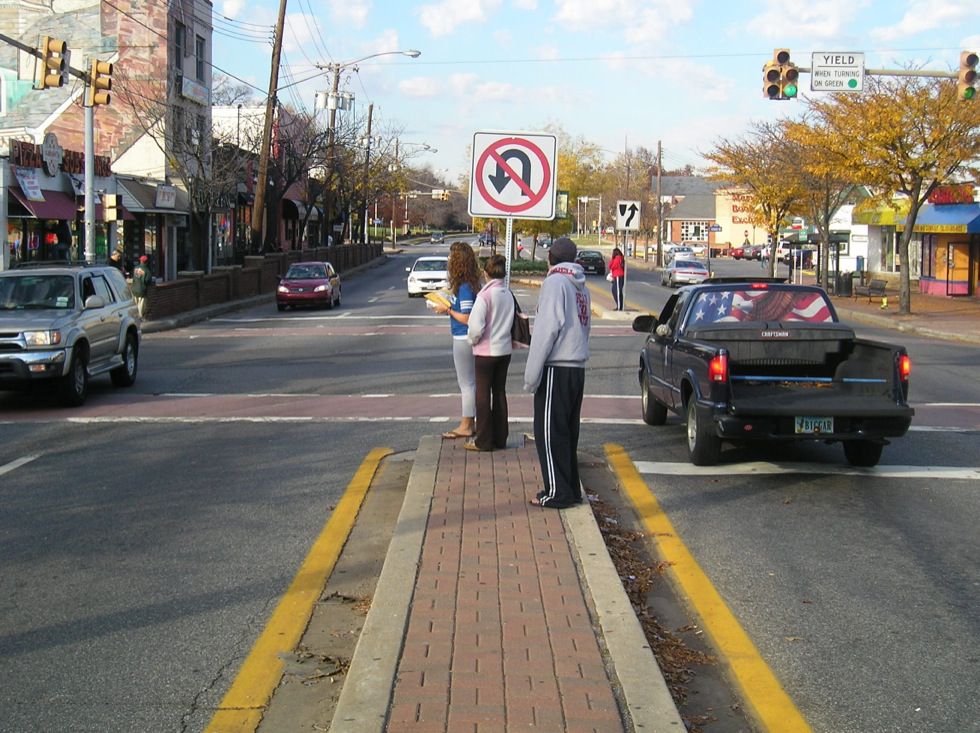
How many of us ended up on the traffic island at signalled intersections?

md-collegepark-11.jpg
From link.

No pedestrian button on the island. Relying on the mercy of someone else in the vicinity. Hoping that it is a pedestrian who presses a button and not a motor vehicle triggering a sensor. Or do we take a chance and cross (if able to, run) the rest of the way?

Some of the streetcar or light rail right-of-ways do have pedestrian buttons, but not the general arterial roads.
 

Back
Top