News   Apr 26, 2024
 161     0 
News   Apr 25, 2024
 424     0 
News   Apr 25, 2024
 1.3K     4 

Ontario Line Extension West of Ontario Place (Speculation)

Thanks, JMI. Anyhow, here's the second and last map I'm going to make that concerns the westward expansion of the Ontario Line (which, as I noted before, I designate as Line 3 in my map series). First, the link...


Now, here's the specific statement concerning Line 3 depicted here:

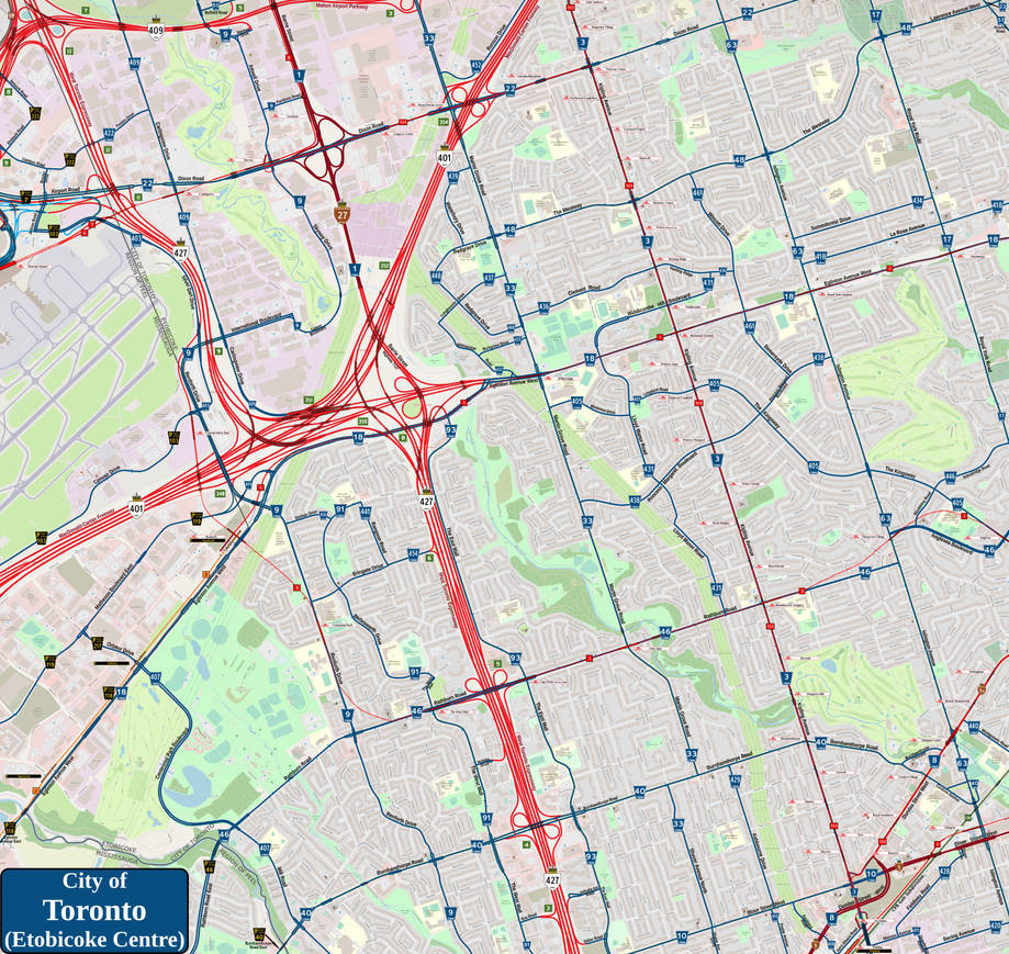
As introduced in the Old Toronto West map, TTC Line 3 (the Ontario Line) will be extended into Etobicoke via Old Mill Station on the Humber River to ultimately connect to Pearson International Airport, thus removing the need to do a hard north turn once TTC Line 5 (the Eglinton Crosstown) is stretched out to Renforth Station. In addition to the extension of Line 5, I also extend TTC Line 6 (the Finch West LRT) south from Humber College along the Barrie Street (Route 1) corridor to the level of Dixon Road (Route 22) before turning west to finally terminate at Pearson Airport's Terminal One with Route 3. Atop that, since I would see the Mississauga Transitway upgraded to a light rail transit line to cross the city of the same name (here known as Peel Region Transit Line 2), this would make Renforth Station a perfect connecting hub for the western end of Toronto.

Thus, the following stations are added...

Line 3 Ontario
Anglesea
: Corner of Anglesea Boulevard (Route 46) and the Kingsway (Route 405)
Thorncrest Village: Corner of Islington Avenue (Route 63) and Anglesea Boulevard
Rosethorn/Saint Gregory: Corner of Kipling Avenue (Route 3) and Rathburn Road (Route 46)
Glen Agar: Corner of Martin Grove Road (Route 33) and Rathburn Road
Capri Park (The East Mall): Corner of The East Mall (Route 93) and Rathburn Road
The West Mall: Corner of The West Mall (Route 91) and Rathburn Road
Centennial Park: Corner of Renforth Drive (Route 9) and Lafferty Street
Renforth: In the area squared off by Renforth Drive, Eglinton Avenue West (Route 18/Peel 118) and Matheson Boulevard (Peel 119)
Convair/Silver Dart: Off Convair Road (Peel 103) west of Renforth Drive
Pearson Airport: Under Pearson Airport's Terminal One complex


BTW, is there a separate chat here that concerns an eastern expansion on the Ontario Line past the Science Centre station?
That list is insane. A bunch of subway stations in the middle of 1950's low-density bungalow sprawl in central Etobicoke??
 
If you think so. Personally, I mirrored what was happening on Line 5 with Line 3 here. Even if the area is residential, people living there deserve better access to the necessities like shopping malls and the like.

And if the number of GOLF COURSES that are in that part of Toronto are eliminated, provoking more urban development...!
h/t to @blacksquirrels for sharing this density map. It seems like a questionable area to focus on providing more transit access to with high capacity service like OL. It would seem to me that, short of being able to upgrade Milton Line to something more approaching rapid transit, it would make more sense to shoot for MCC and Mississauga north of the 403.

icy0ezglcxy91-png.459021
Seems like a decent amount of red around that dundas peel brt project
 
Seems like a decent amount of red around that dundas peel brt project
Hence my turning the Dundas BRT to an LRT on my fantasy maps.

BTW as a heads up to everyone, I'll be incorporating the Don Mills LRT idea into the east/north extension of the Ontario Line. I see it stretching up and over to Finch-Yonge to tie into Line 6, thus making the circle route people have always wanted for Toronto.
 
BTW, is there a separate chat here that concerns an eastern expansion on the Ontario Line past the Science Centre station?
With the provinces plan to keep going up Don Mills to the north (if not north-by-north-west), and then turn west along the 407, I'd think the appropriate thread would be https://urbantoronto.ca/forum/threads/407-transitway.8480/

h/t to @blacksquirrels for sharing this density map. It seems like a questionable area to focus on providing more transit access to with high capacity service like OL. It would seem to me that, short of being able to upgrade Milton Line to something more approaching rapid transit, it would make more sense to shoot for MCC and Mississauga north of the 403.
What an incredible map!. Someone posted a set a few years back, but it was based on the 2006 (or was it 2001?) data. I think there were three versions. Population density, employment density, and a hybrid that tried to tie the two together (which would add low-population places with a lot of jobs, and thus very much deserved transit.

It would be interesting to see how the density is changing over time.

Is there a link somewhere to @blacksquirrels map?
 
If you think so. Personally, I mirrored what was happening on Line 5 with Line 3 here. Even if the area is residential, people living there deserve better access to the necessities like shopping malls and the like.

And if the number of GOLF COURSES that are in that part of Toronto are eliminated, provoking more urban development...!
They don't deserve better access. They chose to buy in an area far from rapid transit. Hopefully some day we get a mayor/council with the balls to break these massive swaths of yellowbelt to get proper density built there. Transit can then follow.

I agree on eliminating those golf courses however. What a joke to have those right in the city.
 
With the provinces plan to keep going up Don Mills to the north (if not north-by-north-west), and then turn west along the 407, I'd think the appropriate thread would be https://urbantoronto.ca/forum/threads/407-transitway.8480/

What an incredible map!. Someone posted a set a few years back, but it was based on the 2006 (or was it 2001?) data. I think there were three versions. Population density, employment density, and a hybrid that tried to tie the two together (which would add low-population places with a lot of jobs, and thus very much deserved transit.

It would be interesting to see how the density is changing over time.

Is there a link somewhere to @blacksquirrels map?

i found it on r/toronto. see the link below. credit goes to u/jamaps for creating it.

 
h/t to @blacksquirrels for sharing this density map. It seems like a questionable area to focus on providing more transit access to with high capacity service like OL. It would seem to me that, short of being able to upgrade Milton Line to something more approaching rapid transit, it would make more sense to shoot for MCC and Mississauga north of the 403.

icy0ezglcxy91-png.459021
I think this also validates the importance of the Jane corridor, going back to Transit City. I still think an Ontario Line west should find some way to Jane subway station (through the park or under South Kingsway), then go straight up. I'd also add a GO for Milton at St. Clair Dundas (call it Lambton) and extend St. Clair streetcar to there.
 
BTW, is there a separate chat here that concerns an eastern expansion on the Ontario Line past the Science Centre station?
With the provinces plan to keep going up Don Mills to the north (if not north-by-north-west), and then turn west along the 407, I'd think the appropriate thread would be https://urbantoronto.ca/forum/threads/407-transitway.8480/

Now that I think about it more, @Pyeknu, there already is a thread for the old Relief Line North study (to Sheppard and beyond!), that was renamed for the Ontario Line north extension.

 
Is there anything we can do to advocate for a roncy/queen street subway? It takes me over an hour to get to my downtown office on a good day and the subway is a 25 minute walk from my place. So much subway development happening in the east end but nothing on the west.
 
Is there anything we can do to advocate for a roncy/queen street subway? It takes me over an hour to get to my downtown office on a good day and the subway is a 25 minute walk from my place. So much subway development happening in the east end but nothing on the west.
Maybe adding a GO station at Queen and Roncey would get you most of the way there! I think part of the reason why we won't and don't see as much interest in subway extensions to the west end is that the GO network has a lot of potential to provide most of that value as GO Expansion comes online. Where would such an extension go that is not just duplicating GO service? Most say up Dufferin or Jane, not further along Queen.
 

Back
Top