News   Jul 12, 2024
 981     0 
News   Jul 12, 2024
 852     0 
News   Jul 12, 2024
 346     0 

Miscellany Toronto Photographs: Then and Now

Here's one for you, moe:

20080220202807Confederation_Life_Bldg_1890.jpg

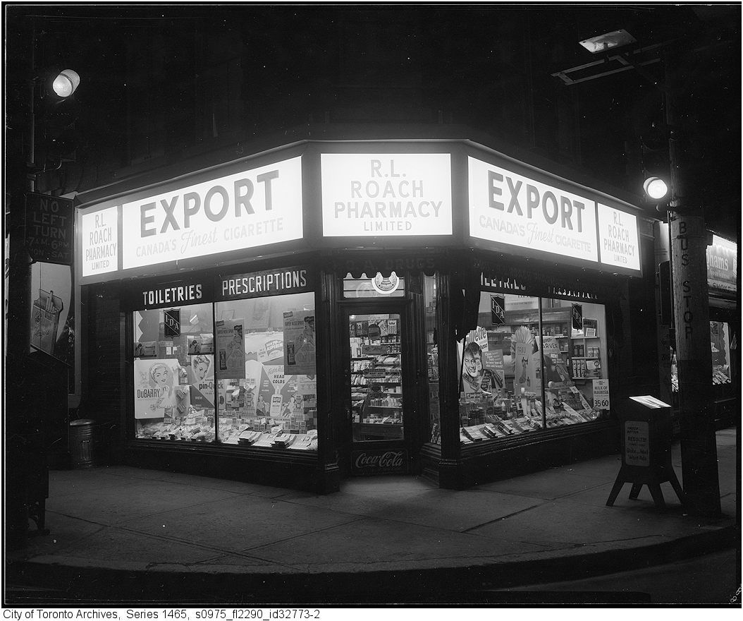
I suppose, in those days, there would be only one call or telegraph per wire.
Now the ether is jammed with yada, yada, yada - and no wires required!

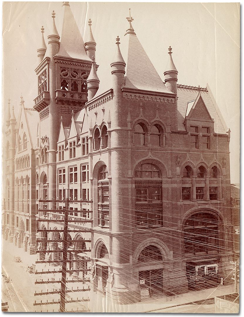
P.S. I love the Confederation Life Building - second only to the Flatiron.
 
The pole line/conductors in the Spadina photo are all Hydro, the pole line/conductors in the photo above are all Telephone, probably circa 1900.
The Telegraph companies had an extensive network downtown at one time but by the 1960's almost all Teletype service was routed through Bell cables on plain ordinary twisted wire pairs just like your phone. A new player has entered the visual pollution game in the last couple of decades, Cable TV, mostly on Hydro poles on main streets.
Bell Canada has very little aerial plant on main streets these days.
 
I remember when they moved it in 1962, when we were living around the corner on Garrick Road. It was 1962? I was five years old, fergawdsake, and I still remember it. The post office is a 1960s government building of mostly uninterrupted brick walls and was about a thousand steps down in style from the building it replaced, but it seems to have held up well.

Thanks Goldie and brewster for injecting a Scarborough viewpoint lately. I used to make the drive from the Beaches where I lived for awhile to Variety Village for various activities and this has shed a lot of light on my Yonge street centric viewpoint of the world. :)
 
Given that the first photos on this thread are Davenport and Ford, and Dundas and Gooch, here are some very early maps of Davenport and vicinity (from Canda's Public Archives), one from around 1800 when it had the name New Road as well as illustrations of very early buildings on Dundas.

http://www.pinet.on.ca/peeldiglib/Page.asp?PageID=3795

http://www.pinet.on.ca/peeldiglib/Page.asp?PageID=3913

http://www.pinet.on.ca/peeldiglib/Page.asp?PageID=3949


Tavern and Toll Booth on Dundas

http://www.pinet.on.ca/peeldiglib/Page.asp?PageID=3863

Love the old fashioned hachure marks to show relief on these maps..
 
"A bit off topic.... " QUOTE moe45673.


Welcome!

I don't see how this is "off topic" at all. Do bear in mind that most of those lines were telephone/telegraph lines.

I recall being in a client's office on Spadina Road during the 80's and listening to the CNCP teletype machine

hammering away in a closet beneath a stair. After having mentioned to one of the company's principals that the

teletype thingy was to be a dead medium and soon to be replaced by one that could send/recieve actual hard

copy as in contracts from New York/LA, he looked at me as if I were nuts. We now call it a Fax.


Regards,
J T

There's quite a segment of over 75s in this city that rely on fax machines - they attach to a phone so they are easy to implement - my father-in-law exchanges lots of documents with his late adopter of technology friends this way. :)
 
Last edited:
That was a test. Now I know how to use the BB Code. I know it is simple for most people but for me I feel like a rocket scientist when I figure something out.
 
Given that the first photos on this thread are Davenport and Ford, and Dundas and Gooch, here are some very early maps of Davenport and vicinity (from Canda's Public Archives), one from around 1800 when it had the name New Road as well as illustrations of very early buildings on Dundas.

http://www.pinet.on.ca/peeldiglib/Page.asp?PageID=3949

]

I wonder where the author of this map; Lt. Hawkes; has placed/identified the 'Good Water Supply' in the Yonge and St. Clair area. St. Michaels Cemetery is in that area... and even in 1869 military authorities always sought the purest sources of water farthest from possible contamination.
 
And not only are we relieved for you but we are also thankful. :)

You are a kind man Mustapha and now back to Scarborough for a bit.

LILY CUP by Mr T.O., on Flickr


BIRCHMOUNTFIREHALL by Mr T.O., on Flickr


194Randell by Mr T.O., on Flickr


117-119EastvilleAvenue1950-2010-1 by Mr T.O., on Flickr


Looking Across the street at 117 Eastville Ave. by Mr T.O., on Flickr


Eglinton & Kingston Road looking East by Mr T.O., on Flickr


BELL ESTATE --EAST OF WARDEN , SOUTH OF ST.CLAIR by Mr T.O., on Flickr


BACKOF1469KINGSTONROAD3 by Mr T.O., on Flickr


8QUEENSBURY by Mr T.O., on Flickr


777dan by Mr T.O., on Flickr


Danforth Road by Mr T.O., on Flickr


3790KingstonRoad by Mr T.O., on Flickr


3121eglinton by Mr T.O., on Flickr


3-5-7-9-ChipperCresent by Mr T.O., on Flickr


20CLIFFCREST1960-2010 by Mr T.O., on Flickr
 
Then and Now for Sep 12.


Then. Back to the Toronto Archive pics.. 'Roach's Drugstore Export sign at night. April 9, 1956'. Carlton and Church SE corner.

175PhotoofExportsignonRoachsdrugstoreatnightApr91956.jpg


Now. May 2011.

176.jpg


I love these occasional night time shots. They are so atmospheric. :) My dad and his mom - my granny - smoked Exports. Gramps smoked Players Mediums. I think it stunted me.
 

Back
Top