News   Sep 06, 2024
 243     1 
News   Sep 06, 2024
 924     6 
News   Sep 06, 2024
 465     0 

Mass/rapid transit..........................what would you do?

To add to the map collection on this thread, here is a map I just made showing what percent of commuters travel to work by public transit each day
Great map! But what's the data source? 2000? 2001 census? 2006 census?

This are origins I assume. Are destinations available? What about pairs?
 
Great map! But what's the data source? 2000? 2001 census? 2006 census?

This are origins I assume. Are destinations available? What about pairs?

It's from the 2006 Canadian census. The census asks a "how do you get to work question," but it doesn't have anything on destinations. The city does have transit studies with that info, but I'm not sure where one would find that.
 
What ties any/all of these maps together tends to be the presence or absence of apartment/condo towers. The income of one yuppie living in an apartment can't really compete with the income of two married yuppies (DINKs, I guess) living in a house, for example. A family of 4 living in an apartment is probably not oging to have the 4 cars necessary to take everyone where they need to go, but a house in the Kingsway might. Then there's the hordes of people that move to apartments near good transit because of the good transit...there's relatively few of these apartments in a spot like the Yonge/Bayview/Leslie zone between Eglinton and Sheppard, which does hurt the transit usage of the Lawrence/York Mills areas despite good transit. That commuting map also excludes travel for school (unless kids are counted as commuters), shopping, leisure, by 905ers, etc., so it can hardly be taken as a measure of total transit trips.

Some commie blocks give other commie blocks a bad name. There are some very attractive, even whimsical, slabs out there, some that have aged well...but there are lots of real beasts and some that are falling to pieces.

Don't forget that there are other close-to-the-subway tower clusters which haven't fared as badly--that at High Park, or those near Davisville and Eglinton. (Or, if you want, everything off Yonge south of Bloor.)

I'm not forgetting them. They tend to be far more integrated with both the surrounding housing tracts and the local main streets, for one thing. Another thing is demographics...race, income, class, etc. Demographics are the elephant in the room that we like to ignore, lest the argument turn into, well, you know what happens. If you took Flemingdon Park and Leaside and swapped all the residents, Flemingdon Park would not be 'troubled' and Leaside would be filled with urban youths. That's a main reason why running light rail out to 'troubled' areas is such a stupid basis for transit expansion - demographics can change quickly. Malvern, for instance, is no longer 'troubled' when you're comparing it with the actual rest of the city and looking at reality instead of reputation.

You know, I have absolutely no idea what a commie block is. Are we talking political institutions here?

Perhaps you can talk English?

Perhaps you can do the forum a favour and set your ignore feature to 'All Users'?
 
What ties any/all of these maps together tends to be the presence or absence of apartment/condo towers.

It's interesting to look at Toronto's tower neighbourhoods, as the transit patterns are very different based on what part of town they're in. Here's a look at Toronto's 20 densest areas, arranged by the percent of people who commute by car:

  1. The Village (West half) - 22809 people/km - 14.7% commute by car
  2. Bay Street Corridor - 43518 - 17.9%
  3. The Village (East half) - 26513 - 18.7%
  4. St James Town - 63765 people/km - 19.2%
  5. Carlton and Sherbourne - 21576 - 23.4%
  6. Regent Park - 22450 - 24.5%
  7. South Parkdale - 20179 - 27.3%
  8. Deer Park - 31486 - 29.9%
  9. Yonge and Eglinton - 26516 - 32.5%
  10. Davisville - 24088 - 33.3%
  11. High Park North - 24008 - 33.9%
  12. High Park North - 36033 - 34.5%
  13. Crescent Town - 20393 - 38%
  14. Thorncliffe Park - 21236 - 42.2
  15. Islington - 21250 - 42.5
  16. North York City Centre - 37239 - 44
  17. Flemingdon Park - 21517 - 51
  18. Milliken - 33367 - 62.8
  19. Kingsview Village - 21610 - 66.2
  20. Milliken - 19627 - 71.6

Despite the great differences in income, history, and subway access, it's odd how close this is to just being a list of how far an area is from the core of the city. Bay Street condo or St. James Town comie block, if you live right downtown your most likely walking to work. A Midtowner and a Parkdalian are both most likely going to be taking transit, with a one in three chance of driving. Once in the suburbs even a subway right at the door only convinces about half of people in North York City Centre and Islington to take transit, about the same number as subwayless Thorncliffe and Flemingdon Park.
 
Why has nobody mentioned GO transit improvements?

Brampton is already in the bag. 30 minute off-peak headways on that line please.

Same with Milton (to somewhere in Mississauga), Barrie (to newmarket), and Stouffville (to Unionville).Also increase service on lakeshore E&W. All day train service to Hamilton. All these lines must add a station at Eglinton Avenue if possible.

Then, Eglinton LRT.

All I have to say is 15 min off peak for the Lakeshore Line.
 
What ties any/all of these maps together tends to be the presence or absence of apartment/condo towers. The income of one yuppie living in an apartment can't really compete with the income of two married yuppies (DINKs, I guess) living in a house, for example. A family of 4 living in an apartment is probably not oging to have the 4 cars necessary to take everyone where they need to go, but a house in the Kingsway might. Then there's the hordes of people that move to apartments near good transit because of the good transit...there's relatively few of these apartments in a spot like the Yonge/Bayview/Leslie zone between Eglinton and Sheppard, which does hurt the transit usage of the Lawrence/York Mills areas despite good transit. That commuting map also excludes travel for school (unless kids are counted as commuters), shopping, leisure, by 905ers, etc., so it can hardly be taken as a measure of total transit trips.

Some commie blocks give other commie blocks a bad name. There are some very attractive, even whimsical, slabs out there, some that have aged well...but there are lots of real beasts and some that are falling to pieces.
What's a commie block? Do you have a specific example from Toronto? Is it an urban ghetto? Or an unappealing astectic?
 
What's a commie block? Do you have a specific example from Toronto? Is it an urban ghetto? Or an unappealing astectic?

Explained/discussed in the previous page of the thread. And as I suggested, the term's more affectionate than derisive these days--at least in Toronto, where said affection influenced this initiative in part...
 
I still have to say, that that traditional Ontario apartment building has never reminded me of what you see behind the iron curtain. It didn't make me think that in the 1970s, and it doesn't know. When I see it, I think Ontario ... not Warsaw Pact.
 
But it's a freestanding Modernist high-rise, and that's all that matters--and remember that to non-Torontonians on skyscraper forums, that simple parti is *heavily* associated with the Eastern Bloc, or China, or Parisian banlieue (where the French Communists found a lot of their erstwhile electoral strength). Just like how a century or so ago, apartment buildings which looked like nothing you'd find in France were commonly called "French flats".

So, really: it doesn't matter what it makes you think of--after all, if you "think Ontario", it's natural, because you're *from* Ontario, and you've lived with them all your life. You're biased. (Though that might be an argument for alternative terminology like "Toronto Block"...)
 
Explained/discussed in the previous page of the thread. And as I suggested, the term's more affectionate than derisive these days--at least in Toronto, where said affection influenced this initiative in part...
I didn't really see an explaination, but I didn't look too deep past the bickering. I figured it was easier to ask, because there isn't anything I've seen in Canada that's very comparible to apartment complexes I've seen in Azerbaijan, Armenia, Georgia, and various-stans. In Azeribaijan for example, they've painted the raw concrete exteriors in bright primary colours and it makes a huge difference. Because I've seen a variety in finish and time period and colour, I wanted to know which period/style/country is meant by "commie block" or easier a picture is worth a thousand words.
 
back to the transit thread, again................
I do have some empathy with Metrolinx. It's difficult to help improve rapid transit in Toronto when the system is so small.........everyone in all areas of the city want their peace of the pie and who can blame them? Toronto has done basically nothing for a quarter of a century and it has so much catching up to do. I do applaud them for wanting to get shovels in the ground immediately especially on the Eglinton line and even if it ends up being subway the construction will have already begun.
The two big boys on the block are Eginton and the DRL but thanks to Miller it wasn't put into the TTC plan although only god knows why. By promising all other areas of the city something when the first phase of whatever is built by 2020 it will be the other area residents who will now demand the lines they were promised but were delayed and they will have a good point. Jane, Don Mills, Miminco, Kingston, and the completion of the Eglinton will be next on the list. If this is the case then the DRL could have to wait more than 20 years before it is even considered. Miller's plan will only dump more people onto the existing subway lines, have a completely disjointed slow system that Torontonians will not embrace and certainly not consider rapid transit.
 
I didn't really see an explaination, but I didn't look too deep past the bickering. I figured it was easier to ask, because there isn't anything I've seen in Canada that's very comparible to apartment complexes I've seen in Azerbaijan, Armenia, Georgia, and various-stans. In Azeribaijan for example, they've painted the raw concrete exteriors in bright primary colours and it makes a huge difference. Because I've seen a variety in finish and time period and colour, I wanted to know which period/style/country is meant by "commie block" or easier a picture is worth a thousand words.

It probably all started (the term, not the genre) when these became trendy places to live it after the fall of the Wall.

Under the circumstance, it's useless to split hairs over whether some are more "colourful" than others. By and large, one could call them "Corbu blocks" (after Le Corbusier, who's commonly associated with this kind of planning); but somehow, "commie block" caught on within the internationalist world of skyscraper forums...
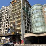
 
"commie block" caught on within the internationalist world of skyscraper forums...
internationalist world of skyscraper forums?? Alrighty now ...

So the defining features is the prefabricated concrete slabs? Is that how apartment buildings in Toronto were built in the 1970s? I always had assumed they were poured in-situ.
 
Prefabricated, in situ--doesn't matter. They're high-rise, free-standing, and "Corbusian". And, myth has it, commie states built them by the acre. Ergo, "commie block".

Then again, maybe I'd have to define "Corbusian" for you all; in which case, it's a no-win situation...
 

Back
Top