New here. Hope this is ok if I attribute the pic I've posted; it's watermarked anyhow... I've seen lots of pics from the city of Toronto archives ... York University too, has a nice resource in its collection of Toronto Telegram photos.
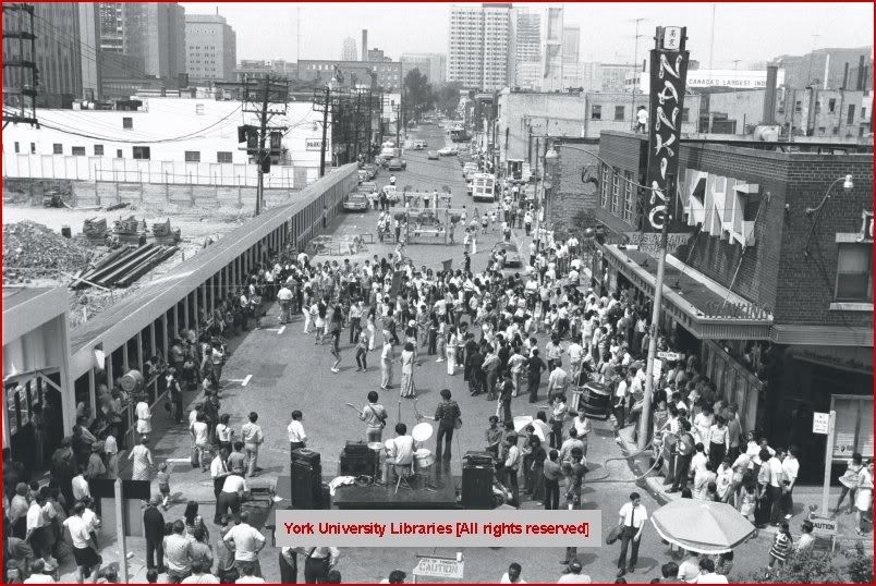
This photo is poignant - the last hurrah of Toronto's Elizabeth Street Chinatown. I was at this event. Can't prove it.
")
tho'. The lower half of Elizabeth had already disappeared for the New City Hall. In 1974 the Gerrard Chinatown hadn't jelled yet, and Spadina Chinatown was just seeing its first Chinese business tenants.
The clearance on the left was for the Holiday Inn, now a student residence. The Nanking restaurant is now overflow offices for a City of Toronto department.
If anyone wants to experience old Chinatown ghosts, this stretch of street is worth a visit - just a skip from the Eaton Centre. There is a Chinese restaurant at the SW corner of Elizabeth and Dundas west/2nd floor. This was formerly the old 'Kwong Chow' - circa 1950 to 1980 - guessing at the dates here.
It's also hard to believe that there was a thriving Chinatown on York Street circa 1910 to 1940, of which no pics seem to exist (online, anyways). Grandpappy mentioned this to me.
There is a new plaque in Nathan Phillips Square commemorating this lost neighbourhood. Sad too that when this Chinatown went under the wreckers ball, the old denizens of the disappeared neighbourhood (senior citizens mostly) would still go sit in the same location ... an area near the skate rental/public toilets.