News   Apr 18, 2024
 583     0 
News   Apr 18, 2024
 4.9K     1 
News   Apr 18, 2024
 2.3K     4 

Lost Road and Bridge: Lawrence Avenue

The Get Toronto Moving site actually has an aerial photo of just what that looked like. :) It's not as great as some shot on the spot, but it's still useful to see it as an overall reference. And you can see that "our" house still has its driveway connection to Woodbine in the shot...

Gardiner-DVP_UC_20_zpsdfbfc8d4.gif

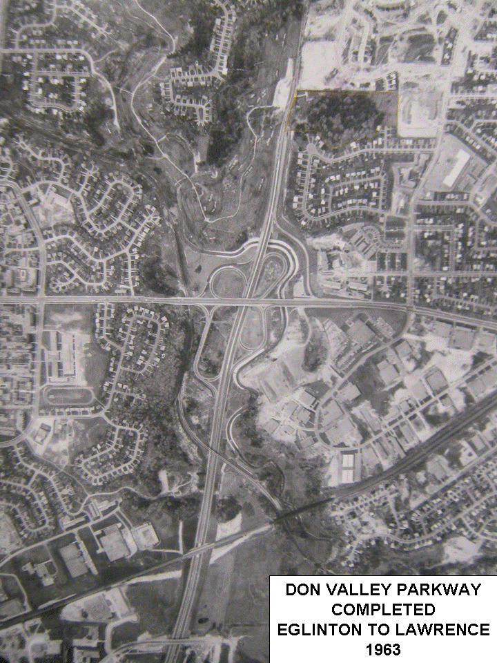
Very nice! And what I assume was all of the Greenans' property has been outlined in yellow, showing what was sold to the Del Zottos for development. The voters lists had Red Willow ending at no. 11 in 1968. By 1972 it had been completed to no. 51, and Geraldine Court & Lia Crescent were there as well.
 
Last edited:
Here are a couple more satellite shots of 6 Geraldine Court.

6 Geraldine Court, 2013.jpg


1953
6 Geraldine Ct (1953).jpg

http://jpeg2000.eloquent-systems.com/toronto.html?image=ser12/s0012_fl1953_it0101.jp2

1957
6 Geraldine Ct  (1957).jpg

http://jpeg2000.eloquent-systems.com/toronto.html?image=ser12/s0012_fl1957_it0070.jp2

https://maps.google.ca/maps?ll=43.746326,-79.331382&spn=0.001635,0.003484&gl=ca&t=h&z=19

The home has been there since at least 1953. It's difficult to make out if anything was there in the 1947 satellite shot. I know that, Henry Fliess, built at least half a dozen custom homes in the area -- I wonder if this is one of them?
 

Attachments

  • 6 Geraldine Court, 2013.jpg
    6 Geraldine Court, 2013.jpg
    86.9 KB · Views: 2,562
  • 6 Geraldine Ct (1953).jpg
    6 Geraldine Ct (1953).jpg
    98.4 KB · Views: 2,417
  • 6 Geraldine Ct  (1957).jpg
    6 Geraldine Ct (1957).jpg
    96.1 KB · Views: 2,617
Last edited:
Here are a couple more satellite shots of 6 Geraldine Court.

View attachment 18218

1953
View attachment 18219
http://jpeg2000.eloquent-systems.com/toronto.html?image=ser12/s0012_fl1953_it0101.jp2

1957
View attachment 18220
http://jpeg2000.eloquent-systems.com/toronto.html?image=ser12/s0012_fl1957_it0070.jp2

https://maps.google.ca/maps?ll=43.746326,-79.331382&spn=0.001635,0.003484&gl=ca&t=h&z=19

The home has been there since at least 1953. It's difficult to make out if anything was there in the 1947 satellite shot. I know that, Henry Fliess, built at least half a dozen custom homes in the area -- I wonder if this is one of them?

No satellites in 1947. It would be an airplane shot.
 
No satellites in 1947. It would be an airplane shot.

Yeah, I meant to write aerial shot. On a different note -- Delzotto (sp?) really messed up the landscape. There's only a sliver of that ravine that still exists.

Speaking of satellite shots -- does anyone know when Google Maps will update their Toronto satellite imagery? It's been over 4 years since the last update. Many of the other major cities, in the country, have been updated and now include bird's eye view. It would be really nice to see some updated imagery; considering all the development that has taken place since the last update. Who could I contact to find out when the next update will come? Would anyone at Toronto's Google headquarters know?
 
Last edited:
Interesting, because I did some research too.:eek:

I took a look at some old Voters Lists and the Toronto Star.
In 1953 , what I thought was 'our' house was occupied by John Greenan, mechanical engineer, and his wife Margaret. Their address was RR1 Todmorden. By 1963 their address was 'Woodbine Ave' and they were included in the polling station for Three Valleys Drive. John F Greenan was the President of Don Valley Building Ltd. and Universal Plumbing & Heating Co.

"The first office building to be erected in Don Mills is to get underway immediately. The four-storey building located south of Lawrence Ave E and west of Donway West, will contain 30,000 square feet of rentable space. It is to be called Don Valley building and will be operated by Don Valley Building Ltd."

In 1965, at age 45, Mary Margaret Greenan was killed when she lost control of her sports car on the Don Valley Parkway south of Eglinton. At that time she was living on Brimley Road. John Greenan died in 1970.

I couldn't find the house in the 1965 and 1968 voters lists, although I thought I found the right polling station. But I did find it in 1972, with the address 6 Geraldine Court, and was occupied by Gordon Hall (self-employed) and Lillian Hall.

I don't know if this series is still available anywhere, but there used to be a show called wojek and one of the episodes had John Vernon on a crusade to expose the dangers of the DVP when it first opened. Not sure if he was looking for center medians or Armco for the sides of the parkway so that cars could not swerve into the ditches....Just a vague memory. Obviously, I did not see this show in its original run. But in reruns. It was always way cool to see some scenery from sixties Toronto.....
 
I don't know if this series is still available anywhere, but there used to be a show called wojek and one of the episodes had John Vernon on a crusade to expose the dangers of the DVP when it first opened. Not sure if he was looking for center medians or Armco for the sides of the parkway so that cars could not swerve into the ditches....Just a vague memory. Obviously, I did not see this show in its original run. But in reruns. It was always way cool to see some scenery from sixties Toronto.....

Wojeck, CBC-TV series broadcast from 1966 to 1968.

A scene being filmed on the DVP:

Wojeck1966-68_zps5a0d2af9.jpg
 
well, I'll be!!!!
that must be near the old Domtar plant....
what an archive you must have!!

Can you imagine an exposed lamp post on the dvp now??
What was the speed limit in those days??
 
Last edited:
I don't know if this series is still available anywhere, but there used to be a show called wojek and one of the episodes had John Vernon on a crusade to expose the dangers of the DVP when it first opened. Not sure if he was looking for center medians or Armco for the sides of the parkway so that cars could not swerve into the ditches....Just a vague memory. Obviously, I did not see this show in its original run. But in reruns. It was always way cool to see some scenery from sixties Toronto.....

Wojeck was 'inspired by' Morton Shulman.

from Wikipedia:eek:
In 1965, Metro Toronto Chief Coroner Morton Shulman released a report criticizing the lack of safety in the design of the parkway. In the first five months of 1965, there were 136 accidents on the parkway, with four deaths and 86 injuries. Among the "death-dealing" deficiencies that had to be corrected were inadequate guardrails, exposed steep slopes and light standards that were exposed to collision from passing high-speed traffic. Call boxes with emergency telephones were installed on the parkway in 1966. The boxes, attached to street lighting on the right shoulder, provided a direct line for help from the Ontario Motor League, now part of the Canadian Automobile Association (CAA). Today, the RESCU Traffic Management System monitors the highway and can call for emergency help.
 
I was sent this information via email yesterday evening:

Untitled.jpg


According to this document, the house was built in 1969. Based on aerial photos in the Toronto Archives, this is easily proven to be false. We've established that the house was built between 1947 and 1953. I believe the mix up in dating this house is due to the fact that when it was built it stood alone, located on rural land, abutting a former ravine; Geraldine Ct and Lia Cr didn't exist for at least a decade after this house was completed. Originally, this house must have had a Woodbine Ave address (as was noted earlier in this thread). If one compares pre 1971 aerial photos in the archives to the most recent satellite photos of this property they will notice that a rear addition and garage were added between 1962 and 1971 (see comparison below). I'm guessing that this happened in 1969, and is the first record of anything being built on this property under the address: 6 Geraldine Ct. Does that make sense? Where else would the 1969 figure come from? The house was definitely not demolished; the existing structure was merely enlarged.

1962:
1962.jpg


1971:
1971.jpg


Present Day:
Untitled3.jpg
 

Attachments

  • Untitled.jpg
    Untitled.jpg
    76.7 KB · Views: 2,184
  • 1962.jpg
    1962.jpg
    98.8 KB · Views: 1,696
  • 1971.jpg
    1971.jpg
    102.7 KB · Views: 1,694
  • Untitled3.jpg
    Untitled3.jpg
    100.9 KB · Views: 1,660
Last edited:
Well the irony is that the current owners of Geraldine Ct and Lia Cr houses have issues of basement flooding (according to a friend of mine that used to live on Redwillow Dr). I guess that is due to the fact that these properties stand on the site of a former ravine, which had multiple streams; now buried (as is noticeable in the old aerial photos; one of which still exists at ground level, just north of Doonaree). So in a sense, these houses are built on water.
 
I'm trying to figure out the original address of 6 Geraldine Ct based on where the main section of Woodbine Ave ended, and where its northern extension began, prior to the construction of the DVP. So Woodbine terminated at O'Connor Dr (currently Trillium Apartments, 1501 Woodbine Ave - Year: 1968, ref TOBuilt). Where did its northern portion begin; at Old Lawrence Ave, or adjacent to 6 Geraldine Ct?

Here is a 1953 aerial photo showing the Woodbine & O'Connor intersection: http://jpeg2000.eloquent-systems.com/toronto.html?image=ser12/s0012_fl1953_it0156.jp2 It appears that those houses, directly south of the that building (any idea what that building was?), which was replaced with the Trillium Apartments in 1968, still exist. Here is a current streetview image of the last house on Woodbine Ave (#1437): https://www.google.ca/maps/@43.69908,-79.318574,3a,75y,53h,83.42t/data=!3m4!1e1!3m2!1sv22jwD7M2JpXDv9e3hdtvA!2e0. Its neighbour, the RPM Services building (1441 Woodbine Ave), appears to have been a house at one point. Do you suppose that the building that previously occupied the Trillium Apartments (1501 Woodbine Ave) site had the same address? And why would there be such a large gap between street numbers of adjacent properties? If 6 Geraldine Ct originally had a Woodbine Ave address, as we believe, wouldn't that put its street number between 1441 and 1503 (that is if the current addresses of these properties never changed between 1953 and now). Judging by the retro style of the address numbers on 1437, its safe to assume that that's its original address.
 
Last edited:

Back
Top