News   May 01, 2024
 1.2K     1 
News   May 01, 2024
 340     0 
News   May 01, 2024
 357     0 

Lost Road and Bridge: Lawrence Avenue

Boy, I'd like to take a sec and really thank all you folks. Your research and photographic skills have shown me things this week about the history of this little part of town that I really never imagined I'd see. And the best part is, it's here for other people like us; maybe years from now.

It's been a great adventure for all of us.
We owe a debt of gratitude to Lone Primate for initiating this adventure with his "mysterious" 1960 photo of Woodbine.
House at the end of Woodbine, 1960, plate 151.jpg
 

Attachments

  • House at the end of Woodbine, 1960, plate 151.jpg
    House at the end of Woodbine, 1960, plate 151.jpg
    96.4 KB · Views: 935
The boundary between the newly-created cities of Mississauga and Brampton was established at the hydro corridor running between them when Peel Region was inaugurated in 1974. But Steeles was once the north boundary of Toronto Township, which became the Town of Mississauga in 1968.

Since this thread is back from the dead, I can now post my wonder at why the hydro corridor was not adjusted to become the border between Metro Toronto and York Region as well. It would have made a more logical boundary.
 
Since this thread is back from the dead, I can now post my wonder at why the hydro corridor was not adjusted to become the border between Metro Toronto and York Region as well. It would have made a more logical boundary.

My guess is just that because Steeles had, for whatever reason, long formed the northern boundaries of Etobicoke, North York, and Scarborough, it was probably just easier to draw a harder line there. I guess the same argument could have been made for Mississauga, though. Kind of arbitrary. Sometimes it's based on who can best service something, though. That's why Scarborough eventually got Port Union... because it was easier for Metro to service it than Durham. Same with the part of Halton cut off by the 407; that was ceded to Mississauga a couple of years ago because Mississauga can service it from Ninth Line, but it's next to impossible for Milton to service the strip because the 407 is completely in the way. Hard to make the same case for Brampton getting the north part of Mississauga (including Churchville) though. Interesting question.
 
Here's a Toronto "cryptoroad" if there ever was one:

I remember hearing once (but have never found any official sources) that there was once a plan way back to link Wilson Ave and Rexdale Blvd. together but the plans were dropped due to public opposition. That probably explains the weird course correction of Albion Road after it crosses the Humber. If you look at these pics, you can see how such a link could have run:

rexdale2.jpg


Bergamot Ave., east of Islington, is a smallish street with four lanes that ends abruptly just after a side street as if it were intended to continue as major road. This I'm sure would have been part of the (now-missing) link:

Untitled2.jpg


Untitled.jpg
 

Attachments

  • rexdale.jpg
    rexdale.jpg
    20.8 KB · Views: 599
  • rexdale2.jpg
    rexdale2.jpg
    105.6 KB · Views: 1,289
  • Untitled2.jpg
    Untitled2.jpg
    95.6 KB · Views: 966
  • Untitled.jpg
    Untitled.jpg
    94.9 KB · Views: 881
My guess is just that because Steeles had, for whatever reason, long formed the northern boundaries of Etobicoke, North York, and Scarborough, it was probably just easier to draw a harder line there. I guess the same argument could have been made for Mississauga, though. Kind of arbitrary. Sometimes it's based on who can best service something, though. That's why Scarborough eventually got Port Union... because it was easier for Metro to service it than Durham. Same with the part of Halton cut off by the 407; that was ceded to Mississauga a couple of years ago because Mississauga can service it from Ninth Line, but it's next to impossible for Milton to service the strip because the 407 is completely in the way. Hard to make the same case for Brampton getting the north part of Mississauga (including Churchville) though. Interesting question.

That seems about right. Do you know when was the Finch Corridor built exactly? All I could find online was that it was constructed sometime "in the 1950's." Could it just be that it wasn't even around yet when Metro was formed in 1954?
 
That seems about right. Do you know when was the Finch Corridor built exactly? All I could find online was that it was constructed sometime "in the 1950's." Could it just be that it wasn't even around yet when Metro was formed in 1954?

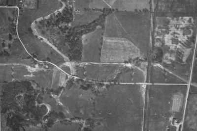
I'm not sure when the hydro corridor went in but I happened to have a shot from 1953 handy that shows it existed along (Old) Cummer Avenue in 1953. Odds are it had been there for a while because there don't seem to be any signs of recent construction around them. Arguably it existed to have formed a border in York the same way the similar line did in Peel.

1953%20-%2020a.jpg


Just going out on a limb, I'd say it comes down to proximity. By the 1950s there was already some development north of Finch in Etobicoke and North York, at least. There wasn't much north of Steeles to stake a better claim in the early 1950s, so rejigging the municipal boundaries probably didn't bear much consideration.

But in Peel by the early 1970s, the core of Brampton, centred on Queen Street, was considerably closer to Steeles than development in Mississauga, where serious work was only just vaulting across Eglinton at the time, and I imagine the politicos of the prospective City of Brampton probably argued persuasively that a little more elbow room for Brampton's eventual growth was justified. And it probably didn't hurt that the premier of the day was Brampton Bill. :)
 
Last edited:
Here's a Toronto "cryptoroad" if there ever was one:

I remember hearing once (but have never found any official sources) that there was once a plan way back to link Wilson Ave and Rexdale Blvd. together but the plans were dropped due to public opposition. That probably explains the weird course correction of Albion Road after it crosses the Humber.

I'd heard something about the plan to link up Rexdale and Sheppard, since they both dead-end; the first at Islington and the second at Weston; by means of using Bergamot. Naturally that would have included a Rexdale-Albion intersection as well. But you make a pretty good case here.
 
Incidentally, I think the actual plan at the Humber would not have been an Albion-Rexdale "T" intersection, but a Kingston-Danforth-type split--which also explains the former NW-bound vs SE-bound Albion lane alignment...
 
Where are these photos? It is hard to tell and it does not say.

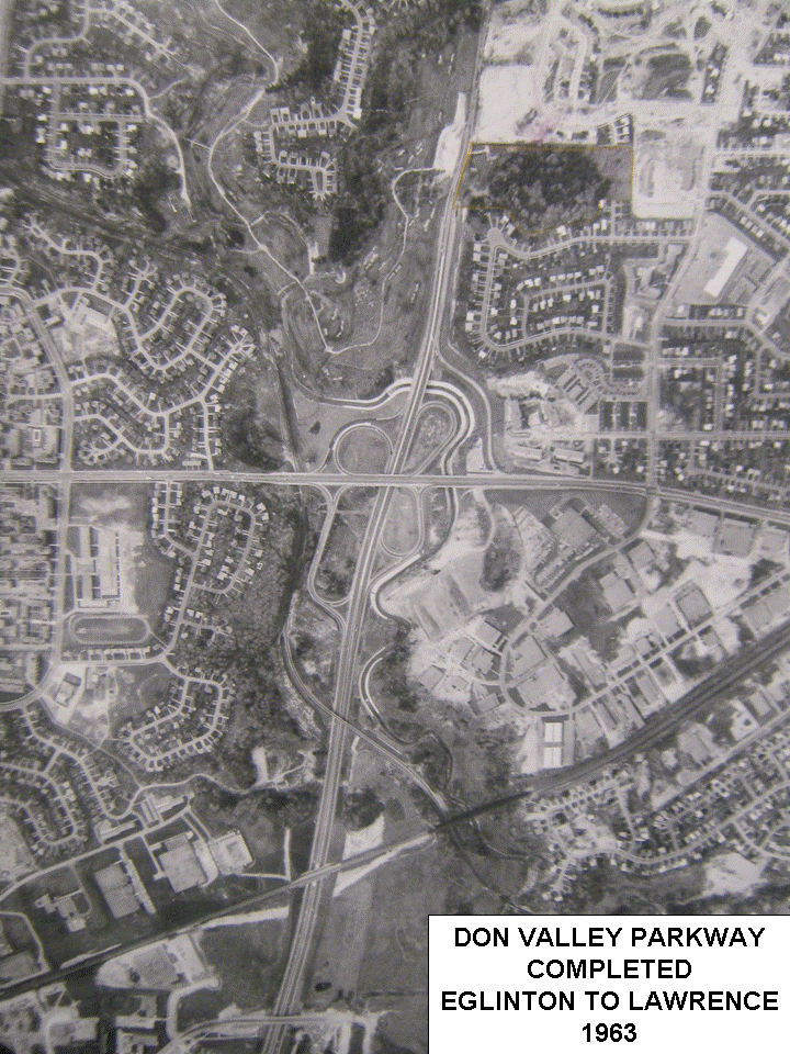
They're referenced earlier in the thread. They're pretty much where the DVP ended and merged with Woodbine Avenue north of Lawrence Avenue for about three years from 1963-1966. The first view looks north toward Woodbine and the second, south from Woodbine to the opening DVP.
 
Here's a Toronto "cryptoroad" if there ever was one:

I remember hearing once (but have never found any official sources) that there was once a plan way back to link Wilson Ave and Rexdale Blvd. together but the plans were dropped due to public opposition. That probably explains the weird course correction of Albion Road after it crosses the Humber. If you look at these pics, you can see how such a link could have run:

View attachment 11789

I think I found reference to that in an old Toronto Star and mentioned and/or posted it here somewhere.
 
Where are these photos? It is hard to tell and it does not say.

The Get Toronto Moving site actually has an aerial photo of just what that looked like. :) It's not as great as some shot on the spot, but it's still useful to see it as an overall reference. And you can see that "our" house still has its driveway connection to Woodbine in the shot...

Gardiner-DVP_UC_20_zpsdfbfc8d4.gif
 
Sept 28 1971
Sept 28 1971.JPG

July 31 1979
Jul 31 1979.jpg
 

Attachments

  • Jul 31 1979.jpg
    Jul 31 1979.jpg
    53.4 KB · Views: 795
  • Mar 21 1972.JPG
    Mar 21 1972.JPG
    49.3 KB · Views: 568
  • Sept 28 1971.JPG
    Sept 28 1971.JPG
    37.4 KB · Views: 839

Back
Top