

Brandon716
Senior Member
Windows Live Local has central Toronto mapped out pretty well, although they totally lack many GTA centres such as Mississauga, Scarborough, and even lack most of the buildings in North York (although they have the New York towers and a few by the 401).
With that said, for those of you with the ability you should fly over to the 3D maps and take a spin, you can get detailed 3D virtual worlds of central Toronto:
http://local.live.com/
Just switch it to 3D, let it install if it needs, switch to hybrid, and zoom in on your city of choice (Toronto of course!)")
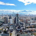
With that said, here are a few 3D views of Toronto.
Downtown looking southeast from the northwest:

Downtown looking west-southwest from the east:

Looking north-northwest away from downtown toward midtown:

Several kilometers north looking back south toward downtown from Yonge-Eglinton (7km, 4.5 miles):

Way northwest of downtown-midtown-yonge & eglinton looking back southwest (about 13 miles out of the city):

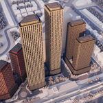
You can also see detailed models of local blocks.
Dundas Square:

Nathan Phillips Square/City Hall:

So load it up, and have some fun!
http://local.live.com/
With that said, for those of you with the ability you should fly over to the 3D maps and take a spin, you can get detailed 3D virtual worlds of central Toronto:
http://local.live.com/
Just switch it to 3D, let it install if it needs, switch to hybrid, and zoom in on your city of choice (Toronto of course!)
With that said, here are a few 3D views of Toronto.
Downtown looking southeast from the northwest:
Downtown looking west-southwest from the east:
Looking north-northwest away from downtown toward midtown:
Several kilometers north looking back south toward downtown from Yonge-Eglinton (7km, 4.5 miles):
Way northwest of downtown-midtown-yonge & eglinton looking back southwest (about 13 miles out of the city):
You can also see detailed models of local blocks.
Dundas Square:
Nathan Phillips Square/City Hall:
So load it up, and have some fun!
http://local.live.com/