News   Jul 15, 2024
 777     3 
News   Jul 15, 2024
 922     1 
News   Jul 15, 2024
 640     0 

Don Valley: An Urban Park?

Second_in_pie

Senior Member
Member Bio
Joined
Mar 1, 2009
Messages
2,212
Reaction score
2
Location
Markham
Today, I was biking down Don Valley while pathetically trying to find the belt line bike path (I never found it) and I thought for a second, trying to imagine the area around the valley fully developed, with condos and apartments, maybe some office buildings, then I thought something: The Don Valley is never going to get developed.

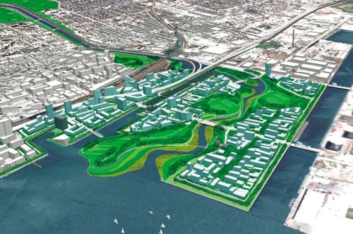
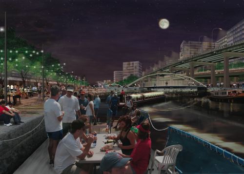
People don't want it to happen. It's natural land, and should always stay that way. I agree entirely, but something should happen to it as the downtown core continues to grow. I imagine that something as an urban park; cleaning up the river, relocating the rail lines and such and putting in facilities that would be useful to the whole city. This would be maintaining some of the natural life, while also having sports fields, perhaps some small stores, bike paths galore, winter skating rinks, maybe community centers (or things that community centers have,) and easily accessible to all (probably through LRT running through the centre of the park.) It would be the ultimate place to relax throughout the whole city, and also a great node for the large developments that are probably going to be popping out on either side of the valley sometime soon.

While I imagined it as being more summer oriented, there is potential for some thing such as pretty winter skating rink squares, or swimming pools and such.

This is just a fleeting vision, but it really interested me, and I'd like to see what the wonderful people at UT think about it. Their deepest concerns, renderings of such a park, the purpose of something like this, etc. In other words, feedback. And yes, I imagine that in 20 years it will still simply be a pipe dream, but it's never bad to dream, is it? ;)
 
Today, I was biking down Don Valley while pathetically trying to find the belt line bike path (I never found it)

If you were on the DV bike path, you were on the wrong side of Bayview to find the Beltline trail. In that part, the Beltline is in the Moore Ravine. One access point is from the west side of Bayview, just past the Brickworks.

As for development in the valley, I believe that after Hurricane Hazel in 1954, some government (city? provincial?) passed a law limiting development within the flood planes of the city rivers (Humber, Don Valley). It is this law that has given us the rather extensive park ravine system we have today so we're unlikely to be faced with the 'urban park' scenario in the coming years.

At one point (not sure if it is still there) at the Brickworks site, one of the structures had orange paint going about 8 feet up the support pillars. This represented the high water mark during the hurricane.
 
Thinking of building Toronto's version of Seoul's Cheonggyecheon?

Palseokdam07.jpg


9_4.jpg


1_2.jpg


Cheonggye16.jpg


1_Jonchigyogak_TunnelFountain.jpg


At the Gardiner Expressway consultation meeting that I attended, the one project that many attendees were intrigued in was Seoul's removal of the elevated expressway over Cheonggyecheon and restoring the old river. Many of them wanted to see this replicated here in Toronto.

I think it would be a nice model to follow for the Lower Don, which has been straightened and developed so much that it can't really be returned to nature.
 
As for development in the valley, I believe that after Hurricane Hazel in 1954, some government (city? provincial?) passed a law limiting development within the flood planes of the city rivers (Humber, Don Valley). It is this law that has given us the rather extensive park ravine system we have today so we're unlikely to be faced with the 'urban park' scenario in the coming years.

no urban park for me...i like the deer
 
Thinking of building Toronto's version of Seoul's Cheonggyecheon?

At the Gardiner Expressway consultation meeting that I attended, the one project that many attendees were intrigued in was Seoul's removal of the elevated expressway over Cheonggyecheon and restoring the old river. Many of them wanted to see this replicated here in Toronto.

I think it would be a nice model to follow for the Lower Don, which has been straightened and developed so much that it can't really be returned to nature.
I wasn't really imagining this at all. Around the Don would probably be the existing area around the river, with the trees and natural grass, pretty much the way it is now. The bigger changes/park stuff would be in other parts of the valley, so the river would still be as natural as it is now (possibly even more natural seeming)

Now that you raise it however, I'm guessing that's actually what's going to happen to some parts of the Don after it gets moved (talking about the concrete part of the river now.) It'd be interesting to see how Waterfront Toronto wants to develop around the new Don River. In fact, all of the Waterfront Toronto plans sound awesome to me. Now all they need is an artificial sand beach on the Leslie St. Spit with a concrete reef, complete with coral and fish that will like the lake. Then you could put up a resort, casino... Paradise Island Anyone?
Jokes aside, that would be so cool...
 
While I think that the Don should remain as undeveloped and natural as possible, I wouldn't mind seeing a Cheonggyecheon model applied to the area south of Gerrard. As wylie mentioned, the Lower Don has been raped so much, that an urbanized and stylized urban park could make for an interesting gateway and contrast to the miles of natural ravine. Failing that prospect, at the very least the city needs to proactively clean up the river and ravine south of Bloor. Right now it's strewn by trash, neglected, and littered with makeshift tented "residences". Even the buildings abutting the west banks, above Bayview are mostly atrocious. Run-down rental apartments, vacant semi-ruined industrial structures, and faceless car dealerships turn their backs on what should be a jewel of an area. I went running up the Don this past week, and while it's spectacular from Bloor northbound, it definitely needs a lot of work south of the Viaduct. Hopefully the city has some serious plans that address this stretch.
 
The main difference between Cheonggyecheon and the Don is that water flows in the Korean system are strictly controlled. The Don is still (barely) a natural system and the river must contend with flows ranging from 4 cumecs at base flow to 250 cumecs at Hurricane Hazel style flood levels. If the Don flows are ever controlled to such an extent, which is unlikely, then you might be able to plan something that approaches the Cheonggyecheon model garden.
 
I think the OP is referring to the entire length or the upper parts of the Don, but I remember this plan was at least planning to clean up the lower Don and the mouth and turn it into an urban park:
mvva-img2-2-sm.jpg

mvva-img3-sm.jpg

Toronto01.jpg


And then there's the whole West Don Lands thing:
westdonlands_500x503.jpg
 
Last edited:
I like the Cheonggyecheon idea. It seems to do a great job of blending natural features, the creek, with a modern city. "Nautralizing" the Don seems impractical, at least south of Gerrard. I don't even know if this is desirable. Small river deltas are often, well, swamps. I know they are ecologically important, but I've been through enough rivers in Ontario to get the feeling that they wouldn't be popular, especially littered with Tim Horton's cups and cigarette buts. The West Donalnds Park will probably just smell funny and have be a brown soggy field for most of the year. Far better to do away with the pretense that improving the Don will be a victory for mother nature and focus on raw aesthetics. I don't know enough about the physical conditions of the area (i.e. elevations, water flow, soil type...) to suggest anything in particular, but the Cheonggyecheon model is much better than faux naturalism.
 
Well, what do we mean when we say a park? It is just a facade, really, which is constantly being maintained and maintained.


What we need is "wilderness".
 
The whole naturalization of the Don River Mouth is not only for aesthetic purposes, but also, and more importantly, it is for flood control. And they aren't even building a delta, or a swamp, just re-routing the Don to curve.
 
I'd like to see a nice canal, from Bloor all the way down to the lake. Right now, it just sits there, ignored by almost everyone. I rarely see anybody down in that valley, except for a cyclist every now and then. That River & valley could be a great asset for the city. It's a wasted opportunity, left as it is. Even mother nature has not been kind to it. That's a nasty mass of tangled trees down there. Clean that sucker up, at the very least!
 
Mother nature ,and wildreness, is not meant to be tamed and neat/tidy. Having things neat/tidy is the whole idea of dominion, that we humans should control all nature. No, we should not, we should let it be and let it be natural, to stop modifying the hell out of it.
 
Whoaccio:

I like the Cheonggyecheon idea. It seems to do a great job of blending natural features, the creek, with a modern city. "Nautralizing" the Don seems impractical, at least south of Gerrard. I don't even know if this is desirable. Small river deltas are often, well, swamps. I know they are ecologically important, but I've been through enough rivers in Ontario to get the feeling that they wouldn't be popular, especially littered with Tim Horton's cups and cigarette buts. The West Donalnds Park will probably just smell funny and have be a brown soggy field for most of the year. Far better to do away with the pretense that improving the Don will be a victory for mother nature and focus on raw aesthetics. I don't know enough about the physical conditions of the area (i.e. elevations, water flow, soil type...) to suggest anything in particular, but the Cheonggyecheon model is much better than faux naturalism.

I don't think there are any serious talk of naturalizing this stretch, considering the narrowness of the channel and the presence of infrastructure in the area. The part where they are seriously contemplating is the Don Mouth - Keating channel and south - and the current proposal by MVVA is a hybrid between the two models.

Don River Park in West Don Lands sits on top of a mound for flood protection - not likely to be "a brown soggy field". The current plan (at least as current as what's been made public) does account for the sediment loading of the river and envision a sort of sedimentation basin/sediment processing centre just north of the Keating (where the flow is slowed down). As Don Watch already pointed out - there is a difference in the amount of flow handled.

Beyond that, the Don River is envisioned to be a green corridor linking Lake Ontario Park to the Ravine system, as well as the slow but steady progress in bringing some aspects of the original ecology back, I wouldn't suggest that it's all "faux" naturalism.

golodhendil:

Only the first two images you've posted are the from the winning proposal - the third and the fourth is by DTAH that didn't win the commission.

AoD
 
Last edited:
Mother nature ,and wildreness, is not meant to be tamed and neat/tidy. Having things neat/tidy is the whole idea of dominion, that we humans should control all nature. No, we should not, we should let it be and let it be natural, to stop modifying the hell out of it.

This isn't mother nature, it is Toronto. Maybe if we were talking about MiddleofNowhere, Ontario, there would be some logic to your "let it be" logic. As it is, letting it be will inevitably turn the area into an inhospitable dump.

I don't think there are any serious talk of naturalizing this stretch, considering the narrowness of the channel and the presence of infrastructure in the area. The part where they are seriously contemplating is the Don Mouth - Keating channel and south - and the current proposal by MVVA is a hybrid between the two models.

Don River Park in West Don Lands sits on top of a mound for flood protection - not likely to be "a brown soggy field". The current plan (at least as current as what's been made public) does account for the sediment loading of the river and envision a sort of sedimentation basin/sediment processing centre just north of the Keating (where the flow is slowed down). As Don Watch already pointed out - there is a difference in the amount of flow handled.

I don't think the "hybrid" model is very practical or attractive. I cannot believe that the planned FPL will be pleasant in the least. There will be a lot of goose shit, some dodgy "beech" and will stink. Maybe a "brown soggy mound" would be more accurate than a "brown soggy field", but I still doubt we will see the verdant rolling knolls or whatever the renderporn shows.
 

Back
Top