News   Jun 21, 2024
 4.4K     6 
News   Jun 21, 2024
 1.7K     3 
News   Jun 21, 2024
 1.9K     1 

Cycling infrastructure (Separated bike lanes)

Why are we so bad at building protected bike lanes. In ottawa they have just lined bike lanes but they have a post to deter drivers. It's so easy to do it!?!? Why does millwood bridge have nothing. I feel scared whenever buses go right past me with no distanceView attachment 198730View attachment 198731
both of those lanes don't look inviting, at all. not only should they be raised cycle tracks but with roads that wide there should be a buffer zone.


"GRRR!" The Automobile god growled.
 
Why are we so bad at building protected bike lanes. In ottawa they have just lined bike lanes but they have a post to deter drivers. It's so easy to do it!?!? Why does millwood bridge have nothing. I feel scared whenever buses go right past me with no distanceView attachment 198730View attachment 198731
^Yeah those posts will do nothing to stop a driver veering into you. It's a false comfort.
both of those lanes don't look inviting, at all. not only should they be raised cycle tracks but with roads that wide there should be a buffer zone.


"GRRR!" The Automobile god growled.
Here is an easy solution.

Extend the sidewalk onto the roadway, put bike lane on said sidewalk. Done.

That easy solution was something I remember seeing while biking around Warsaw circa 2002 as a child. I remember thinking about how safe it felt compared to on-street cycling.

If a post-communist depression economy can figure out, surely so can Toronto.
 
Maybe my dreams of a cycling super highway along the Richmond Hill GO line is one step closer to reality.

A quick glance at satellite photos suggests there is sufficient room in the corridor, including existing rail bridges to extend the trail from York Mills to Sheppard. Getting in/around Oriole GO is a minor pain, but there seems to be room.

The main issue is that the spare ROW space is not necessarily on the same side as the spare space on the rail bridge. But that's a fairly easy fix. There is, however, no extra room on the rail bridge north of Sheppard over the East Don, and that would be expensive to fix. There's one or two others north of there as well.

But at Sheppard you could link into the existing valley trail system, which will get you to Leslie/Steeles.

Extending north of there following the Leslie Street ROW looks pretty straight-forward, then into German Mills Park its easy enough to get as far up as the 407 corridor. That would probably be the more cost-effective bet.
I think priority is making sure that it connects with the Finch Hydro Corridor, which is more or less essentially already a cycling super-highway.

The bridge over Leslie and Oriole GO station is a pain to resolve. Back when I thought about the potential of this route, it was with the notion that GO Service along the Richmond Hill line would be discontinued in favour of superior options via the Yonge North and Relief Line North extensions, which would have rendered space on the bridge a moot point.

Perhaps there could be a way to connect from Leslie south of the 401 to the Betty Sutherland Trail on the other side of the Don (or if there is room, a new route on the west side of the Don behind North York General), and then an alignment up Leslie Street. It defeats the idea of a cycling superhighway though, in my opinion.
 
Here is an easy solution.

Extend the sidewalk onto the roadway, put bike lane on said sidewalk. Done.

That easy solution was something I remember seeing while biking around Warsaw circa 2002 as a child. I remember thinking about how safe it felt compared to on-street cycling.

If a post-communist depression economy can figure out, surely so can Toronto.

They also have this in Ottawa along Main Street, seems to work pretty well from when I lived in the area.
 
I think priority is making sure that it connects with the Finch Hydro Corridor, which is more or less essentially already a cycling super-highway.

The bridge over Leslie and Oriole GO station is a pain to resolve. Back when I thought about the potential of this route, it was with the notion that GO Service along the Richmond Hill line would be discontinued in favour of superior options via the Yonge North and Relief Line North extensions, which would have rendered space on the bridge a moot point.

There is room on the bridges over Leslie, and Sheppard for a trail, obviously with a large fence dividing it from active track..

The complication is that the extra room over Leslie is on the north side, and any space bypassing Oriole is on the west/south; while the bridge at Sheppard again provides the extra space on the east/north.

However, the plan, as I understand it, is to shift Oriole to the north. That would eliminate the issue as the existing platform could literally become the trail.

The only thing would be to ensure any new station allowed space for the trail to pass through or around.


Perhaps there could be a way to connect from Leslie south of the 401 to the Betty Sutherland Trail on the other side of the Don (or if there is room, a new route on the west side of the Don behind North York General), and then an alignment up Leslie Street. It defeats the idea of a cycling superhighway though, in my opinion.

The City owns all the land at the N/E corner of Lesmill and Leslie, there is room on that property to create a trail connection across the River to the existing trail, if desired.
 
Cycle Toronto posted a comprehensive update today on all the cycling projects currently in the pipeline.


Major planned cycling infrastructure

Danforth Ave
  • A bike lane pilot project will be designed for Danforth between Broadview and Dawes as part of a 'Complete Streets' study
  • Timeline:
    • A report on the detailed design is due back by summer 2020
    • Implementation would follow in late summer/fall 2020 or spring/summer 2021
  • We are pushing for 2020 so the pilot can inform the overall Complete Streets study of Danforth Ave which will conclude in summer 2021
  • Public consultation will begin late 2019 or early 2020
Bloor St
  • Consult on and implement a bike lane extension from Shaw St to High Park Ave (possibly to Runnymede)
  • Timeline: the extension will be complete as early as mid-2020 using interim materials (flexible bollards, paint, planters, precast concrete curbs) so design is adaptable
  • Stakeholder consultation in fall 2019 and public consultation will begin in early 2020
  • What about Bloor St between Avenue Rd and Sherbourne Rd?
    • The City is conducting an Environmental Assessment (EA). It has been delayed many times
    • Construction will be no earlier than 2022, but may be delayed further. We are working to expedite the timeline.
Eglinton Ave
  • ‘Eglinton Connects’ is a set of streetscape improvements including greenery, improved sidewalk and pedestrian realm, and bike lanes, planned to be built as part of the 19km Crosstown LRT.
  • Timeline:
    • The LRT is anticipated to be completed by 2021
    • Streetscape improvements, including bike lanes, would be constructed after the completion of the LRT.
  • Cycle Toronto is currently trying to work with stakeholders to ensure that bike lanes are built before the LRT construction ends.
  • Streetscape improvements are currently funded for 60% of the project.

Currently under consultation...
Oakwood neighbourhood connections: bike lanes are proposed for the Oakwood neighbourhood, near Oakwood Ave between St Clair and Eglinton. The city proposed bike lanes on Northcliffe, Glenholme, Rosemount, and Greenlaw. A contra-flow lane is planned for Winona in 2021. The City had two public houses and will return with a modified plan based on feedback.

Peel-Gladstone Reconstruction: contra-flow bike lanes are planned on Peel and Gladstone. As well, wider sidewalks for pedestrians! Construction and installation is anticipated for 2020.


To be built by end of 2019...
Bike lanes
  • Argyle Ave: connecting the missing link between Ossington Ave and Shaw St with a contra-flow lane
  • Blue Jays Way: extending the Peter St bike lane down Blue Jays Way from King St to Navy Wharf Court
  • Lawrence Ave E: between Port Union Rd and Rouge Hills Dr
Cycle tracks
  • Conlins Rd: cycle tracks planned between Canmore Blvd and Sheppard Ave; bike lanes planned between Ellesmere Rd and Canmore Blvd
  • Willowdale Ave: under construction from Bishop Ave to Empress Ave Road reconstruction is now in progress and expected to be completed by mid-fall 2019
  • Scarlett Rd: planned between Humber River Trail to Bernice Ave, with a connection to Runnymede via Eileen, Corbett, and Pritchard

Other City transportation initiatives

Yonge St (uptown) - 'Reimagine Yonge'
: We are awaiting an updated report back to Council. We are continuing to stay involved in the process. Streetscape improvements, including wider sidewalks, bike lanes, and green space on Yonge are under consideration as a part of the proposed 'Transform Yonge' proposal option.

Yonge St (downtown) - 'Yonge Tomorrow': The City is currently consulting with the public and stakeholders for Phase 1 (College - Queen). 6 alternatives have been presented and creation of a shortlist of preferred options is ongoing. A future public event is planned for late Fall 2019 and a decision is targeted for Summer 2020.

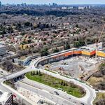
Finch Ave W LRT: Work is underway to build the Finch West LRT. The anticipated date of completion is 2023. This process will include adding protected bike lanes to Finch Ave alongside the LRT route. The LRT is 11 km long.

Complete streets process by default: When reconstructing a street, staff must consider building a Complete Street (one which works for all road users regardless of age, ability, or mode) which often includes bike lanes. We'll work closely with City Staff to ensure this process is followed.


Source: https://www.cycleto.ca/news/cycling-infrastructure-toronto-where-are-we
 
The complete streets idea is silly because the various modes will have inherently different priorities and problems.
 

Back
Top