News   Jul 15, 2024
 371     1 
News   Jul 15, 2024
 540     0 
News   Jul 15, 2024
 560     0 

West Scarborough Railpath | Conceptual

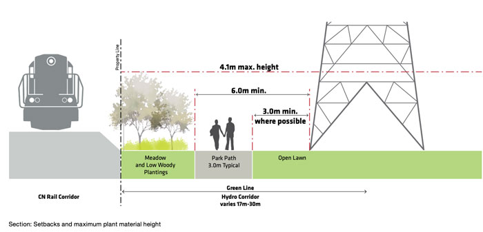
I second the sentiment that it's not precluded by rail operations. I walked this years ago before I fully flushed out my method of documentation, so pictures are sparse, but it's on my list of walks to refresh. It's noteworthy that, east of Birchmount, the hydro lines jump from south to north of the tracks, before coming back. It's also noteworthy that where it jumps north, the south side is occupied by a storage yard that's mapped as still being part of the CN right-of-way, and another city-owned strip is wedged between it and the backyards for houses on Roebuck.

View attachment 521714

Wow...great photos of your walk up this route back in 2017!

Wishful thinking. Imagine being able to connect from the Danforth cycle track along a West Scarborough Rail Path to the Meadoway and up to the Zoo. :)
 
Wow...great photos of your walk up this route back in 2017!
Heh, sometimes we ourselves are our greatest critics :)

Wishful thinking. Imagine being able to connect from the Danforth cycle track along a West Scarborough Rail Path to the Meadoway and up to the Zoo. :)
Wishful thinking because of political cynicism? It's ridiculous that the land base is all there in public ownership, (relatively) no land costs, there's just no budgetary priority fin forging the trails.
 
Heh, sometimes we ourselves are our greatest critics :)


Wishful thinking because of political cynicism? It's ridiculous that the land base is all there in public ownership, (relatively) no land costs, there's just no budgetary priority fin forging the trails.

Well.........
 
There's a multi-use path alongside the low-speed CN Waterloo Spur between Lancaster Road in Kitchener and Uptown Waterloo, which only operates in the wee hours when the LRT doesn't. There's some separation, but no fencing. For a block in Uptown Waterloo, the path and the rails share the same space (with signs telling path users to yield to trains). There is separation and fencing between the MUP and the LRT corridor (which it shares with CN spur) but those are faster and much, much, more frequent.

As long as there's room between the path and the spur and there are safe ways for pedestrians and cyclists to cross Kennedy and Birchmount, I can see it working.
 
Found two photos I took of the path that follows the Waterloo Spur:

IMG_5985.jpeg
IMG_5986.jpeg
 
There's a multi-use path alongside the low-speed CN Waterloo Spur between Lancaster Road in Kitchener and Uptown Waterloo, which only operates in the wee hours when the LRT doesn't. There's some separation, but no fencing. For a block in Uptown Waterloo, the path and the rails share the same space (with signs telling path users to yield to trains). There is separation and fencing between the MUP and the LRT corridor (which it shares with CN spur) but those are faster and much, much, more frequent.

As long as there's room between the path and the spur and there are safe ways for pedestrians and cyclists to cross Kennedy and Birchmount, I can see it working.

Found two photos I took of the path that follows the Waterloo Spur:

View attachment 522092View attachment 522093

I took some photos of that spur to uptown, as well as where it doubles as LRT track. The key here is that CN doesn't actually own that spur, the Region of Waterloo does, and CN operates it on contract. Another parallel you can draw is to the Guelph Junction Railway; owned by the City of Guelph and currently operated by Goderich and Exeter Railway.

Municipal ownership + industrial spur service seems to be the common denominator, so whether you could pull this off when CN retains the ownership makes me hesitate.
 
Taken from Councillor Kandavel's May 25 Community Newsletter (my Ward 20):

Action Needed - West Scarborough Rail Trail
We’ve been informed by City staff that the West Scarborough Rail Trail is not being recommended in the upcoming Infrastructure and Environment Committee next Tuesday, May 28th. The development of this trail is a priority for our community.
I am working to strongly advocate for this, and I encourage you to do the same by submitting comments or requesting to speak on the item, which will be coming to committee on May 28th. Go to this link for the agenda item, and click "Submit Comments" at the top of the page. Alternatively, you can email the Councillors on the committee directly.


As per his request, I did submit an email to the Committee as did several others.

With thanks to @Northern Light for this: "Of note, Councillor Kandavel spoke and got the chair to move a motion, but it was only to advance a final report on the Scarborough West Rail Trail."

1. City Council request the General Manager, Transportation Services to finalize the Scarborough West Rail Trail study undertaken as part of the 2022-2024 Cycling Network Plan Update regarding the feasibility of a multi-use trail along the former GN-GECO rail spur line, update the local Councillor on the outcome of the feasibility study, and work with the local Councillor to update the community on the feasibility study including publishing a summary of the study for the public by the end of the third quarter of 2024.


Looking at info from the meeting, I was impressed by the well written submission from Josh Matlow.
Screenshot 2024-05-29 at 8.43.27 AM.png
 
Taken from Councillor Kandavel's May 25 Community Newsletter (my Ward 20):

Action Needed - West Scarborough Rail Trail
We’ve been informed by City staff that the West Scarborough Rail Trail is not being recommended in the upcoming Infrastructure and Environment Committee next Tuesday, May 28th. The development of this trail is a priority for our community.
I am working to strongly advocate for this, and I encourage you to do the same by submitting comments or requesting to speak on the item, which will be coming to committee on May 28th. Go to this link for the agenda item, and click "Submit Comments" at the top of the page. Alternatively, you can email the Councillors on the committee directly.


As per his request, I did submit an email to the Committee as did several others.

With thanks to @Northern Light for this: "Of note, Councillor Kandavel spoke and got the chair to move a motion, but it was only to advance a final report on the Scarborough West Rail Trail."

1. City Council request the General Manager, Transportation Services to finalize the Scarborough West Rail Trail study undertaken as part of the 2022-2024 Cycling Network Plan Update regarding the feasibility of a multi-use trail along the former GN-GECO rail spur line, update the local Councillor on the outcome of the feasibility study, and work with the local Councillor to update the community on the feasibility study including publishing a summary of the study for the public by the end of the third quarter of 2024.


Looking at info from the meeting, I was impressed by the well written submission from Josh Matlow.

The issues w/this project are covered very briefly in an attachment to the 2025-2027 Cycling Plan, here:


From the above:

1716987926842.png
 
The issues w/this project are covered very briefly in an attachment to the 2025-2027 Cycling Plan, here:


From the above:

View attachment 567563
Having ridden along Taylor-Massey/st clair ravine trails quite a bit, I was curious about the significant challenges, and might as well share...

Slopes approaching st clair from the east:
Screenshot_20240529_110915.jpg


Looking west near st clair/existing trail:
Screenshot_20240529_111459.jpg


The unused bridge span for transit expansion?
Screenshot_20240529_120047.jpg

Is anyone aware of any plans for that bridge?

Lastly, the part about being close to hydro/narrow... Don't we already have this?
Screenshot_20240529_120333.jpg

Or is it a grandfathered in thing where we want to avoid?

The last image above... could we use this to mitigate issues crossing at St Clair? That is, path could follow on steet on Pidgeon St through residential, onto Warden (we're planning MUP here anyways right?) to cross at St clair/warden into existing warden woods trails?
 
Last edited:
Having ridden along Taylor-Massey/st clair ravine trails quite a bit, I was curious about the significant challenges, and might as well share...

Slopes approaching st clair from the east:
View attachment 567609

Looking west near st clair/existing trail:
View attachment 567610

The unused bridge span for transit expansion?
View attachment 567620
Is anyone aware of any plans for that bridge?

Lastly, the part about being close to hydro/narrow... Don't we already have this?
View attachment 567629

Or is it a grandfathered in thing where we want to avoid?

I'm not specifically aware of grandfathering as such; though the plans for that subdivision may well pre-date Hydro One (going back to the old Ontario Hydro) but I'm not sure.

But I suspect that would be treated differently anyway, as it would be seen as a walking path connection to the school, probably with a vehicular easement for Hydro.

But frankly that's just a guess, nothing I've looked into.

The last image above... could we use this to mitigate issues crossing at St Clair? That is, path could follow on steet on Pidgeon St through residential, onto Warden (we're planning MUP here anyways right?) to cross at St clair/warden into existing warden woods trails?

I'm not entirely sure what you're getting at here.

There is no near-term plan for cycling infra on Warden here, that I'm aware of........

****

The original intent was to cross St. Clair using the old GECO Freight Rail bridge. But the TTC has designs on that........and that appears not to be an option.

****

Its not that something can't or won't happen here at some point. Its that the challenges are high as are potential costs, for a near-term solution.

As discussed up thread, if CN (and the City) were so inclined, they could let people cross the spur on foot/bike, at-grade. That's really quite reasonable for a very low-use spur. That said, there's no guarantee of anyone agreeing to that.

The cost of getting across St. Clair (new bridge), one or more possible tunnels/bridges to have the trail switch sides of the corridor under/over the spur, getting Hydro One to waive its normal rules (or buy in whole, or in part, several homes/yards) is a lot of hassle, and financial and time risk.
 
The issues w/this project are covered very briefly in an attachment to the 2025-2027 Cycling Plan, here:


From the above:

View attachment 567563

Having ridden along Taylor-Massey/st clair ravine trails quite a bit, I was curious about the significant challenges, and might as well share...

Slopes approaching st clair from the east:
View attachment 567609

Looking west near st clair/existing trail:
View attachment 567610

The unused bridge span for transit expansion?
View attachment 567620
Is anyone aware of any plans for that bridge?

Lastly, the part about being close to hydro/narrow... Don't we already have this?
View attachment 567629
Or is it a grandfathered in thing where we want to avoid?

The last image above... could we use this to mitigate issues crossing at St Clair? That is, path could follow on steet on Pidgeon St through residential, onto Warden (we're planning MUP here anyways right?) to cross at St clair/warden into existing warden woods trails?

A couple things:

Yes, the grades are a challenge, but not insurmountable. It sounds like a scoping exercise. And @Northern Light has characterized the bridge thing well.

The 15m around the hydro towers is the required clear working zone for Hydro One crews, so no new structures, grading or furniture. It's 3 metres that the trail needs to respect. The below is from the City itself (Green Line Design Restrictions):

green-line-design-restrictions.jpg
 
I'm not entirely sure what you're getting at here.

There is no near-term plan for cycling infra on Warden here, that I'm aware of........
I realized this after I posted and striked it out... Probably before you were drafting the reply. My point was really, if crossing st clair is such an issue preventing further work effort, then perhaps, as a temporary solution to have signage to direct through residential onto warden and then to Warden woods.

Something like:
Screenshot_20240529_143014.jpg

But the TTC has designs on that.
What does this mean? Are we planning on using this or just holding onto the bridge just incase... 20 years later the bridge sits idle?
 
I realized this after I posted and striked it out... Probably before you were drafting the reply. My point was really, if crossing st clair is such an issue preventing further work effort, then perhaps, as a temporary solution to have signage to direct through residential onto warden and then to Warden woods.

Something like:
View attachment 567746

Plausible.

What does this mean? Are we planning on using this or just holding onto the bridge just incase... 20 years later the bridge sits idle?

You made me ask.............as I was sure something was up there, but didn't remember the details....

I'm told train storage track, with a target of 2029 for the work.
 

Back
Top