News   Nov 04, 2024
 480     0 
News   Nov 04, 2024
 734     4 
News   Nov 04, 2024
 918     1 

Urban Wilderness!

West Don River - double-ender

As promised, starting north of Sheppard in the early morning:

77276719.jpg
77276723.jpg


77276727.jpg
77276734.jpg


77276747.jpg
77276738.jpg


77276756.jpg
77276761.jpg


77276767.jpg
77276774.jpg


Heading north through the Hinder Property hinterland:

77276778.jpg
77276782.jpg


77276794.jpg
77276808.jpg


77276814.jpg
77276820.jpg


77276827.jpg
77276891.jpg


West, under Bathurst Street:

77276901.jpg
77276914.jpg


77276933.jpg
77276940.jpg


77276945.jpg
77276948.jpg


77276952.jpg
77276969.jpg


In behind the Toronto Jewish Community Centre:

77276957.jpg
77276989.jpg


77276992.jpg
77276998.jpg


77277002.jpg
77277013.jpg


77277020.jpg
77277047.jpg


77277057.jpg
77277073.jpg


77277063.jpg


77277080.jpg
77277086.jpg


Up through the Carscadden Greenbelt:

77277092.jpg
77277096.jpg


77277100.jpg
77277111.jpg


77277112.jpg


Entering the Hearthstone Valley Greenbelt I become momentarily estranged from the river as I negotiate a confusing network of bike trails and pathways:

77277127.jpg
77277119.jpg


77277131.jpg
77277135.jpg


77277139.jpg
77277145.jpg


More strange relics of the city's past as I emerge into the West Don Parkland; starting with an oddly-located and long-forgotton basketball court, then leading to yet another mysterious concrete ruin:

77277166.jpg
77277168.jpg


77277160.jpg
77277174.jpg


77277185.jpg
77277187.jpg


77277191.jpg
77277198.jpg


77277203.jpg
77277206.jpg


77277214.jpg
77277220.jpg


77277227.jpg
77277231.jpg


On through Finch Avenue:

77277240.jpg
77277246.jpg


77277260.jpg
77277252.jpg


77277271.jpg
77277282.jpg


77277289.jpg
77277283.jpg


Out behind Robert Hicks Drive:

77277305.jpg
77277307.jpg


77277308.jpg
77277311.jpg


77277316.jpg
77277321.jpg


One of the more imposing structures on the Don - the G. Ross Lord Dam:

77277314.jpg
77277326.jpg


77277324.jpg
77277329.jpg


77277333.jpg
77277345.jpg


77277367.jpg
77277347.jpg


77277364.jpg
77277371.jpg


And where there's a G. Ross Lord Dam, one usually finds a G. Ross Lord Reservoir:

77277348.jpg
77277353.jpg


77277357.jpg
77277363.jpg


77277375.jpg
77277377.jpg


77277382.jpg
77277407.jpg


77277390.jpg
77277392.jpg


77277397.jpg
77277412.jpg


77277416.jpg
77277420.jpg


77277423.jpg
77277432.jpg


77277426.jpg


The West Don reappears just north of Westminster Memorial Gardens in a muddy flood-plain. By the way, if you know anyone buried there, and have ever wondered where all the old flowers, candles and other such grave decorations end up, apparently they end up here. Kind of a creepy place, actually:

77277446.jpg
77277451.jpg


77277437.jpg
77277442.jpg


77277459.jpg
77277462.jpg


77277467.jpg
77277469.jpg


77277476.jpg


Over a never-ending series of bridges, through G. Ross Lord Park, for the final leg:

77277479.jpg
77277483.jpg


77277486.jpg
77277493.jpg


77277498.jpg
77277504.jpg


77277514.jpg
77277519.jpg


77277522.jpg
77277528.jpg


77277536.jpg
77277538.jpg


77277543.jpg
77277546.jpg


77277552.jpg
77277555.jpg


77277562.jpg
77277571.jpg


77277577.jpg
77277580.jpg


77277583.jpg
77277589.jpg


77277592.jpg


So here we are at Steeles Avenue, and thus ends the Toronto section of the West Don River.


..or does it?


As I walk east along Steeles to Bathurst, just before Carnival Court I notice another one of those Don Watershed signs reading "West Don River."
But wait a minute! I just left the West Don...didn't I? Well, we'll see about that... I head down and find another stream emerging at Fisherville Road, which I follow south through Hidden Trail Park:

77277596.jpg
77277605.jpg


77277606.jpg
77277609.jpg


77277614.jpg
77277618.jpg


77277623.jpg
77277625.jpg


77277628.jpg
77277633.jpg


77277637.jpg
77277644.jpg


Past another bridge and I end up back in G. Ross Lord Park, where the stream meets up the West Don - or is that vice versa?:

77277645.jpg
77277649.jpg


77277651.jpg
77277654.jpg


77277663.jpg
77277472.jpg


Back home I consult the Vaughan section of my MapArt street map and see that the second stream could be a continuation of the Westminster Creek - though things get a little hazy around Loma Vista Drive.
Anyone out there that could shed some light on the situation?
 
Last edited:
Haha, nope! I figure they call it Baneberry for a reason.


PS
I also thought I might have located a patch of amanita mushrooms near there.
I considered "touching" them, but thought better of it...
 
Last edited:
Haha, nope! I figure they call it Baneberry for a reason.


PS
I also thought I might have located a patch of amanita mushrooms near there.
I considered "touching" them, but thought better of it...

With some of the recent events in the news, I hope you never come across any of what has been found.
 
G Ross Lord is truly a reminder of how aggressively utilitarian such public works got by the 70s--urban infrastructure for an era when basic jeans-and-t-shirt passed for high school fashion...
 
Figures-I'm out of town, and we get to my old stomping grounds on the West Don.

The area known as the Hinder property was named after the Hinder family. Originally it was called Chuckle Hollow, after the laugh William MacKenzie had when evading government troops during his flight after the 1837 rebellion. After Montgomery's tavern was burned, MacKenzie fled up Yonge St, taking shelter with the Shepard family (as in today's Sheppard ave) He then fled westwards, along the property that is today's York Cemetery. The troops thought he would be trapped by the steep sides of the hollow, but a friend with a rope and a horse was able to get MacKenzie up the cliff face and away.

The basketball courts-could they be an abandoned part of the Forest Valley Outdoor Ed centre?

As for the concrete ruin, I'd guess it was a structure destroyed by Hazel. Unfortunately the 1954 aerial photos at McMaster University aren't clear enough to show anything around here

http://library.mcmaster.ca/maps/airphotos/zoom/1954-1955_437792.htm
 
I second that.

Thank you for another enjoyable series. One of these days, I'd like to get out and see some of this in person.

Yeah, I just saw that on the news this morning. They where saying they found the body parts in some tied-up plastic bags, which is quite a common sight out in the ravines. I've never been the type to go poking around in discarded bags though - even less so now!

Apparently last month, on my previous trip to the West Don, I went past the spot where they found another body at the Don Valley Golf Course earlier this year...
 
G Ross Lord is truly a reminder of how aggressively utilitarian such public works got by the 70s--urban infrastructure for an era when basic jeans-and-t-shirt passed for high school fashion...

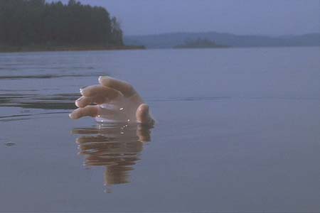
Speaking of bodies and dams and the 70s, it's interesting to note that construction on the dam started right around the time Deliverance came out (1972).
Makes one wonder what might be at the bottom of that reservoir...

deliveranc.jpg
 
Figures-I'm out of town, and we get to my old stomping grounds on the West Don.

The area known as the Hinder property was named after the Hinder family. Originally it was called Chuckle Hollow, after the laugh William MacKenzie had when evading government troops during his flight after the 1837 rebellion. After Montgomery's tavern was burned, MacKenzie fled up Yonge St, taking shelter with the Shepard family (as in today's Sheppard ave) He then fled westwards, along the property that is today's York Cemetery. The troops thought he would be trapped by the steep sides of the hollow, but a friend with a rope and a horse was able to get MacKenzie up the cliff face and away.

The basketball courts-could they be an abandoned part of the Forest Valley Outdoor Ed centre?

As for the concrete ruin, I'd guess it was a structure destroyed by Hazel. Unfortunately the 1954 aerial photos at McMaster University aren't clear enough to show anything around here

http://library.mcmaster.ca/maps/airphotos/zoom/1954-1955_437792.htm

Fascinating bit of history HTH - thanks!

As for the courts, that did cross my mind - however they're on the opposite side of the river from where the FVOEC is today; unless it straddles both sides of the Don?

The concrete ruins were somewhere between the Forest Valley Centre and St. Bernard's on the west bank, while the basketball courts were just a little south of them, on the east bank. I wondered if perhaps they were related to the apartments on Goldfinch Court?
 
Fascinating bit of history HTH - thanks!

As for the courts, that did cross my mind - however they're on the opposite side of the river from where the FVOEC is today; unless it straddles both sides of the Don?

The concrete ruins were somewhere between the Forest Valley Centre and St. Bernard's on the west bank, while the basketball courts were just a little south of them, on the east bank. I wondered if perhaps they were related to the apartments on Goldfinch Court?

I'm not certain as to the exact boundaries of the FVOEC. Back in the 80s and 90s when I was a kid and I'd visit the Forest Valley, depending on the school trip we'd hike anywhere between Finch and the flood control structure on the north side of the Koffler gallery/Jewish Community centre.

Some of the historical images on Google Earth were taken when the trees were bare, would you be able to find the courts and the ruins on those images?
 
Still inconclusive - but judging from the McMaster map I'd say there could be a lot more hidden away out there:

26976149.jpg


There seems to have been a lot more open/cleared space back then, especially along the river banks.
 

Back
Top