News   Jul 26, 2024
 88     0 
News   Jul 25, 2024
 821     0 
News   Jul 25, 2024
 713     0 

Updates to PATH

I don't know when you last looked at the map
Those items weren't there a few days ago. The opening of the Ryerson Business Building must have triggered an update.
 
This thread has been silent for a long time but I was wondering if anyone has curent suggestions about dersirable PATH extensions or improvements.
 
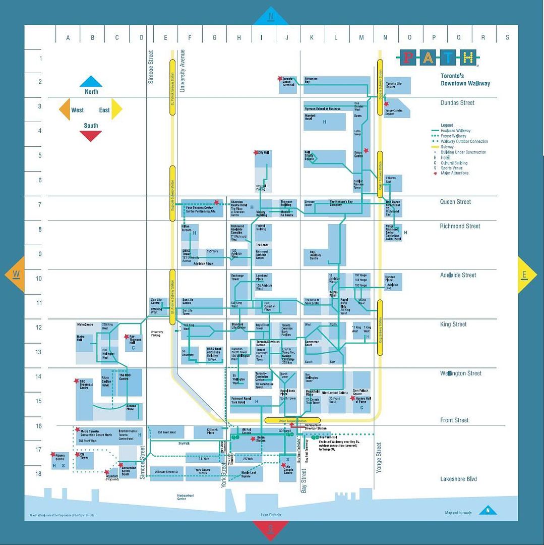
Let's start by showing everyone where PATH is right now...

http://www.toronto.ca/path/pdf/path_brochure.pdf

Perhaps someone else can lift the image (page 2 of the brochure) out and post it.

***

It shows the many updates to that Path since '06 when this thread as last active; and is current to the end of 2010, give or take 'Toronto Life Square' :D

New to the PATH in recent years (among others):

- The aforementioned 10 Dundas East
- RBC Dexia
- Bay Adelaide Centre

***

As for gaps, the 'proposed connections' in the above map (link) show a pretty comprehensive list of what's do-able.

I'm fascinated by the fact, as far as I know, that Four Seasons to Sheraton connection is not complete, even though that facility is now almost 2 years old (anyone correct me if I'm wrong)

I assume Ritz-Carlton's connection will open w/the hotel.

York Street will be built starting this year, I believe.

The connections south of Union haven't been made yet, I don't think (again corrections welcome) Can I go underground from MLS to ACC to Union yet?

I see the connections are planned to go all the way to Simcoe!.

***

Missing links within in the Dundas to Lakeshore corridor not identified....?

Few that seem easily fixable.

There's an obvious gap East to West between Richmond Adelaide and Bay-Adelaide; but I'm not sure there's any feasible way to draw that line though the foundations of older buildings.

Once the Hilton and Four Seasons are connected, they'll be a continuous path from Queen to Adelaide, parallel to University, that will need one more block (Adelaide to King) in order to make it all the way to Wellington. Its my recollection that that is the Dominion Insurance tower, older building....could use replacing.

***

Finally there's northerly growth. There is the long spoken of opportunity to weave through Ryserson, north to Aura and College Park and link in Delta Chelsea. Redevelopment of World's Biggest Bookstore would also permit a straight connection to same via the Atrium.

I should add I want A WBB to stay; but have no particular attachment to the current building.

Something else I would like to see though is a fluid connection though Hospital Row from Queen's Park Station all the way south.

There are service (patient-moving) tunnels in place to some degree now; but a serviceable mini-Path could include Mars, and run south to Elm via TGH and Sick Kids (with side connections to Princess Marg., Mt. Sinai and Toronto Rehab.

The question would then be, is there any feasible connection between there are the main Path?

Answering my own question; I'm thinking a connection from Sick Kids to its new Research bldg on Bay, then its a small jump to either Atrium or the current Bus Terminal site.
 
.

The connections south of Union haven't been made yet, I don't think (again corrections welcome) Can I go underground from MLS to ACC to Union yet?

Curiously enough, the way to do that is *overground*, in a retro-+15 way via the illuminated bridge to ACC, and then convolutedly downstairs to a series of fire doors opening onto the concourse on the north side of the ACC. Which, right now, must qualify as the "worst PATH connection ever", at least from a rational-circulation standpoint...
 
Map here:

ScreenShot063.jpg
 
Last edited:
This thread has been silent for a long time but I was wondering if anyone has curent suggestions about dersirable PATH extensions or improvements.

An indoor or covered connection to the CN Tower & Ripley's Aquarium seems an obvious improvement. For the life of me I can't picture the current connection to the CN Tower.
 
The current Skywalk goes to the Ripley's site. A covered connection to the CN Tower would be convenient, but going to the Skydome would be even better. It would have to be wide enough to handle a post game crowd going back to Union.
 
I work in the HSBC building, and we were told last fall that, as part of the agreement for HSBC to sign back up on a long term lease, Brookfield would be building a PATH connection below York to CP Tower. No timeline that I know of.
 
I work in the HSBC building, and we were told last fall that, as part of the agreement for HSBC to sign back up on a long term lease, Brookfield would be building a PATH connection below York to CP Tower. No timeline that I know of.

I think this is part of the City's plan to build a new PATH branch up York Street from the west end of Union Station - this is supposed to be done by 2014-15. Several buildings along the route will be joined to it. See: http://www.toronto.ca/union_station/path_connection.htm
 
The current Skywalk goes to the Ripley's site. A covered connection to the CN Tower would be convenient, but going to the Skydome would be even better. It would have to be wide enough to handle a post game crowd going back to Union.

Since SkyDome was built it has been a headscratcher to me.....build an all-weather stadium just west of major transportation hub.......think "we need to build an all-weather walkway to get them from transportation hub to all-weather stadium"......lets stop the the all-weather walkway just short of said all-weather stadium"......there must have been a good reason (likely it has one of these involved "$") but it just seems daft!
 
Something else I would like to see though is a fluid connection though Hospital Row from Queen's Park Station all the way south.

There are service (patient-moving) tunnels in place to some degree now; but a serviceable mini-Path could include Mars, and run south to Elm via TGH and Sick Kids (with side connections to Princess Marg., Mt. Sinai and Toronto Rehab.

The question would then be, is there any feasible connection between there are the main Path?

Answering my own question; I'm thinking a connection from Sick Kids to its new Research bldg on Bay, then its a small jump to either Atrium or the current Bus Terminal site.

MaRS II connects (or is supposed to connect) directly to Queen's Park station; that project will hopefully restart soon. MaRS connects to TGH in a publicly accessible way. I believe the connection to SickKids from THG is not card-controlled, but it certainly isn't pretty as it goes through service tunnels. Likewise, the tunnel from SickKids to Sinai and PMH. Within SickKids, the tunnels from the main building to the McMaster builiding (which is beside the new SickKids Research bldg) are by card access only.

I agree that it would be nice to be able to walk to the hospitals from Atrium on Bay or Queen's Park subway. There may be security/public health issues, though.
 
Does anyone know why Simcoe Place doesn't connect directly to the convention centre? It seems silly that the only way to connect to path from the Convention Centre is through the South wing and via the skywalk.

A
 
Does anyone know why Simcoe Place doesn't connect directly to the convention centre? It seems silly that the only way to connect to path from the Convention Centre is through the South wing and via the skywalk. A

The usual reason is $$$ but sometimes there are 'physical barriers' like a large sewer or the subway. I agree that a Simcoe Place (or CBC) link to the Convention Centre would be a great addition.
 
Just wanted to add a Thank You to Mongo for posting the map.
 

Back
Top