News   Jan 15, 2025
 360     0 
News   Jan 15, 2025
 754     1 
News   Jan 15, 2025
 492     0 

Transit Fantasy Maps

The question is how many potential St Clair-style avenues are there? Not much: in Toronto, there's only Wilson, Lawrence East, Kingston Road (into Durham Region) are major ones (which are my choices for new light rail in Toronto, as shown on my map).

Yet another question would whether or not St. Clair style avenues are truly required to transform the habits of suburbanites. Compare St. Clair and Don Mills. Both are moderate density corridors, in one case due to overall compact development, in the other due to localized apartment clusters. Both are heavily used transit and retail corridors, though in one case you tend to see street fronting retail, and in the other you tend to see localized strip malls. Although the feel is very different, both corridors see heavy transit usage by local residents for both work and shopping.

I think that in the interim, we'll do just fine if most suburban avenues tend to resemble Don Mills. The modal split and population density is on average not much different from a more urban street like St. Clair, and in all honesty, the Don Mills (between Finch and Sheppard) style development is easier to achieve in the suburbs and more naturally occurring.
 
Time to start off the work week with a bang... :cool:

TTC2075-1.jpg


This is the sequel to my last fantasy map, posted on May 12th.

Key additions/modifications


  • The DRL is extended on both ends terminating at Steeles Avenue.
  • DRL West follows the Weston-Galt to have a stop at Jane St (which is why we can skip such a stop along Eglinton) and in the dense Weston community, running as far north as Oak Street before passing just south of the Weston/401 interchange to merge with Albion Rd. Continues northwesterly along Albion Rd until it reaches the Albion Centre, to then veer north along Kipling Ave along a dense apartment building-lined stretch to Steeles. (Future extension into downtown Woodbridge a strong possibility).
  • DRL East continues north following Don Mills Road with roughly 850 metre apart spacing til the 401. To properly interface with Don Mills (Fairview) Station on the purple line, this subway veers east to allot easy level down transfers between the two subways. To save on expense and travel time, the subway effectively becomes a commuter line henceforth parallelling the 404 with only one stop between Sheppard and Steeles which directly serves Seneca College Newham Campus as well direct transfer onto the Finch Hydro Corridor busway with branches serving Finch proper and McNicoll respectively. (Future extension to Buttonville Airport a likelihood).

    Bloor-Danforth extended one stop west of Sherway Gardens to Dixie-Dundas Stn. Although this is a fantasy map, I still don't see the need to extend the Bloor Line any further west than this. Dundas BRT would be more than adequate.

    Sheppard West extension
  • I do feel that the purple line should interface directly wih YUS, but not to run upto York U. After Finch West Stn the line runs directly under Finch Avenue across to Jane-Finch. Because of the busway, this is a good place to cap it off although a subway with 2-km apart spacing could continue westwards from here with further stops at Weston, Islington, Kipling, Westmore, Humber College, Humberwood and Westwood Mall.

    YUS extensions
  • Yes by the year 2075, a subway to Richmond Hill Centre is finally needed, and not a decade before that... j/k :p
    I do cut back on the number of intermediate stops though as parallel bus traffic will always exist along this stretch of Yonge. Also vanquished from memory, that $177 million 407 Transitway Stn on TYSSE. Building a private bus-only road for BRT to directly run into VMC is better.

    Eglinton Crosstown extended in both directions, east to University of Toronto Scarborough and west to Mississauga City Centre
  • Eglinton East, 4 stop extension basically rounds off the densest section of Scarborough which would still be underserved by metro by this timeframe. Pickering commuters now have real alternative to GO Transit for entering and getting around Toronto. Bus commutes along Morningside slashed in half.
  • Eglinton West, with the Mississauga Transitway feeding directly into Highway 27 Stn; the need to directly serve Airport Corporate Centre with a subway diminishes. So instead west from Terminal 1, the line proceeds underground through the Infields to eventually surface just south of Britannia in the Etobicoke Creek watershed, crossing the 401 at a diagonal and running elevated over mainly industrial parks until Aimco/Dixie. This is the best alignment I could think of as not to interfere with planes and get the line running back towards Eglinton in Mississauga. The line then parallels Eglinton above grade til west of the 403. A shallow tunnel then completes the 2 kilometre journey to CCTT with direct underground access to Square One shopping centre. Per this fantasy the Hurontario LRT (red) runs in a straight line from Lakeshore to Bovaird with no need to divert into SQ1 as customers could transfer onto the train at Eglinton to complete their commute.
  • Little known fact, the Eglinton Line would actually have branched services: one from PIA-UTSC, the other MCC-OSC via the DRL. The key with the Mississauga branch is to eliminate a transfer for customers heading to/from downtown Toronto. As such this express branch would run local from SQ1 to Higwhay 27 then skip all the stops until Mt Dennis via quad-tracking of the Richview ROW. Hopefully such a move would result in 40 minute commutes between SQ1 and the CBD with customers being able to get off anywhere in-between throughout the downtown core.

    Queen Street Subway!!
  • Yes, even after the DRL I still see the need for a east-west line right across the southern edge of the 416. As you can see, the orange line shares the central ROW with the DRL; serving a majority of the same stops. However as not to duplicate service while other parts of the downtown could use better service, I revisited an old proposal of mine that routes the DRL directly though the downtown, cross-cutting through major intersections. This time though instead of continuing north from Ossington/Dundas (Rua Acores), the Queen Line re-emerges with the DRL at Dufferin and continues straight ahead to serve Swansea and Mimico. Beyond Mimico/Lakeshore there's not enough density to support a metro, so busways take over from there (running directly all the way into downtown Oakville).
  • Queen East. The 501 car is no more and the subway continues east rom the Carlaw interchange to directly serve the Beaches community before veering north deep underground through the hilly interior to Bingham Loop on the Scarborough border. From here the Kingston Rd busway takes over.

    Busways
  • I modified the Wilson Crosstown BRT in light of the new DRL West extension to now short-turn after Elmhurst Stn into the Cherrywood Hydro Corridor running south to directly serve Etobicoke North GO Stn and the Toronto Congress Centre before terminating at Highway 27 Stn.
  • You'll also notice a whole slew of new BRT routes entering Mississauga, Brampton and Pickering. (more on those later).

So disappointing to realize that I'll be long dead before even a third of this gets built. Oh well, to dream a dream.
 
Or better yet, extend a Vic Park leg to Steeles, meeting DRL?

*I'd prefer Queen line to follow Queen st. rather than trying to reach every neighbourhood in T.O. And extend Eglinton to Pickering TC.
 
Last edited:
That is amongst the better maps I have ever seen. Someone finally sees the benefits and transfer/cost savings of interlining.
I agree that extending Victoria South station to the BD line would be essential and relatively inexpensive. Refreshing to see someone also learning from the ret of the planet and using current rail ROW.
The only major thing I would suggest , and it would save a small fortune to boot, is interline the the two downtown lines into one and under Queen NOT King. Not only do I think Queen would be more useful for most Torontonians but also tunneling uder King would cost a king's ransom. Remember under King you have the largest and most complex network of the PATH system. The stations would have to be so deep you could see China.
Also that small business area of King already has 3 subway stations including the busiest transit centre in the whole country, Union.
Still a very well thought out system and very doable even with limited funds.
 
Interlining of subway lines is great, but to really make a difference, each line should retain its two tracks to enable an express/local system to be implemented. On the latest fantasy map, the orange line could stop everywhere, whereas the DRL would stop only at Broadview, Parliament, and Union. There is no sense having two subway routes stop at minor stations when only one would suffice.
 
Thanks for the suggestions. Here's how I modified things:

2075.jpg


I thought about it and yes it does make a lot of sense to link the Queen Line to Bloor-Danforth. Per this alignment passengers starting at Scarborough City Centre now have the option to choose whether they want south central 416 (B-D) or southern 416 (Queen Inner-city) as their preferred route. All the stops between SCC and VP would be accessible to both lines (by this timeframe automated annoucements and LCD display along the whole platform will indicate to customers which train route is arriving). At Pharmacy two side-tracks (EB and WB) splinter off from the main trackbed and dive underground for a shallow station just beneath the mezzanine level of the existing stop. This platform would be at a diagonal as to easily merge down Victoria Park Avenue. At Musgrave, in-between the Lakeshore corridor and Gerrard St, the next station would allow easy transfer to the 135 bus and a relocated Danforth GO Stn. Also easy walking distance of shops on the Danforth. Nothing else really changes besides station names (I like Fallingbrook as a stop name even if its a misnomer). Gerrard Stn on the DRL line also becomes Riverdale and River Stn becomes West Don Lands as to avoid confusion.

Chuck I hear what you're saying, but given that the customer base for both lines is stemming from different areas of the city, it only makes sense to have each train serve each stop as to avoid unnecessary backtracking and transfers. The thinking here is to allow 1 minute headways through the central ROW during peak hours. Plus every station en route is well worth the stopover too given the projected density that'd be surrounding each.
 
Honestly your Queen Line is just completely ridiculous. If you're gonna do a Queen Line, it should be as far from the DRL as possible. And it should run along, you know, QUEEN STREET. Therefore if you want both, you need to push the DRL further south to the rail alignment and right through Union Station. Other than that, the map looks pretty good.
 
I'd strongly recommend adding Eglinton extension to Pickering. Followed by Finch extension to Humber College. Maybe Sheppard can extend to UTSC, connecting Eglinton as well...
 
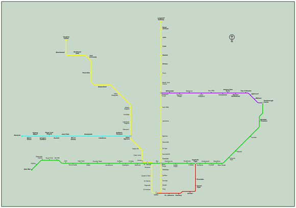
Seeing all Transit proposal from the mayoral candidates, and the proposal from SOS, I offer my own proposal, as yet another alternative, with cost competitive to Transit City (for City of Toronto only).


Obviously I made this map by hastily hacking the other map I had made earlier. Other is basically the ultimate plan and what you see here is like the first step or phase 1.

Just focus on fixing the most pressing issues for Toronto transit right now, such the pointless transfers and isolation of SCC, or the large amount of MT buses along Dundas and Highway 427, or the lack of alternatives to the downtown subway and streetcar lines that have all reached their limits. Just focus on the most important things.
 
Last edited:
Seeing all Transit proposal from the mayoral candidates, and the proposal from SOS, I offer my own proposal, as yet another alternative, with cost competitive to Transit City (for City of Toronto only).


Obviously I made this map by hastily hacking the other map I had made earlier. Other is basically the ultimate plan and what you see here is like the first step or phase 1.

Just focus on fixing the most pressing issues for Toronto transit right now, such the pointless transfers and isolation of SCC, or the large amount of MT buses along Dundas and Highway 427, or the lack of alternatives to the downtown subway and streetcar lines that have all reached their limits. Just focus on the most important things.

For the Sheppard Line, Bridlewood, is more Finch and Warden-ish; I'm in the area and it's not something locals would agree with. Just sayin'. Other than that, good map.
 
I agree with your map Doady. Except I think Eglinton should hit Yonge. But I know your proposal is not your ultimate plan so I get why you did it.
 
Anything for a possible (no LRT on St Clair Ave W. or Subway service directly underneath existing LRT) St. Clair subway?

Can't mod maps, but if anybody could point out a possible straight route as west as Jane to a bit past Yonge (Beyond St. Clair station)?
 

Back
Top