News   Nov 28, 2024
 161     0 
News   Nov 28, 2024
 328     1 
News   Nov 27, 2024
 1.1K     4 

Transit Fantasy Maps

Had an inspiration while reading some of the transit threads and in light of recent discussion.

Bloor Line extended to Dixie GO. Exits the rail corridor before Shorncliffe to return to Dundas corridor. It could remain on the rail corridor, but I figure there is more development potential off the corridor than on it.

The Relief Line on the other hand, loops down to Humber Bay, meets Park Lawn GO, and rises back to The Queensway to Sherway Gardens. At Sherway, it heads up West Mall to Rathburn, then cuts through the park to Renforth up to the airport.

1546840939379.png


I was never a fan of repeating service along the Kitchener Corridor with traditional Relief Line West routes. This alignment brings rapid transit to a lot of Etobicoke that is under-served currently.
 
That RL alignment is interesting... In fact I really like it if we absolutely must take the line west. My only caveat is that I really think that we'd be better off with light rail out there, probably as a waterfront branch on the Queensway and a seperate standard guage line integrated with Eglinton from Long Branhc up to the Airport and onto the Finch Extension. My inclination for some time has been that the best all around option RL West is actually to just stop no further west than Roncessvalles and possibly as far east as the Ex.

Also gotta add that I really like the idea that came up in some thread recently of a Milton corridor Tram-Train from the Hurontario LRT loop to Union. Assuming the upgrades for all day two way of some sort happen anyway this has all the benefits of a BD extension with very low costs. Even adding a small diversion loop to get the trains to Sherway would be massively cheaper than any option involving the subway or diverting the primary GO service through Square One (which has showed up on Metrolinx long term concept stuff a couple times).
 
Had an inspiration while reading some of the transit threads and in light of recent discussion.

Bloor Line extended to Dixie GO. Exits the rail corridor before Shorncliffe to return to Dundas corridor. It could remain on the rail corridor, but I figure there is more development potential off the corridor than on it.

The Relief Line on the other hand, loops down to Humber Bay, meets Park Lawn GO, and rises back to The Queensway to Sherway Gardens. At Sherway, it heads up West Mall to Rathburn, then cuts through the park to Renforth up to the airport.

View attachment 170103

I was never a fan of repeating service along the Kitchener Corridor with traditional Relief Line West routes. This alignment brings rapid transit to a lot of Etobicoke that is under-served currently.
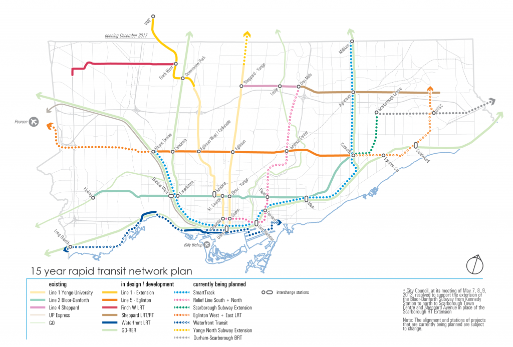
Just grade separate the Eglinton West LRT and you have a subway to Toronto that intersects the UPE and the Yonge line twice. That's the easiest way to get a subway to the airport.
(and likely a branch along the transitway is the easiest way to get a subway to SQ1).

8dbb-Network_map_web-01-1024x693.png

I was interested as an exercise in seeing how we can bring rapid transit service to Markland Woods, Burnhamthorpe, Rathburn, and Eringate/Renforth, while maximizing development potential (and thus supporting expansion of housing supply) along The West Mall corridor. I believe there is a lot of infill potential surrounding Hwy-427.

At that point, it is silly to not extend the line all the way to the airport. Have the Feds pay for it even.

That RL alignment is interesting... In fact I really like it if we absolutely must take the line west. My only caveat is that I really think that we'd be better off with light rail out there, probably as a waterfront branch on the Queensway and a seperate standard guage line integrated with Eglinton from Long Branhc up to the Airport and onto the Finch Extension. My inclination for some time has been that the best all around option RL West is actually to just stop no further west than Roncessvalles and possibly as far east as the Ex.

Also gotta add that I really like the idea that came up in some thread recently of a Milton corridor Tram-Train from the Hurontario LRT loop to Union. Assuming the upgrades for all day two way of some sort happen anyway this has all the benefits of a BD extension with very low costs. Even adding a small diversion loop to get the trains to Sherway would be massively cheaper than any option involving the subway or diverting the primary GO service through Square One (which has showed up on Metrolinx long term concept stuff a couple times).

Possibly. I'm not married to the technology. For the short-term, I definitely fall in the camp that Sunnyside is a natural western terminus for the Relief Line West, but that is based on a potentially unrealized hope that Waterfront West LRT and Queensway LRT are also eventually built (and connected to a transit hub at Sunnyside), to which I have become very skeptical of it ever being realized.

It is also a matter of city building for me, as I described to BurlOak above. I see The Queensway as an ideal corridor for Toronto to place a lot of it's growth onto. A subway on Queensway would allow the type of density I am envisioning for the corridor (10 storey fronting Queensway, rising to 40s adjacent to the Gardiner, stretching from Sherway Gardens all the way to Royal York).

Then there is the matter of adequately servicing Humber Bay Shores. I made this map some time ago but I will repost because it is an my opinion an interesting alignment/stop-spacing proposition.

HumberBayDRL.png


I think a subway with the above alignment removes the question of Lakeshore LRT vs. Queensway LRT. You can reach both with the right subway alignment.
 
I was interested as an exercise in seeing how we can bring rapid transit service to Markland Woods, Burnhamthorpe, Rathburn, and Eringate/Renforth, while maximizing development potential (and thus supporting expansion of housing supply) along The West Mall corridor. I believe there is a lot of infill potential surrounding Hwy-427.

At that point, it is silly to not extend the line all the way to the airport. Have the Feds pay for it even.


Possibly. I'm not married to the technology. For the short-term, I definitely fall in the camp that Sunnyside is a natural western terminus for the Relief Line West, but that is based on a potentially unrealized hope that Waterfront West LRT and Queensway LRT are also eventually built (and connected to a transit hub at Sunnyside), to which I have become very skeptical of it ever being realized.

It is also a matter of city building for me, as I described to BurlOak above. I see The Queensway as an ideal corridor for Toronto to place a lot of it's growth onto. A subway on Queensway would allow the type of density I am envisioning for the corridor (10 storey fronting Queensway, rising to 40s adjacent to the Gardiner, stretching from Sherway Gardens all the way to Royal York).

Then there is the matter of adequately servicing Humber Bay Shores. I made this map some time ago but I will repost because it is an my opinion an interesting alignment/stop-spacing proposition.

View attachment 170150

I think a subway with the above alignment removes the question of Lakeshore LRT vs. Queensway LRT. You can reach both with the right subway alignment.

Agree entirely about the Queensway in Etobicoke needing to be focussed on a LOT more.

If it's a subway I'd say that alignment is nigh on obvious. If we're talking light rail I'd maintain the existing Queensway ROW though, and suggest that a surface route via Park Lawn to get back to the Queensway is sufficient if the Queensway service DOES have to dop south, but would actually suggest that a more direct route straight across the Queensway never going south of Humber Loop is more reasonable if we're going to run this as light rail, though I do see the appeal of branching the service where it can increase frequency to the condos. I almost think the idea would be to build a triangular on street loop and replace Humber entirely...

Triangle.png


In combination with waterfront I do think light rail is what I think is more suitable in Etobicoke; bear in mind it WILL intercept the DRL, while also running direct to Union, I don't support the Queensway being a branch of the Queen Car or having either a forced transfer or no direct subway connectivity before Line 1. 10 storey continuous on Queensway seems a bit ambitious to me (both practically, unless we're only talking in terms of individual residential towers, and politically), but I'd argue even that could be served by proper light rail, though getting two or three car trains into Union is a problem even with the most extensive rebuilds discussed. Even cost aside, I feel like this is going to build a better urban form on Queensway and is less likely to seriously compromise the Lakeshore service.
 

Attachments

  • Triangle.png
    Triangle.png
    2.2 MB · Views: 400
Had an inspiration while reading some of the transit threads and in light of recent discussion.

Bloor Line extended to Dixie GO. Exits the rail corridor before Shorncliffe to return to Dundas corridor. It could remain on the rail corridor, but I figure there is more development potential off the corridor than on it.

The Relief Line on the other hand, loops down to Humber Bay, meets Park Lawn GO, and rises back to The Queensway to Sherway Gardens. At Sherway, it heads up West Mall to Rathburn, then cuts through the park to Renforth up to the airport.

View attachment 170103

I was never a fan of repeating service along the Kitchener Corridor with traditional Relief Line West routes. This alignment brings rapid transit to a lot of Etobicoke that is under-served currently.

If you're going to do that, you would be better off turning the 427 into the Toronto version of the Dan Ryan (moreso than Allen Rd already is). Not only would it be significantly less expensive, but you have development occurring on both sides of the 427, so the catchment area going down the middle would be greater than if you had it only under the one side.

Interesting thought though.
I thought about it, but I wonder how accessible stations under the 427 would actually be to East Mall and West Mall. I guess I just need to see how it could be done.
 
I thought about it, but I wonder how accessible stations under the 427 would actually be to East Mall and West Mall. I guess I just need to see how it could be done.

You could use the road overpass as one of the entrances, and then build a pedestrian-only overpass at either the south or north end of the platform (depending on how the platform was situated relative to the overpass) to provide additional connectivity.

I realize it's not ideal, but the walk shouldn't be too bad.
 
Would there have been any room to put a moving walkway in/on the pedestrian bridge? It seems like a long distance to walk.

Would it be much longer than the walk between the VIVA/GO terminal and the subway platform at Finch? I would think it would be in the same ballpark.
 
I was looking at Kitchener GO and was thinking what would adequately serve a city like Kitchener? I decided 4 stations would do.

Ideally, with fare-by-distance so that commuting from Kitchener West to Kitchener Centre would be like $3 bucks or something.

Kitchener GO.png


Is 4 stations excessive in the long-run? Discuss away.
 
Posted that excessive? No, probably not tbh. I'd move Grand River to Breslau, rather than an additional station though. I'd also think about taking the service west to Baden/New Hamburg and dropping Westmount.
 
Posted that excessive? No, probably not tbh. I'd move Grand River to Breslau, rather than an additional station though. I'd also think about taking the service west to Baden/New Hamburg and dropping Westmount.
I based stations on catchment area. Breslau makes sense stop-spacing wise, but a station located where I had placed it better serves the subdivisions west of Grand River, while a station at Breslau is not well connected to those areas at all. Also more (high-intensive) development potential surrounding Victoria Street and Lackner Blvd than in Breslau.

A station at Westmount relieves pressure at Kitchener GO and serves that whole Westmount catchment area. I figured that Kitchener being more or less at the end of the line, it doesn't matter so much to have too many stations because you aren't delaying commuters further down a line. But yes, this was the most 'excessive' addition to the map.

I'm supportive of extending to Baden/New Hamburg, perhaps a terminus all the way out at Stratford even. I just ran out of room on my map. :p
 
I was looking at Kitchener GO and was thinking what would adequately serve a city like Kitchener? I decided 4 stations would do.

Ideally, with fare-by-distance so that commuting from Kitchener West to Kitchener Centre would be like $3 bucks or something.

View attachment 170725

Is 4 stations excessive in the long-run? Discuss away.

I would rename Kitchener West to The Boardwalk. It's actually a great spot for a go station in my eyes because there's a giant parking lot, quite a significant amount of development, and a bus terminal all at that location. I'm just not sure if the people of Westvale would appreciate trains going by every half hour to Guelph or every 2 hrs to Toronto.
 

Back
Top