News   Jul 15, 2024
 480     3 
News   Jul 15, 2024
 636     0 
News   Jul 15, 2024
 578     0 

Transit Fantasy Maps

With all of the ideas for transit lines, if all were built, what would the city look like? I am not just talking the lines themselves, I mean the entire cityscape. What would Toronto look like with real transit?

Not too different from today I reckon. It can take decades for land uses to catch up with transit lines and much of the suburbs would have already been built as sprawl prior to those lines, if those lines were even built.

The trend to build downtown would still happen, development of the raillands and the waterfront would still be happening, STC and other regional sub-centres will still be failures.

Important to note too that it is not like that the large sum of Toronto is a transit desert. It might not be rapid transit, but all those suburban arterials contain very frequent, well-used bus routes with more than decent ridership levels. Transit already does exist, it is just bus rather than LRT or subway.

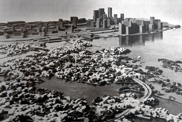
Well for one, that map shows "Proposed Island development" aka Harbour city, which would have had a huge impact on the city if it were built:
20140122-Mega-Harbour.jpg


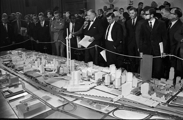
It also shows the "Proposed CN/CR development" aka Metro Center
20140122-Mega-Metro.jpg


In general, the worst GTA sprawl happened in the 1990s and 2000s, so having all that transit in place in the 70s would have helped compactify the GTA greatly and probably shift a lot of development to the 416 from the 905. The "City Centers" planning concept still wouldn't have been everything it was meant to be, but it would have been much more successful and you would see less office-park style development. In general, the built form of the GTA would be improved greatly and transit mode share would be a lot higher.

Toronto would be a much more interesting place to visit with it's own floating neighbourhood downtown and with Metro Centre the CN/CP lands would have become a new South Core instead of staying as parking lots for decades.
 
Hey, I was wondering what do you think of my map?

Love line 3 to Bluffers. Could have been a game changer for the LRT as seamless North-South line that connected one of the most integral locations in Toronto's Waterfront as a tourist destination and transformed parts of that Kingston rd/"waterfront" area into an attractive urbanised node. Not a fan of leaving Sheppard as an Elephant trunk but love the overall vison and attention to key details. As others mentioned use the appropriate thread to post it for further discussion. Thanks for sharing

No. The most significant political commitment it's gotten recently was a motion passed on Council, and supported by Tory, to explore feasibility of extending the line at some point after 2031. Obviously a motion that was designed to be a completely inconsequential gesture.

Compare this to Crosstown West, Crosstown East, Relief Line Short and Waterfront transit, all of whom all rapidly progressing, and should be fully funded if the provincial government matches the federal infrastructure grant from several months ago (Should be about $12.5 Billion funding in total).

Yonge North and Relief Line Long, while unfunded, have had the political and financial support to rapidly push those two projects beyond the planning phases.

Agreed. Sheppard will either be Politically forced into the DRL long/Richmond Hill extension bundle or be held outside until after those lines are solidified. The last 10 years foreshadow that pushing it out may be a costly mistake if Politicians choose to play into it. This time it wont only be Scarborough voters to gain so I don't believe it will stay silent as it is today. Tory basically acknowledged it as a thing and will be continually nudging the ball toward the Mayor in 2022 to juggle
 
Last edited:
Here is my map guys. I have a newer version including Etobicoke RT.

Does it go to Malvern Town Centre or just Markham/Milner? My only suggestion to bump a line up thru MTC so that land could be re-developed and also stretch another LRT stop to end in the Rouge National Park where Sheppard turns for a public transit access to the many beautiful trails at this end.

Although I would bet most Scarborough residents would vote for a Sheppard subway extension thru Agincourt to SCC as a priority over the Finch LRT if given the choice, but your addition of the north-south Bluffers park to Markham extension running thru the subway and SCC is a total game changer. This in addition to the full East West Eglinton LRT, Zoo connection. Id certainly be on board but only if it was complete N-S and E-W lines with not cutting funding or hacking.

Transit City's failed on its poorly placed transfer locations, and lack of funding and slashing to funded lines from the Province. Your drawing alleviated the transfer issues and adds an integral oversight to the Transit City plan with the Kingston Rd/Bluffers to Markham line. Unfortunately the train has left the station for the opposition to come up with a better plan like this.
 
Last edited:
Thanks. And it goes to neither believe it or not! MTC is one of the station and goes to Cedargrove (14th Ave and Reesor).
 
Does it go to Malvern Town Centre or just Markham/Milner? My only suggestion to bump a line up thru MTC so that land could be re-developed and also stretch another LRT stop to end in the Rouge National Park where Sheppard turns for a public transit access to the many beautiful trails at this end.

Although I would bet most Scarborough residents would vote for a Sheppard subway extension thru Agincourt to SCC as a priority over the Finch LRT if given the choice, but your addition of the north-south Bluffers park to Markham extension running thru the subway and SCC is a total game changer. This in addition to the full East West Eglinton LRT, Zoo connection. Id certainly be on board but only if it was complete N-S and E-W lines with not cutting funding or hacking.

Transit City's failed on its poorly placed transfer locations, and lack of funding and slashing to funded lines from the Province. Your drawing alleviated the transfer issues and adds an integral oversight to the Transit City plan with the Kingston Rd/Bluffers to Markham line. Unfortunately the train has left the station for the opposition to come up with a better plan like this.

Well then I'm lucky. Raymond Cho's coming to my neighbourhood and I have the chance to talk to him about this. He won't make much of a difference, but if everyone agrees in the council, there's a chance.
 
Here it is.

Nice work. You should send it to Scarborough Transit Action. Atleast if they are going to make LRT noise and throw their tantrum at election time they can come with something new and supportable for once. Unfortunately by the time anything would get overturned, debated and designed we basically lose any real cost savings and the RT will likely expire prior.

Like I said you line 3 LRT proposal is really great but it's too late.
 
Last edited:
Yes true but this thing has literally station pics you can input and same with lines. I'm not sure if inkscape does that.
 

Back
Top