News   Jan 28, 2025
 520     1 
News   Jan 28, 2025
 397     0 
News   Jan 28, 2025
 311     0 

Transit Fantasy Maps

While it's not fantasy I'm really surprised that I cannot find a regional transportation map. Does anyone know if there is a map that integrates~ (Subway, Streetcar, UP and AD2W Go, Viva, and any other BRT)?

Its far from finished and there are probably mistakes but I've been working on this recently. If anyone is interested, I could make a copy of it and we could all work on it together.

https://drive.google.com/open?id=12K2XGAcrcPv0Gi6WAm7CMbuBbRc&usp=sharing
 
I've been using Paint.Net all this time. Honestly, I want to learn how to use Adobe Illustrator better, as there is how you can make very nice images. (One project I have on my mind for Illustrator is depicting an expanded PATH system)

But if you don't feel artistically inclined, Google Maps is very mechanical. Just requires a tedious number of 'pointing-and-clicking' if you are doing anything besides a straight line.
I will have to start with google maps imo, at least till I get a hang of this. I'll be waiting for you PATH, because I have a couple of ideas myself :) I want to see.

Its far from finished and there are probably mistakes but I've been working on this recently. If anyone is interested, I could make a copy of it and we could all work on it together.

https://drive.google.com/open?id=12K2XGAcrcPv0Gi6WAm7CMbuBbRc&usp=sharing
Awesome, thank you!
 
QGIS is also a great software for drawing lines on a map. It's free and works on Windows, Mac, and Linux.

You can also have Google Maps overlay on QGIS.

I used to use Ortelius (Mac only), but about a year ago I switched over to Illustrator. For anyone who doesn't want the price tag of Illustrator though, Ortelius is a great map-making tool. It's a pretty reasonable price too (I think it was below $50).
 
I used to use Ortelius (Mac only), but about a year ago I switched over to Illustrator. For anyone who doesn't want the price tag of Illustrator though, Ortelius is a great map-making tool. It's a pretty reasonable price too (I think it was below $50).

Ortelius is great, but I appreciate the flexibility of Illustator. I found Illustator pretty easy to learn, so if you're interested in mapping I recommend spending the time. Don't be intimidated by the complicated UI, you really only need a few tools.

I just started using the line, curve and ruler tools and Googled my way to figuring out whatever else I needed to know.
 
https://drive.google.com/open?id=1sXdLvFZN7eV4QRaRUgPnpK_RLeg&usp=sharing

I worked on this before they said they would put the DRL under Queen.

If they continued to build new lines and change the busy bus routes to LRT or subway eventually the GTA would have a transit system that would keep it's citizens moving.

One line I think is needed is a line down the middle of the U. Following Bathurst and Avenue, it could provide a relief of the Yonge side.
 
The solution is obvious and still could be highly achievable:


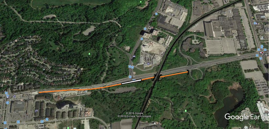
Have the Crosstown Line emerge out of the Brentcliffe portal as it is constructed now, but instead of routing at-grade, erect pillars and have the guide-way run elevated, cutting over the eastbound lanes of Eglinton to a side-of-roadway platform at the south side of the Leslie intersection (this could also have a pedestrian connection to the Vanderhoof Ave residences). Then east of the station, gradually have the guide-way descend back to ground level to cross the Midtown rail corridor. Then by the Celestica ramps go completely underground to enter Science Centre Stn. Any thoughts on this proposal?
Developing the idea farther:
  • From the portal just East of Scenic, to get the elevation to pass over the eastbound lanes (EBL), the line would have to rise quickly and then pass over the EBL east of the Don River Bridge with an S curve.
  • The station would be (west) half elevated
  • Then go under/through the rail embankment. Three tunnels needed I think, 1 for pedestrians, 1 for each direction of LRT.
  • The Celestica ramps are at various elevations and will most definitely interfere with the LRT line - thus I propose it be changed to a Diamond type interchange.
  • The line would go back under the EBL of Eglinton west of Celestica and join the median alignment.
The next thing to consider is how this line could get over the DVP.

I found this Plan from an EA (I think 2012) and marked it up.

ECLRT at Leslie.jpg
 

Attachments

  • ECLRT at Leslie.jpg
    ECLRT at Leslie.jpg
    1.2 MB · Views: 656
Here's what I came up with at Don Mills.

  • The BIG problem is that there are cross-over tracks and pocket tracks west and east of the actual platform. Not only did these add 300m to the tunnel and a hundred million or more to the cost compared to if it was put on the south side of the road west of Don Mills. It also pushes the level portion of track farther East, meaning more aggressive grades are needed to elevate the track to get over the DVP (and off ramps).
  • They used 5.5% to obtain a stop at Ferrand. I continue this grade over the DVP, and then descend at 5% with a station above Wynford.
  • The line switches to the south side since the DVP slopes downward a touch and it makes the grades work out a bit better.
  • The only concession appears to be that the Southbound offramp right turn ramp may need to be tightened up to achieve the vertical clearance for the elevated track.
  • (sorry, my plan/elevation diagram cuts out just before Wynford, and I just sketched that in). The Wynford interchange ramp configurations would remain as existing.
ECLRT at DVP.jpg
 

Attachments

  • ECLRT at DVP.jpg
    ECLRT at DVP.jpg
    1,022.5 KB · Views: 662
re: discussion about Sheppard Subway extensions in Shepp thread
With Line 3 becoming disused and the ROW essentially becoming available/salvageable, I think it could change the dynamic of previous Sheppard extensions considerably. All past reports had the line lazily drifting somewhere toward SC. However now I think planners/politicians will realize there's an opportunity to cut the costs by having the line elevated (gasp!) through SC - perhaps as far as Markham Rd/Centennial. Not unlike past SRT routings.

Looking at all ridership modeling it wouldn't make a lot of sense to build for 150m trains / +30k pphpd capacity. But 100m lengths (+20k capacity) should theoretically cut the costs by a good margin, and have the line future-proofed for this millennium. Combined I think these could be very helpful to the project's cost-benefits case.

2011 KPMG report routings
Sheppard-extension-to-SC.jpg


possible routing using disused Line 3
Sheppard-extn-using-Line3ROW.png
 

Attachments

  • Sheppard-extension-to-SC.jpg
    Sheppard-extension-to-SC.jpg
    90.1 KB · Views: 518
  • Sheppard-extn-using-Line3ROW.png
    Sheppard-extn-using-Line3ROW.png
    426.8 KB · Views: 739
The route may be salvageable, but is it desireable? I feel like the extension will more likely go as far on Sheppard as possible before turning south to meet BD. Which I guess would be a clever way of them to get that last part of the BD that was cut....
 

Back
Top