News   Jul 12, 2024
 1.3K     0 
News   Jul 12, 2024
 1.1K     1 
News   Jul 12, 2024
 387     0 

Transit Fantasy Maps

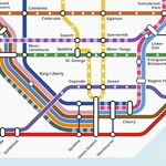
View attachment 18466

Not so much a fantasy map as a relatively inexpensive alternative to the current system which could prove to lower some of the current strain on the Yonge-University-Spadina line, by interlining the system (as has been tested previously) and splitting it into four lines one could control for the problems faced with different levels at Bay Station, the realignment would need about a kilometer of new track reconnecting Lower an Upper Bay stations in new ways, the alignment depicted allows all North-South trains to be on the lower level at all time, and all East-West trains to use Upper Bay exclusively. With some re-signing downtown and the addition of an automated announcement system, along with the new signalling system being installed in a few weeks, one could reasonably expect to have a train going almost anywhere in the city with a minimum head way of two minutes, or 30 seconds between each train (headway for trains on the YUS line after this October's shutdown).

This system could not serve to replace the idea of a Downtown Relief line, but it could reduce some of the strain on the current system and buy the city some time to build the a new line. I welcome any criticism to the map or the idea, I'd like to see this actually go somewhere, and I'm hoping its' relative simplicity and low cost make it attractive. It would also be possible to examine the idea of adding a Cross-Bloor express train that does not do the entire loop and runs the current Bloor-Danforth line in peak periods, allowing those crossing downtown to bypass it and avoid a transfer.

Contra Wizard. -First time poster, long time reader.

Edit: Sorry my pain skills suck.

Edit 2: Large Image at: http://i.imgur.com/fSRuwKR.gif

If I understand this correctly, trains will be come every 30 seconds on the downtown portion of the Yonge and University Line (i.e. Queen or Osgoode Station). One train goes north to Finch, one goes east to Kennedy, one goes North to Downsview and one goes West to Kipling. If you cross to the other platform, there would also be a train going to each of the 4 termini (Finch, Kennedy, Downsview, Kipling), but it would go the long way around the loop through Union Station.

This means it is a 2 minute wait, maximum, to get a train going to your destination. It may even be a one minute wait if you are willing to go the long way around through Union. I guess it also means that outside of the downtown loop, the train frequency (i.e. at Jane, Yordale, York Mills and Victoria Park) would be 60 seconds (in each direction).

The 30 seconds seems unrealistically low to me. Currently, I think we are above 2 minutes and are hoping to get down to 100 seconds with the new signalling. This proposal may allow higher frequency since the dwell time at each station would be reduced since there would be much fewer transfering riders at interchange stations (there would still be transfers at +/- Bay for passengers who want to continue along Bloor) and fewer riders at each typically station since the frequency is lower. However, that being said, 30 seconds seems exceedingly low and I would think that the value of 90 seconds suggested by Gweed123 is a more reasonable value. If I use an 75 second value for train frequency in the downtown loop, then outside of the downtown loop (i.e. at Jane, Yordale, York Mills and Victoria Park), the the train frequency would be 150 seconds (2'30" in each direction) - about 15% worse than currently exists and about 40% worse than what TTC hopes to achieve with the new signals.
 
However, that being said, 30 seconds seems exceedingly low and I would think that the value of 90 seconds suggested by Gweed123 is a more reasonable value.

TTC actually achieving 90 second headways is going to take a lot more changes than what is currently budgeted for and many of the constraints are in the downtown section.

Reliable headways under 120 seconds from St. George to Bloor will not happen within a decade.
 
Last edited:
Interesting idea, and welcome to UT!

The interlining scenario certainly has some merit. I just have to question the feasibility of building a new partial wye around Yonge & Bloor. I mean, the Yonge Subway through that area isn't very deep, and there are many more buildings with deep parking garages underneath than there were when it was built in the 50s. I know the map isn't exactly to scale, but specifically the N to E crossover from Wellesley to Sherbourne, that would have to cut through a sea of condo and office tower parking garages in order to match the grade of the existing Yonge Subway. Also, the section of the Bloor line from Yonge to Sherbourne was TBMed (or at the very least not cut-and-covered, but I believe it was in fact TBM), so building a new wye in that area may also be very difficult.

Also, I would add a through-route on the Bloor-Danforth line, because there are quite a few trips that cross Yonge. Even in the original interlining scenario the TTC had, there was still a route that ran from Kipling to Kennedy (or at that time I believe it was Keele to Woodbine). You'll also need that in order to maintain adequate headways. With 4 routes running downtown and assuming a minimum 1.5 min headway, you're looking at a minimum of 6 min frequencies on each of those branches. If you want to cut that down a bit, what I would suggest is running 2 routes on B-D instead of 3: One that runs from end to end, and another than runs from end to end via the downtown loop. That would still get the diversion you're looking for, but wouldn't chew up so much headway time.

Very interesting idea though, and if they wye complications can be sorted out, certainly something that has merit.

I think the Wye could be built, but it would need to be done rather soon, the intersection is all torn up at the moment, and with the size of one Bloor I think building such a connection after it's complete would be near impossible, the wye I had in mind is at the level of lower bay, not the current upper level. I had thought I had mentioned the possibility of a Cross-Bloor Express line operating in peak periods, but I may have forgotten to mention that in my UT post.

Looks like the 30Sec headway I remember seeing somewhere in a press release about this October's weekend closures was a bit of a fallacy, even at 90 seconds the system would prove to be a decent relief to current YUS congestion as the province and city come to terms with the ever increasing need for a Downtown Relief Line - something I'd very much love to see before I leave this beautiful city once more.
 
TTC actually achieving 90 second headways is going to take a lot more changes than what is currently budgeted for and many of the constraints are in the downtown section.

Reliable headways under 120 seconds from St. George to Bloor will not happen within a decade.

As I understand it, after the new signalling, I understand the biggest constraints of headway are for turning trains around at the termini, and the Y-B transfers. In this plan, the termini stations would all have a frequency twice the downtown frequency - so that is no longer a constraint. The Y-B transfers would be very much reduced because all trains lead downtown and alternate trains would take the Yonge or University portion of downtown. Of course, transfers would be eliminated since there are travellers who do not fit this typical travel destination. I agree that 90 seconds with the current transfers and termini are tough to achieve.
 
As I understand it, after the new signalling, I understand the biggest constraints of headway are for turning trains around at the termini, and the Y-B transfers. In this plan, the termini stations would all have a frequency twice the downtown frequency - so that is no longer a constraint.

It's not the terminal stations per say, it's the common switch points; which just happen to be at the terminal stations at the moment.

If you change the common switching points for the trains, you've moved the congestion point too and this plan involves a lot more switching including the odds of conflict (thus stopping a train). A stopped train going through a switching point takes even longer than one which got a running start.

The shared loop in Chicago is one of the reasons many of their lines have 7 minute frequencies. On occasion they get much higher frequencies through the loop but it isn't reliable enough to schedule super-high frequencies through it and they have the advantage of side platforms. Toronto's center platforms on the University section make this more difficult to time well.

The 9 Chicago Loop stations have a daily ridership of 80,226. TTC's King station is in the 60,000 range.


It can be done if you can layout the track without ever crossing a second track. For example, Westbound Danforth needs to somehow get over or under the Eastbound Danforth track, over or under the Yonge line, order or under the Northbound University track and join in. The grade changes and curves involved would take quite a bit more room than what has been drawn on that map.

Computer control can keep the gaps free by having a combined speed control but the transition still needs to be fast. Think highway interchange rather than a street intersection. Great idea for Sheppard & Yonge where few foundations are in the way; damn hard to retrofit through the maze of buildings at Bloor & Yonge.
 
Last edited:
I have a feeling all LRTs will be on the map, but it is pure speculation at this point. There is no reason to suspect that the underground portion of the Eglinton LRT won't be on the map however.
 
I have a feeling all LRTs will be on the map, but it is pure speculation at this point. There is no reason to suspect that the underground portion of the Eglinton LRT won't be on the map however.

The TTC has been pushing LRT as "rapid transit", so I expect it to be on the map.

Also it wouldn't make sense to only show 60% of the ECLRT. Of course the ROW parts of the line will be on the map. But it also wouldn't make sense to put the ROW of the ECLRT on the map and not the ROW of the FWLRT or the SELRT. So I expect all three to be on the maps. It's also best for customer service.
 
Here's some depressing news. Toronto has gone without 11 years without any subway expansion. That's the longest without any expansion in our history. Before 2002, we opened new subways every 4 years.

Yonge (Union Station to Eglinton) — March 30, 1954
(9 years)
University (Union Station to St George) — February 28, 1963
(3 years)
Bloor-Danforth (Keele to Woodbine) — February 26, 1966 (Feb 25)
(2 years)
Bloor West (Keele to Islington) — May 11, 1968 (May 10)
(N/A)
Danforth East (Woodbine to Warden) — May 11, 1968 (May 10)
(5 years)
Yonge North (Eglinton to York Mills) — March 31, 1973 (Mar 30)
(1 year)
Yonge North (York Mills to Finch) — March 30, 1974 (Mar 29)
(4 years)
Spadina (St George to Wilson) — January 28, 1978 (Jan 27)
(2 years)
Bloor West (Islington to Kipling) — November 22, 1980 (Nov 21)
Danforth East (Warden to Kennedy) — November 22, 1980 (Nov 21)
Scarborough RT (Kennedy to McCowan) — March 24, 1985 (Mar 22)
(2 years)
North York Centre Station — June 18, 1987
(9 years)
Spadina (Wilson to Downsview) — March 31, 1996 (Mar 29)
(6 years)
The Sheppard Subway — November 24, 2002 (Nov 22)
(11 years)
Today
 
it will be 14 before a new opening... then 6 for the ECLRT, then 3 for Scarborough, then (hopefully) 1 for the DRL, then (hopefully) less than 1 for the Yonge Extension
 
it will be 14 before a new opening... then 6 for the ECLRT, then 3 for Scarborough, then (hopefully) 1 for the DRL, then (hopefully) less than 1 for the Yonge Extension

Wow, so the ECLRT has been pushed back to 2022 now? Did it always take this long to building a subway line?

How do you figure that Scarborough will be complete in 2025? Is there a timeline posted by Metrolinx somewhere?
 
Last edited:

Back
Top