News   Jul 12, 2024
 1K     0 
News   Jul 12, 2024
 929     0 
News   Jul 12, 2024
 358     0 

Transit Fantasy Maps

The key is that this orientation is the most efficient way to fit KW/C into a single, contiguous, poster-shaped image.

if Cambridge were split off from KW, then it would be able to rotate as you wish, much like GRT maps already are, but the point of this map is clearly to show KWC as connected as possible.
 
The key is that this orientation is the most efficient way to fit KW/C into a single, contiguous, poster-shaped image.
If it uses an orientation that people don't expect, then it fails - even though it looks spectacular.

But I don't see that it needs to be a different shape. Surely you can rotate parts of the Waterloo and Kitchener streets 45 to 90 degrees, and still keep Waterloo on top, Kitchener in the middle, and Cambridge at the bottom.
 
If you were to do that, you would further distort the road network further and relative distances between points. In order to be remotely legible as Waterloo Region, that geographic relativism needs to remain intact.

The problem is that Cambridge is just as much east of Kitchener as it is South. To rotate the map would leave a large amount of negative space. Take a look at this map to see my point: http://rapidtransit.region.waterloo.on.ca/maps.html
 
Every major road in KW that most people expect to see going from left-to-right is instead going diagonally top-left to bottom-right. No one is used to a map like that. No matter how "correct" it would be, it would fail for that reason alone.

If you instead work on the basis that major roads like Northfield, Columbia, Erb, Victoria, Ottawa, Bleams, Roseville, Eagle, Bishop, Clyde, etc., are all straight right-to-left roads (along with the Stratford branch of the Conestoga) and then make roads like King, Fischer-Hallman, Hespler, Franklin, River, up-down, along with most of the north branch of the Conestoga and the 8 from the Conestoga to the 401, then you should have something that works, with only a bit of manipulation to put Cambridge on the same potrait-sized view (it helps a bit that it's a lot narrower than KW). You'll be left with a bit of negative space in the top right, and bottom left - but you'll have somewhere to put legends, etc.

Didn't the old Kitchener Transit maps in the 1980s and pre-GRT do something similar, where it was still all to scale, but showed Erb left-right, and Fisher-Hallman up-down?
 
It's a fantasy map for a contest. the orientation was a design choice to facilitate the use of standard 45 degree angels and to leave space for station names.

We could quibble about whether or not people would "Get It", but if you're up for the challenge, I suggest you make your own using your own guidelines so we can see how it looks.
 
Here's the final version of what I've been working on:

zE3hh.png

Quoting the awesome map again, as it is now 2 pages back.
 
Just one question, are you proposing that we in Malton lose our GO and VIA rail service? What have we done to deserve this?
 
If it's going to come in that way why not have it terminate at Renforth Gateway? IMO that's going to be a more important transit hub than Pearson will be.

Fair enough, as long as there is an anchor transit hub with multiple transit types serving it and some form of connection to the airport.
 
Precisely.

Okay, just I thought I read a few postings ago about having the line swing south after Bramalea and tunnelled under the airport which would then by pass our fair town.
Could we keep the name? After all a Malton train station has been around about 70 years longer than the airport. Or if we are looking to have an association between the airport and the train station we could call the airport Malton... oh yeah it was at one time wasn't it?:D
 
The naming isn't all that important to me as the network, as I don't live there. The network however would extend the people mover from Malton to Renforth, acting as twin transit gateways to the airport and styled similarly to Terminal 1
 
The naming isn't all that important to me as the network, as I don't live there. The network however would extend the people mover from Malton to Renforth, acting as twin transit gateways to the airport and styled similarly to Terminal 1
You can't extend the people-mover from Malton to Renforth. You'd have to build a completely different system. The people mover is so you have something like an elevator that moves people from Terminal to Terminal to the parking garages every 4-5 minutes or so. You wouldn't need that kind of frequency to Malton and Renforth, particularly off-peak.

As the Eglinton Crosstown is already planned to be extended to Renforth station and then to Terminal 1, then the simplest thing to do, is simply extend that to Malton GO.
 
As the Eglinton Crosstown is already planned to be extended to Renforth station and then to Terminal 1, then the simplest thing to do, is simply extend that to Malton GO.

Also a very good option. When thinking about extending the people mover, I was thinking more in terms of extending the ROW, using the same supports as the people mover,, and converting to LRT anyways. A gateway to the airport at Malton is a must though. Such a line could eventually be extended to meet the Finch West LRT.
 
here is my revised DRL routing, with stations this time!

I would like it do come down don mills, across overlea, down pape, across wellington, make the jump up to king in the st. Lawrence district, drop down to front past spadina, (so that it reaches GO's future transit centre at bathurst and front) down to exhibition/liberty village, up along the rail corridor to roncesvalle ave, and up to dundas west station.

phase one would be "peter" station to eglinton, or "science centre". propably in the 4-5 billion range for construction (hopefully largely federal funding). phase 2 would be "science centre" to "Don mills". probably around 1.5 billion to 2 billion (largely municipal funding through transit taxes). and phase 3 would be "peter" to "dundas west". probably around $2 billion. (provincial/federal/municipal funding, as it would largely be built to allow for "bathurst central" station for GO's transit centre.)

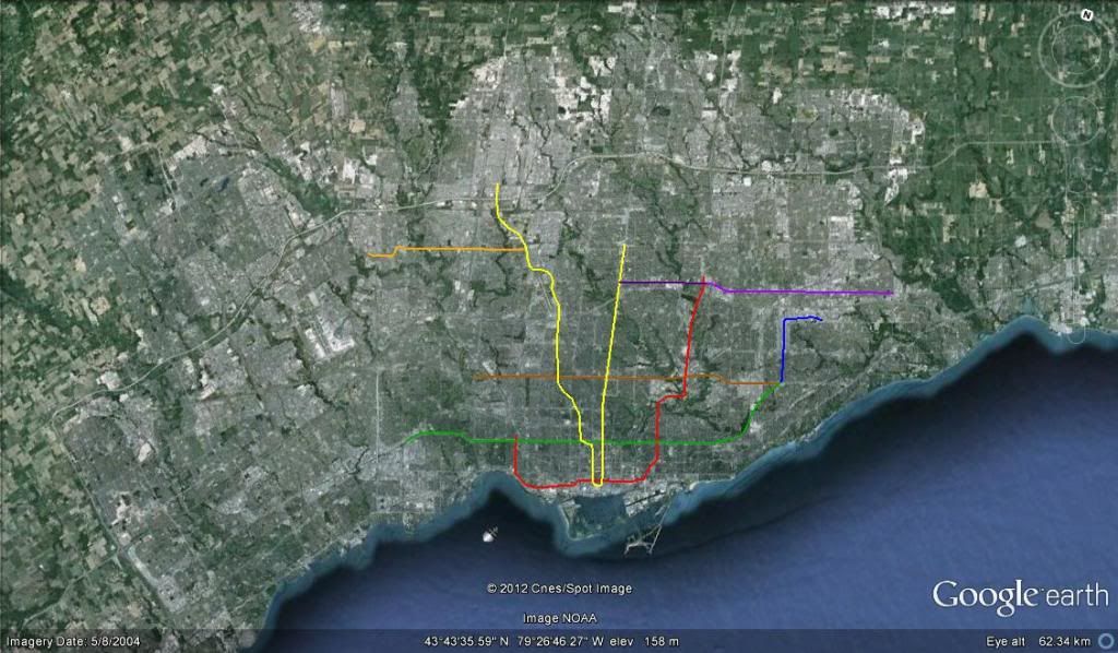
finally, some pics showing how it would be built;

line overview;

drl1.jpg


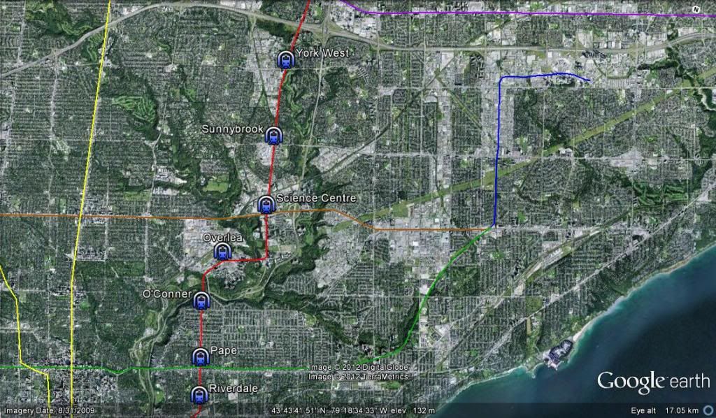
northern station locations; [EDIT: i only just noticed that don mills stations is just off of the pic. its there, trust me!]

drl6.jpg


station locations east of the don valley;

drl5.jpg


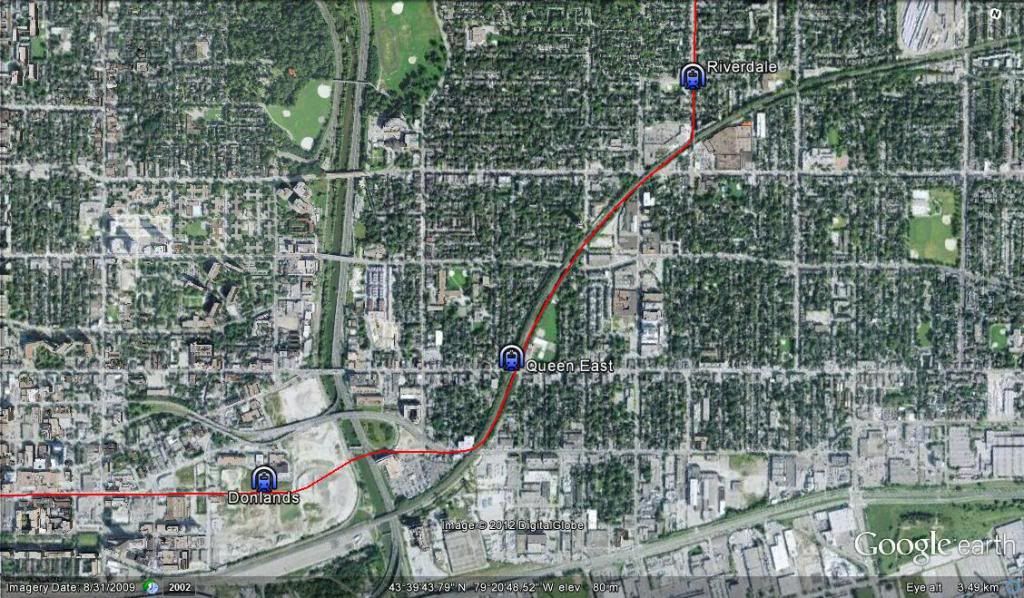
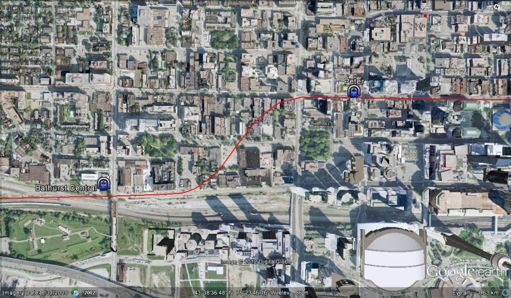
eastern stations in the core, showing the jump from wellington to king;

drl4.jpg


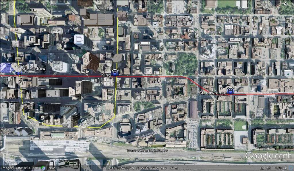
western core stations, highlighting the jump from king to front;

drl3.jpg


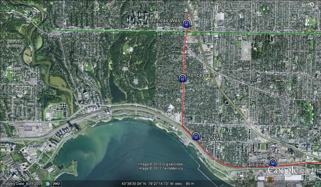
the western "Suburban" stations;

drl2.jpg


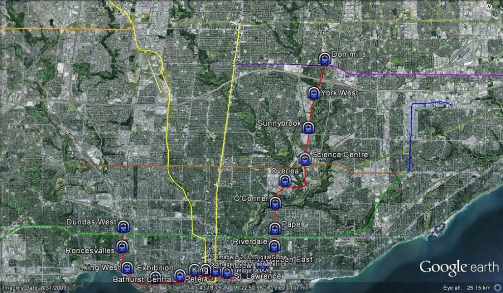
and an overall map showing all the stations on the entire route;

drl7.jpg
 

Back
Top