


W. K. Lis
Superstar
Yeah Back To The Future did correctly predict the revitalization of downtowns. Only one year until 2015 and still no flying cars or hoverboards though.
Tearing down the Gardiner is one step towards the flying car.
|
|
|
Yeah Back To The Future did correctly predict the revitalization of downtowns. Only one year until 2015 and still no flying cars or hoverboards though.
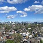
I drove through Bathurst between Sheppard and Eglinton today, and considering that it's often thought of as a suburban area, it was very urban.
Very high densities consistently, 5-10 story apartment buildings throughout the stretch, along with some shorter apartment buildings too. Lots of narrow storefronts with interesting non-chain retail. Lots of character due to the Jewish nature of the neighbourhood, Jewish restaurants, people in Hasidic Jewish clothing walking around (reminded me of Williamsburg Brooklyn).
It made me wish that the Spadina/University subway went underneath Bathurst instead of through a ravine & highway. It also made me think it would be cool if the streetcar continued north of Bloor into these areas.
I was just in New York where I stayed with a friend who lives in Forest Hills, Queens. Has somewhat of a similar feel to the Bathurst corridor.
I haven't been to Queens, but based on my impression from seeing photos and from movies & TV shows, it seems the borough most similar to most parts of Toronto in terms of built form. My impression is that it has lots of detached houses like Toronto, but also many 50's to 70's apartment buildings like Toronto as well.
By the way, it's quite interesting to me that there are lots of surprising pockets of pretty high density throughout Toronto's suburbs. You could be driving down a random street in the suburbs and stumble upon a forest of tall apartment towers, or clusters of low-rise apartment towers. They are often set back pretty far from the street and have trees around them as if to try and hide them. They mostly seem to be built in the 50's-70's and surrounded by surface parking.
I haven't been to Queens, but based on my impression from seeing photos and from movies & TV shows, it seems the borough most similar to most parts of Toronto in terms of built form. My impression is that it has lots of detached houses like Toronto, but also many 50's to 70's apartment buildings like Toronto as well.

Looking west of Toronto on the greenbelt map, the only municipalities with any greenspace left to develop are Oakville and Milton. 2011 census figures for the two were 182k and 89k respectively. Milton issued a statement after the results came out in 2012 that they had already passed 100k since the census was taken. 2031 projections put both municipalities above 250k.
Oakville began developing north of Dundas less than two years ago and already have a few thousand people living there now. Between Sixth Line and Neyagawa it's built up to about halfway between Dundas and Burnhamthorpe. Milton is completely built up to Louis Ste Laurent now. So that means there is now only about 7km of greenspace left between the two. Two years ago I measured it to be 9km. That's a lot of development in two years!
I give it 20 years for the two to become one. What's interesting is the thin greenspace strip they left between the two. Could that be in case they want to widen the 407?

There's several municipalities that still have greenspace left to develop, although part of the urban expansion lands have been built up since 2004, Brampton, Vaughan, Caledon, Ajax, Whitby, Oshawa, Clarington and Halton Hills still have space in the urban expansion lands. Nonetheless, Brampton, Vaughan and Markham, which have really been leading the pack in terms of greenfield growth in the last decade will probably run out of land in 10-15 years, combined with Richmond Hill, Mississauga, Aurora, Newmarket, Burlington and Pickering having run out more or less right now, it will be interesting to see what the effect will be.
If I remember right, the plan for the next 20 years was for Milton to develop up to the mid point between Britannia and Lower Base Line while Oakville would develop up to the 407. I wonder what Milton congestion will be like, will they use the 407 or just cram onto the 401? I guess it'll be similar to Brampton.
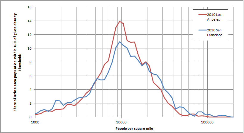
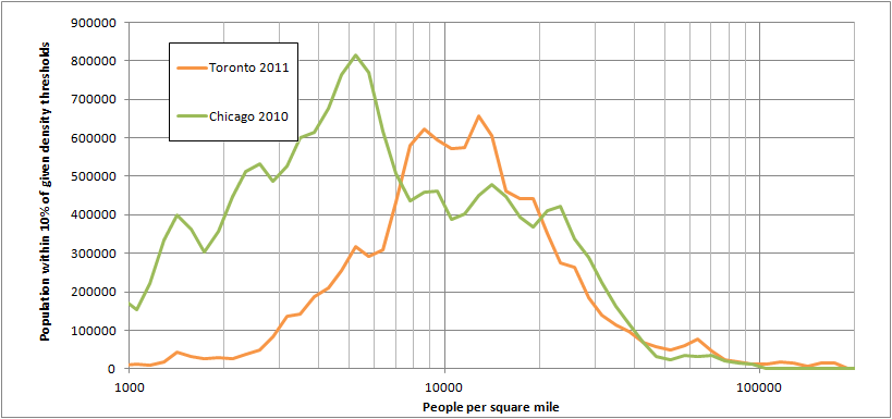
By the way, San Francisco, Los Angeles and Toronto have very similar urban areas in terms of density.
I compared LA and SF on my blog.
http://swontariourbanist.blogspot.ca/2014/03/san-francisco-and-los-angeles-density.html
There's several municipalities that still have greenspace left to develop, although part of the urban expansion lands have been built up since 2004, Brampton, Vaughan, Caledon, Ajax, Whitby, Oshawa, Clarington and Halton Hills still have space in the urban expansion lands. Nonetheless, Brampton, Vaughan and Markham, which have really been leading the pack in terms of greenfield growth in the last decade will probably run out of land in 10-15 years, combined with Richmond Hill, Mississauga, Aurora, Newmarket, Burlington and Pickering having run out more or less right now, it will be interesting to see what the effect will be.
I thought Vaughan and Markham would be built out 10-15 years from now if they were to use up land at a similar pace to the past. It sounds like they might be using up land more slowly than in the past according to what you're saying? In that case my point still stands, it will be interesting to see what the effect of reduced land for greenfield development will be.If we're going by Places to Grow and talking about York Region, only Markham, Vaughan and East Gwillimbury have "whitebelt" lands that are neither in the greenbelt nor the built boundary. Markham opened up close to 1/2 of theirs (maybe less?) but still have something like 1,000 acres not open to development - that's out to 2031. Vaughan opened up more, but still have some,so they won't be built on in 2031 either (at least not as currently planned). Aurora, Newmarket and Richmond Hill are effectively there already, in terms of planning, if not in terms of actual construction yet. So, it kind of depends how you define "will run out of land in 10-15 years" but Markham and Vaughan still have plenty left and intend to have some left 20 years from now.
(Oh, and Chinatown and Who Framed Roger Rabbit? are both fundamentally about the creation of urban sprawl and should be on that list of urbanist movies.)
Dead End: Suburban Sprawl and the Rebirth of American Urbanism
By Felipe Azenha On March 30, 2014 ·
Related posts:
