Toronto Ontario Line 3 | ?m | ?s | Metrolinx

So reading through this there are several questions that are on my mind.

1. If we don't get Fare integration before OL launches, how will fares be handled? Are we simply going to have presto readers on the platforms and risk people evading fares with POP? Not to mention, isn't it possible people might be confused especially those who aren't familiar with the system to which presto machine will be for OL, and which will be for GO?

2. What will the amenities look like. Can we expect Bus loops or streetcar loops? Especially true for a route like 505 DUNDAS if we are going to route the streetcars there similar to what W. K. Lis is suggesting.

3. How much room will there be for VIA HFR trains if that becomes a thing? Will they have to share tracks with LSE and Stouffville Express trains?
1. Hopefully all the OL stations will have the TTC fare gates. The ones used for GO can be the same new ones that are being implemented currently.

2. Most of the bus stops/streetcar stops along the route would likely be on-street. I could see one or two bus loops being incorporated into the Ontario Line. For example, I could see 88A and 88B South Leaside terminating at Thorncliffe Park Station. The 81 bus route would likely be terminated upon opening. For Gerrard, it looks like the SmartTrack station won't be going ahead as planned. But in the old plan for the station, there was a plan for a bus loop for the GO station.

1601413043143.png


3. Good Question. I don't follow the Via HFR project often so I'll leave that to someone else.
 
3. How much room will there be for VIA HFR trains if that becomes a thing? Will they have to share tracks with LSE and Stouffville Express trains?
If the HFR trains use a Peterborough routing, we might not even see those trains on that corridor. We'll have to see if those trains will end up on the Midtown Corridor instead.
 
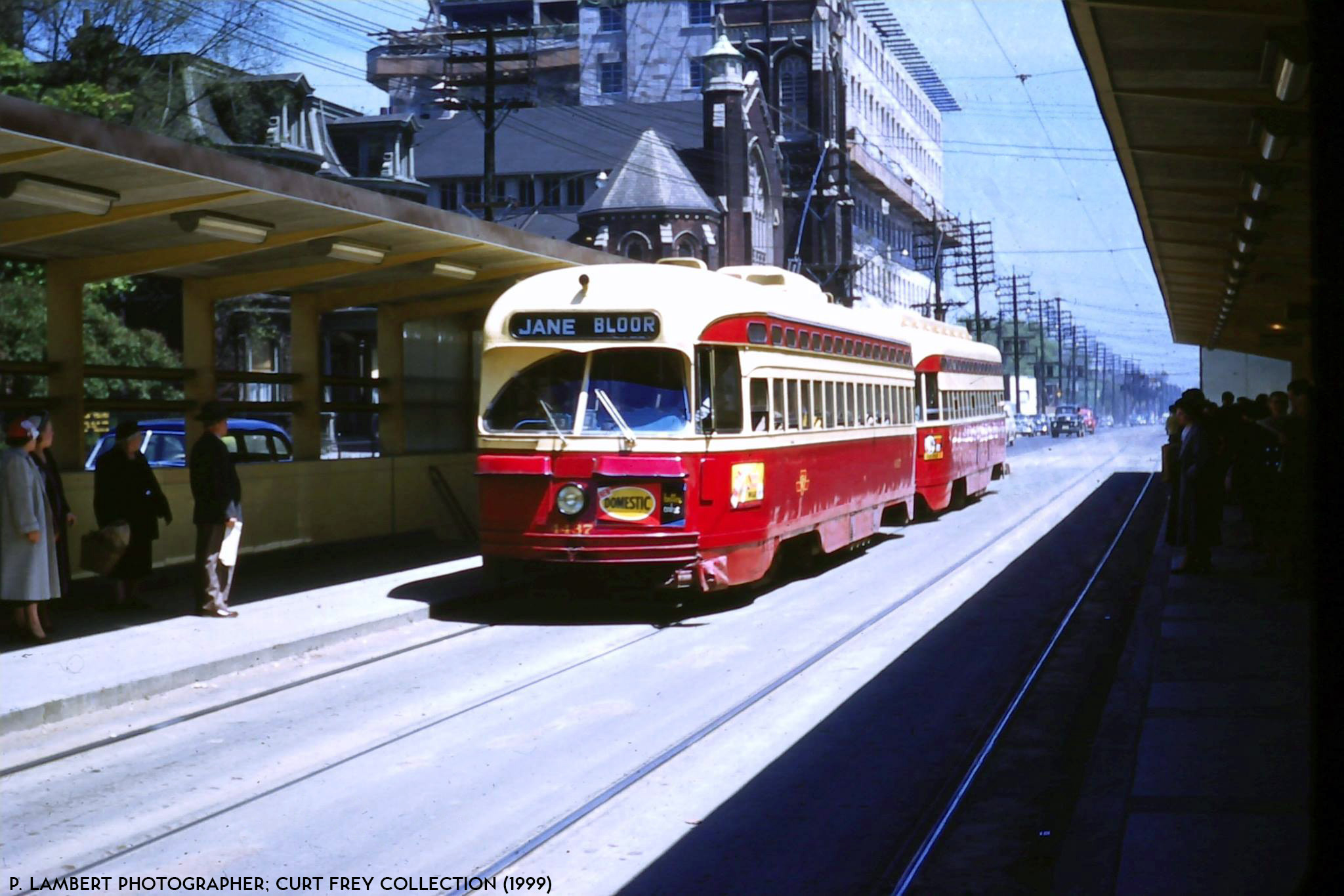
I could see transfer platforms similar to the old Bloor streetcar transfer with the then new Yonge Subway Line at the Leslieville Station for the 501 & 502/503 streetcars, and at the Gerrard Station for the 506 streetcar. The Gerrard Station could have an setup for a transfer for 506 short-turns and 505 streetcars.

streetcar-4115-07.jpg

ttc-4660-bloor-1955.jpg

From link.
 
1. If we don't get Fare integration before OL launches, how will fares be handled?

2. What will the amenities look like. Can we expect Bus loops or streetcar loops? Especially true for a route like 505 DUNDAS if we are going to route the streetcars there similar to what W. K. Lis is suggesting.

1. If the fares are too high, then the ridership numbers will be way lower than expected, and won't actually deliver "relief" to Line 1. If there's no fare integration, I'd expect the TTC fare to include the Ontario Line. Line 5 Eglinton will be the same.
Another factor depends on what the payments to the P3 will be - some projects have a "ridership" clause where they get an amount depending on the number of riders carried.

2. No idea yet - no mention of this at all yet other than vague "the station will provide a connection to" etc. Given the current provincial government, I'm worried it might be a case of "if you want something, you better pay up".
[Noise wall] Public art surface treatments would be procured, funded, implemented and maintained by municipalities or other third parties.
Well look, a perfect example of this.
 
“We are maximizing our use within the GO property but some tiny slivers outside the current corridor boundaries will be impacted in the final buildout,” said MacKay. “In most places, it will be as little as a foot.”

Sounds like great news, though almost all of these blogs paint a sunny picture of everything.

I'm curious to see what areas will be impacted and the local community response.

I hope the bridge is an early rendering and not close to the final design.
 
The problem is not going to be resolved by extending the Sheppard Line, unless the OL/DRL is extended to Don Mills.

You don't get it right now, and that's okay. I don't have any further comments on your post to me.

Let's come back to this conversation in 2030.
 
So reading through this there are several questions that are on my mind.

...

3. How much room will there be for VIA HFR trains if that becomes a thing? Will they have to share tracks with LSE and Stouffville Express trains?


If the HFR trains use a Peterborough routing, we might not even see those trains on that corridor. We'll have to see if those trains will end up on the Midtown Corridor instead.

There has been some discussion in the VIA thread that HFR might use the Stouffville Line to get to the CP Belleville Sub (before joining the Havelock Sub.). So until something becomes public by the VIA HFR process, we can't say for certain that VIA wouldn't want to use this stretch to get to CP's Belleville Sub. At least, that would be my cautionary note. cc @crs1026 @smallspy
 
This looks a lot closer then that:

eastsegmentmap.png

I strongly suspect that picture is inaccurate and needs to be republished or something. It shows the line going directly over Strange St and through the Fontbonne Ministries building.

That doesn't match this picture, which looks significantly more in line with what Metrolinx said in their blog post today.
1601416561838.png
 
1. If the fares are too high, then the ridership numbers will be way lower than expected, and won't actually deliver "relief" to Line 1. If there's no fare integration, I'd expect the TTC fare to include the Ontario Line. Line 5 Eglinton will be the same.
Another factor depends on what the payments to the P3 will be - some projects have a "ridership" clause where they get an amount depending on the number of riders carried.

With regards to fare integration, it's more of an issue with GO/RER transfers at East Harbour, than the fare of the OL. The different fares for GO and TTC can be a barrier for transfers at that station (like at Union now); especially an important issue if there is an intention for the OL to relieve the Union corridor, although that is secondary to relieving Line 1+2, which it will accomplish regardless of fare integration between GO and TTC. OL itself operates no different than a TTC subway line (just like Line 5) and will have the same fare as the TTC; the ridership will be high even if GO still keeps the same fare structure it has today (unlikely, probably will change by the time this line is opened).
 
The platforms on that Leslieville close-up diagram seem a lot longer than 100m (compared to the Gerrard diagram).
The other thing is that the Leslieville entrances will be from Queen St. E., so for practical walking purposes the entrance will be the furtherst distance away from the East Harbour Station as it can get.
At East Harbour Station, the long platform shown would be the GO platform. The Ontario Line platform would be the darker section in the middle, a bit further west from the end.

Also note that on the Pape section, there is no end of the station shown at Danforth, so the Pape Station will probably lie wholly to the north of Line 2.

papesouth_comp.jpg


***********

Yeah, there should definitely be fare integration so you can transfer to/from GO and TTC without additional charge.
The Presto card should easily do that from a technical perspective. Vancouver's Compass card does. When you exit the faregates for Westcoast Express or SkyTrain then tap on a bus, or vice versa, the system knows that those are linked trips (within a time limit) and doesn't charge you again. No need for gated bus loops / transfer areas - passengers just tap for each mode used (which also provides ridership data).
 
Last edited:

Back
Top