Toronto Eglinton Line 5 Crosstown West Extension | ?m | ?s | Metrolinx

^I could be convinced to shorten that even more. It would be interesting to know whether building portals at each end of those four major intersections, with at grade in between, is cheaper than one continuous tunnel.

- Paul
 
I don't think of royal York as being a major intersection compared to the other three. I would just stay at surface until islington.
 
Just my 2 cents that I will conceed that there can be some merit to having the line underground between Royal York and Martin Grove. However, having the line buried from Martin Grove to Renforth/Commerce is asinine and a complete waste of money for so many reasons. There is literally no density there and a noodle of highways. At grade/Elevated would more than suffice.

It shouldn't be any more than this.

View attachment 234070
The key is the Eglinton intersection with the 401 off-ramp.
First, there is a separate study about re configuring this to improve traffic, reduce weaving, etc. This has not been considered.
With the current location of this intersection, it is not possible for the line to elevate east of Mimico Creek, especially on the south side.
- The repercussions of this are to be deep enough to go under Mimico creek, it has to stay underground much for much longer. (You could likley stay north of Eglinton and go over Mimico Creek there, but then the repurcussions are thatyou have to stay north of Eglinton and cross over the entire interchange at/near the highest point, and come back to earth 1.5 to 2.0km later vs. <500m if you went under the end spans of all the Eglinton bridges.
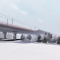
 
Why not just keep the whole thing at the surface with duck-unders/overs at Islington, Kipling and Matrin Grove. Tunneling seems rather extreme if all we’re trying to do is avoid congestion at three intersections
The IBC mention ML favours running ATO between Renforth and Laird.
 
The key is the Eglinton intersection with the 401 off-ramp.
First, there is a separate study about re configuring this to improve traffic, reduce weaving, etc. This has not been considered.
With the current location of this intersection, it is not possible for the line to elevate east of Mimico Creek, especially on the south side.
- The repercussions of this are to be deep enough to go under Mimico creek, it has to stay underground much for much longer. (You could likley stay north of Eglinton and go over Mimico Creek there, but then the repurcussions are thatyou have to stay north of Eglinton and cross over the entire interchange at/near the highest point, and come back to earth 1.5 to 2.0km later vs. <500m if you went under the end spans of all the Eglinton bridges.

If we assume that coming westwards the line will be below grade with an underground station at Martin Grove, is it fair to say that the only impact will be to the west of that?

I can understand if the location of roads, gas lines, etc forces some tunnelling at this point. It's a more technical challenge than east of Martin Grove, a bit of threading the needle. The goal would be to get the line back to grade as quickly as these impediments allow, well east of Renforth.

- Paul
 
So what? the trains will be manned anyway, and it will be a TTC operated line. Hardly worth the expense of a full tunnel.
The underground portion of Eglinton Crosstown will operate using ATC, even though it is manned (switching to manual once it's surface east of Laird).
 
The key is the Eglinton intersection with the 401 off-ramp.
First, there is a separate study about re configuring this to improve traffic, reduce weaving, etc. This has not been considered.
With the current location of this intersection, it is not possible for the line to elevate east of Mimico Creek, especially on the south side.
- The repercussions of this are to be deep enough to go under Mimico creek, it has to stay underground much for much longer. (You could likley stay north of Eglinton and go over Mimico Creek there, but then the repurcussions are thatyou have to stay north of Eglinton and cross over the entire interchange at/near the highest point, and come back to earth 1.5 to 2.0km later vs. <500m if you went under the end spans of all the Eglinton bridges.

I would say that At-Grade is sufficient through this location.
 
If they have to appease Doug Ford and go underground with the Eglinton West LRT, they'll have to rezone all the surrounding neighbours along Eglinton Avenue West in Etobicoke from low-density to high-density.

Start with Tettenhall Road (Doug Ford's street).

Can see this next door to Doug's house.

 
If they have to appease Doug Ford and go underground with the Eglinton West LRT, they'll have to rezone all the surrounding neighbours along Eglinton Avenue West in Etobicoke from low-density to high-density.

Start with Tettenhall Road (Doug Ford's street).

Can see this next door to Doug's house.

They should have done this with the Sheppard and the Spadina subways a long time ago. Look at VMC, it's booming and so much more is getting started. There is a clear demand for land in this city, especially cheaper land. Developers seem to only be focussing on Downtown because it's zoned for high-density development.
 
They should have done this with the Sheppard and the Spadina subways a long time ago. Look at VMC, it's booming and so much more is getting started. There is a clear demand for land in this city, especially cheaper land. Developers seem to only be focussing on Downtown because it's zoned for high-density development.
Maybe they're focusing on downtown because that's where people want to live.
 
Maybe they're focusing on downtown because that's where people want to live.
So we're just going to ignore the city's lack of willingness to rezone areas of the suburbs?
Look at downtown:
Screen Shot 2020-03-04 at 3.12.31 PM.png

People can build there because the current zoning bylaws allow for it.

Even in old Toronto, they have zoned the major transportation corridors for High-Density Commercial/Residential.
Screen Shot 2020-03-04 at 3.13.13 PM.png


But Sheppard Avenue?
Screen Shot 2020-03-04 at 3.11.26 PM.png


How about Spadina Line Subway stations?
Screen Shot 2020-03-04 at 3.11.51 PM.png


It's worth noting that yellow areas generally correlate to height restrictions of 10m (3 stories) on Spadina and Sheppard, but 12-16m downtown.

Frontage limits also heavily influence the density of the surroundings.

People want to live where it's affordable and safe. I'd live closer to my work along the Spadina subway if rent wasn't 2.5K a month up there. It's not like downtown is the most expensive place in the city
 

Back
Top