News   Nov 26, 2024
 106     0 
News   Nov 26, 2024
 451     0 
News   Nov 26, 2024
 388     0 

Sheppard Line 4 Subway Extension (Proposed)

I'd like to think Ford would just leave it alone; he gains nothing from cancelling it. Its not like he can cancel it and put a subway in its place because he has like 5 other subway projects to pay for now.

That said, either he or Rob did propose a subway on Finch once, so its not outside the realm of possibility. But I think its too far along to cancel.

On the other hand, the public seems to care very much about gas plant scandals and absolutely nothing about transit scandals so.....
He could say it needs to be redesigned as grade-separated.
After costs are derived for underground and elevated, Ford could say there is only money for elevated.
By the time they get around to actually building it, likely 4 years would have passed.
 
What is the Sheppard Loop?
It’s implied that the “Sheppard Loop” is the Sheppard East Subway Extension to STC in order to connect with the Line 2 Scarborough Subway Extension. I recall sometime during the campaign that the Sheppard Subway Extension was mentioned, but the specific route wasn’t.
 
What is the Sheppard Loop?

It’s implied that the “Sheppard Loop” is the Sheppard East Subway Extension to STC in order to connect with the Line 2 Scarborough Subway Extension. I recall sometime during the campaign that the Sheppard Subway Extension was mentioned, but the specific route wasn’t.

Ta da

rob-doug-ford-subway-map.jpg
 

Attachments

  • rob-doug-ford-subway-map.jpg
    rob-doug-ford-subway-map.jpg
    86.6 KB · Views: 844
What is the Sheppard Loop?

Seems to be east to McCowan. It's a bit confusing because in the past I'm sure I've heard west extensions referred to as 'closing the loop', and he didn't really state it until later.


Ignoring the proposals within and focusing on the cartographic aspect, this imo was the best political transit map in maybe decades. Tory's - garbage (why change Line 2 from current green to red, then make his ST some faded ugly seafoam green). Chow - blech, quick n dirty ms paint. Goldkind - disjointed bent lines are unprofessional. Stintz - wasn't really a schematic. Then Miller's Transit City and this godawful thing that looks like it comes from a restaurant flyer. Ford's otoh was well done.
 
Seems to be east to McCowan. It's a bit confusing because in the past I'm sure I've heard west extensions referred to as 'closing the loop', and he didn't really state it until later.

What I find most confusing is that our illustrious Premier wants this intersection:

https://www.google.com/maps/@43.7898249,-79.2587782,3a,75y,191.31h,108.57t/data=!3m7!1e1!3m5!1sxq-U5KIwv51uDRMIJqHfcA!2e0!6s//geo3.ggpht.com/cbk?panoid=xq-U5KIwv51uDRMIJqHfcA&output=thumbnail&cb_client=maps_sv.tactile.gps&thumb=2&w=203&h=100&yaw=277.16342&pitch=0&thumbfov=100!7i13312!8i6656

to be served by two subway lines.

I also wonder if he'll start pushing for all of Eglinton to be buried - on his map he says it's a subway extension, but I'm sure it's just burying the LRT. I'd imagine that would add at least a billion to the price tag.


Ignoring the proposals within and focusing on the cartographic aspect, this imo was the best political transit map in maybe decades. Tory's - garbage (why change Line 2 from current green to red, then make his ST some faded ugly seafoam green). Chow - blech, quick n dirty ms paint. Goldkind - disjointed bent lines are unprofessional. Stintz - wasn't really a schematic. Then Miller's Transit City and this godawful thing that looks like it comes from a restaurant flyer. Ford's otoh was well done.

I've seen much better looking Transit City maps than the one you linked. :p
 
Two always seemed a little ridiculous at that intersection. BD should eventually head north of the STC or Sheppard/McCowan (beyond 2051), but if the sheppard subway is extended east, it should connect at the STC because of the bus terminal.

If ford think's this is the best place to terminate 2 subway lines, we better start designing the best bus terminal in the world and make this a transfer point for a SELRT to morningside and beyond (or something).
 
Option 5 of the Relief Line North, could connect with Line 4 Sheppard in the Consumers Road area to provide a continuous route for commuters to bypass the crowds on the Yonge leg of Line 1, without transferring. It could even eventually be extended westerly to terminate at Sheppard West Station.

12-840x1024.png


This proposal is appealing. Option 5 for the Relief Line North (serving Thorncliffe / Flemmington / Science Centre, then swinging further east to Vic Park), and connecting to the Sheppard line from the east.

However, I would modify it slightly: split the Relief Line into two branches, around Vic Park / Sheppard or at Consummers. One branch would absorb the Sheppard line, while the other branch would continue north and reach Steeles. The demand on the Relief Line will be higher than on Sheppard, hence it would be reasonable to send half of the Relief Line trains north to Steeles, and the other half west on Sheppard towards Yonge.

The branch going north from Sheppard would only be viable if it were on the surface, to save tunneling costs. Other wise, a eastern extension of the Finch LRT could swing south on Victoria Park to connect with the Sheppard East LRT and continue east.
 
Option 5 of the Relief Line North, could connect with Line 4 Sheppard in the Consumers Road area to provide a continuous route for commuters to bypass the crowds on the Yonge leg of Line 1, without transferring. It could even eventually be extended westerly to terminate at Sheppard West Station.

12-840x1024.png
It seems that they are willing to spend any amount of money to prevent the Sheppard subway from reaching Scarborough.
 
It seems that they are willing to spend any amount of money to prevent the Sheppard subway from reaching Scarborough.

Technically, the Vic Park section of the combined RLN - Sheppard line will run within the old borders of Scarborough, and will have about 3 stations there (Lawrence, Ellesmere, Vic Park & Consumers). It will dramatically improve transit for the residents of the western part of old Scarborough.
 
Technically, the Vic Park section of the combined RLN - Sheppard line will run within the old borders of Scarborough, and will have about 3 stations there (Lawrence, Ellesmere, Vic Park & Consumers). It will dramatically improve transit for the residents of the western part of old Scarborough.
But Consumers is in North York.
 
But Consumers is in North York.

"Mostly" in North York. However, there is an eastern overflow into Scarborough.

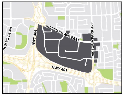
95e6-City-Planning-SIPA-ConsumersNext-Study-Area-Map-500x386.jpg

See link for "ConsumersNext" for Consumers Road Business Park.

The ConsumersNext study area is almost 100 hectares in the areas of North York and Scarborough.
 

Back
Top