News   May 17, 2024
 2.9K     5 
News   May 17, 2024
 2K     3 
News   May 17, 2024
 11K     10 

Rob Ford's Toronto

Status
Not open for further replies.
I'm really pleased that he showed up to support something that's both a really smart use of space and very urban. Ford has a "good news" day for a change.
 
Considering he and his brother's take on WT (i.e. tr is the biggest boondoggle), and their attempt to short circuit the Portlands, it is pretty disgusting to see him rub off the labour of others, as if it is something they support from day one.

AoD
 
/\ Agreed. Ford has no business associating himself with any of the accomplishments of WT. The public needs to be reminded about how the Fords tried to kill off WT by attempting to seize control of the WT lands in order to sell off the lands through Build TO.
 
Doesn't matter; he's in his right element in a playground w/kiddies. (He really should have a Brian Wilson-style sandbox installed in the Mayoral office.)
 
With his new embrace of urban parks, do you think Mayor Ford would consider an urban event like this? Summer Streets in New York City closes down major streets (like Park Avenue) to cars so that they may be enjoyed by pedestrians and cyclists, and provide activities for the whole family. This happens on three Saturdays in August.

Didn't we used to have something similar, where Yonge St. (was it called the Yonge Street Festival?) where the street was closed to traffic and there were assorted activities at the major intersections? What happened to that?

Join us for the fifth annual Summer Streets! On August 4, 11 and 18 from 7 am to 1 pm, nearly seven miles of New York City's streets will be opened up for everyone to play, run, walk and bike. From the Brooklyn Bridge to Central Park, along Park Avenue and connecting streets you can rock climb at Spring Street, receive a free bike helmet at 51st Street, soar through the air on a zip line at Foley Square or just stroll along and experience the city's streets in a new way—all for free.
 
Last edited:
With his new embrace of urban parks, do you think Mayor Ford would consider an urban event like this? Summer Streets in New York City closes down major streets (like Park Avenue) to cars so that they may be enjoyed by pedestrians and cyclists, and provide activities for the whole family. This happens on three Saturdays in August.

Didn't we used to have something similar, where Yonge St. (was it called the Yonge Street Festival?) where the street was closed to traffic and there were assorted activities at the major intersections? What happened to that?

Rob Ford has made clear time and time again, it's that roads are for cars, and cars alone. City council on the other hand...
 
With his new embrace of urban parks, do you think Mayor Ford would consider an urban event like this? Summer Streets in New York City closes down major streets (like Park Avenue) to cars so that they may be enjoyed by pedestrians and cyclists, and provide activities for the whole family. This happens on three Saturdays in August.

Didn't we used to have something similar, where Yonge St. (was it called the Yonge Street Festival?) where the street was closed to traffic and there were assorted activities at the major intersections? What happened to that?

Not a full shut down like they do in NY or used to do here, but between Aug 17 and Sep 16, Yonge will be reduced to one lane, each direction, between Queen and Gerrard. The website isn't fully up yet, but should be soon.
 
Unless Rob is visited by the ghost of Toronto future, this would be a nightmare in Rob's mind:

From The Guardian at this link.

Paris to return Seine to the people with car-free riverside plan
City mayor behind Paris Plages wins fight to pedestrianise large sections of 1960s expressway on left and right bank

Paris-pedestrianisation-p-008.jpg

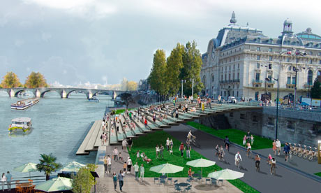
A computer generated image of the 2.5km car-free zone on the left bank in Paris, between the Musée d’Orsay, above, and the Pont de l’Alma. Photograph: JC Choblet

It's the latest battle in Paris's war on the private car: a pedestrian "reconquest" of the banks of the Seine.

After a slanging match with the right, the city's Socialist mayor, Bertrand Delanoë has won his quest to break up the two-lane urban motorway that has run along the edge of the Seine since the 1960s, and return Paris's riverside world heritage sites to walkers and cyclists.

From next month, a stretch of more than 1km (0.6 miles) on the right bank near the Hôtel de Ville will see the first narrowing of the road to make way for pedestrian corridors, riverside walkways, bars and cafes. Then in the spring the final promised masterpiece of pedestrianisation will be unveiled: a 2.5km car-free zone on the left bank, between the Musée d'Orsay and the Pont de l'Alma, with a riverside park, pedestrian promenades, floating botanic gardens, flower-market barges, sports courts, restaurants and even perhaps an archipelago of artificial islands.

The pedestrianisation of one of Europe's most picturesque urban riversides means the death knell for the Seine's non-stop riverside expressways. These were the pride of Georges Pompidou in the 60s when France's love affair with the car was at its height. Opened in 1967 by him, under the slogan "Paris must adapt the to car", the dual carriageway with perhaps the best view in France allowed a speedy crossing of Paris from west to east. But environmentalists have long complained it was a dreadful, polluting waste of architectural heritage.

Delanoë promised his new scheme would "give Parisians back their river", "profoundly change" the city and provide "an opportunity for happiness" for residents. But the mayor, who will not stand for re-election in 2014, also has an eye on his legacy, seeking to be remembered as the man who finally ended Parisian reverence to the car. He has expanded cycle routes and introduced the city's famous short-term bike-hire and car-hire schemes.

The limiting of cars along the river was foreshadowed by his Paris Plages project, an annual "urban beach" along the Seine which began a decade ago and has been much imitated across Europe. It sees the expressway closed for a month in summer while Parisians reclaim the riverside to put their feet up on giant deckchairs along an artificial stretch of sand with potted palm-trees.

But the pedestrianisation has not been without controversy. This year, the then right-wing prime minister, François Fillon, who was im the running to become a Paris MP and reportedly harboured mayoral ambitions for 2014, announced the state was vetoing the project on the grounds that it was badly thought-out. Delanoë hit back at what he called an electorally inspired, government "diktat" that went against Parisians' interests. Motorists also complained that traffic in Paris would be hugely upset, with drivers forced to clog alternative routes across the city. Around 2,000 cars an hour use the left-bank expressway during rush hour, according to City hall which argues that motorists would see only six minutes added to their journey under the plans.

The €40m (£31.4m) project was given the go-ahead last month after the new Socialist prime minister, Jean-Marc Ayrault, lifted the block imposed Fillon.

And a comment from Stephen Rees's blog, at this link:

7712520544_8a0984cb30.jpg

The two lane freeway near the Hotel de Ville that will be replaced

Georges Pompidou was responsible for converting the quais along the Seine through the centre of Paris into an urban expressway. It used to be the place for strolling, or fishing – and soon will be again. It is part of the world wide movement that has seen many such ideas reversed. Cities have been part of the human experience for millennia – cars for a century. In the same way that the Romans made rules to keep carts out of the centre of their city two thousand years ago – and Samuel Pepys complained about what happened to central London when sedan chairs were replaced by coaches (though he later bought one for himself) cities work best when people can mingle and move around in large numbers. If a few insist on encasing themselves in a tonne or more of steel and machinery – and try to get across town as quickly as they can – then the majority suffer, and the economy of the city declines. If freeways were good for cities Detroit would be a great success today.

Designing cities for cars has produced some of the worst urban environments – Brasilia for instance. The “war on the car” is being won, fortunately, in most places – even in North America. Manhattan, New York being one of the leaders in the field, once it realized that far more people were riding trains and walking than driving cars.

I had thought that Vancouver was going to follow this trend, when the city realized that the remnant of our urban freeway was quite unnecessary and could be eliminated quite quickly, only for the Mayor to almost immediately backtrack. Sometimes the instinct to find a middle way to a compromise is actually counterproductive. Barack Obama’s first term being a sad example of snatching failure from the jaws of victory.

"Delanoë promised his new scheme would “give Parisians back their river”, “profoundly change” the city and provide “an opportunity for happiness” for residents. But the mayor, who will not stand for re-election in 2014, also has an eye on his legacy, seeking to be remembered as the man who finally ended Parisian reverence to the car. He has expanded cycle routes and introduced the city’s famous short-term bike-hire and car-hire schemes."​

Too bad Paris is not a "world class" city, in the Ford brothers' minds.
 
Last edited:
When I walk over the Don River, I always think how much more scenic it would be if it didn't have an expressway running along the edge of it ... and how unlikey we'd ever be able to build that today, if it was not there yet.
 
When I walk over the Don River, I always think how much more scenic it would be if it didn't have an expressway running along the edge of it ... and how unlikey we'd ever be able to build that today, if it was not there yet.

Hamilton recently built the Red Hill Creek Expressway - a similar freeway to the DVP.
 
Hamilton recently built the Red Hill Creek Expressway - a similar freeway to the DVP.
The expressway is similar, but the creek is quite different to the river. It's a much smaller waterway, and it's been left in a natural way as much as possible. If this was the 1950s, it would simply have been put in a sewer instead. That expressway was also hugely controversial, and barely got approved.

There's no way that they would be allowed to straighten and canalize the Don south of Winchester like they did then.
 
The Don was straightened south of Winchester long before the southern extension of the DVP was added.
You inspired me to look up at the 1947 aerial photographs. http://www.toronto.ca/archives/maps/aerial-photographs-1947.htm

And you are correct. Though there are trees and greenspace where the DVP is now - and north of Gerrard, Riverdale Park appears to have stretched to the Don on both the east and west sides!

The 1942 airphotos might be even clearer - and ironically titled "Greenbelt" http://www.toronto.ca/archives/maps/s97_f14.htm
 
You might want to look at http://maps.library.utoronto.ca/dvhmp/maps.html LOTS of interesting Don Valley maps!
Yes, I could spend all day in there ... haven't focused on the Don Valley before.

Here's some photos from the Ontario Archives:

Title: Bridge over the Don River leading to the zoo, with children's hospital on hill to the right and Don Jail beyond that - 190?

The DVP would be along the edge of the far bank where that pathway and trees are, with Riverdale Park East in the background.


Title: Beside the Don near Riverdale Park with the Gerrard Street bridge in the background - 190?
If I've got the location right, this would now be the centre of the DVP, looking south towards Gerrard Street.

And from the city archives:
Title: Riverdale Park - October 1, 1913
s0372_ss0052_it0159.jpg

I'm not quite sure if I know where this is. Is this looking northwest from somewhere next to the river, just north of Gerrard Street? If so the DVP would run along the edge of the river.

Skaters on Don River, looking south from Riverdale Park - 1910
f1244_it0461a.jpg

This seems from about the same place, but looking south. The DVP would be on the left.
 
Status
Not open for further replies.

Back
Top