Edit to Add: Page 197 (link above), para 12, defines "Union Station" as including:
"[at the least]...all the tracks therein and leading thereto, between Yonge Street and Peter Street".
https://books.google.ca/books?id=BupHAQAAMAAJ&pg=PA572&lpg=PA572&dq=Esplanade+or+Tripartite+Agreement&source=bl&ots=1q9Pyh4ENJ&sig=B_54nS2NfC0ZCshhgm5qZje8RhQ&hl=en&sa=X&ved=0ahUKEwjzrZ2slM7PAhWo34MKHRFMD7cQ6AEIKDAC#v=onepage&q=Esplanade or Tripartite Agreement&f=false
The operating context of that may dilute the pertinence to Rail Deck Park, but it might also make the City's ownership of Union Station completely inclusive of proceeding with that stretch of decking without hindrance from affected parties, or if contested, relatively simple court rulings to proceed.
Edit Monday 10 Oct:
See page 192, paragraph 4 'Esplanade Agreement' linked above. This is very interesting, as it allows (gist) 'any private landowner, or tenant with property on the north side of the Esplanade but south side of the new CPR alignment in whole or in part opposite to bridge at their own expense subject to the conditions of the Railway Act'.
A term showing throughout this Agreement is "conveyance", as The Esplanade is a "highway" and the use by the railway companies is contingent on same ceding land they occupy or own in replacement to the City (and public use) for a new parallel road. At no time does the City cede ownership of The Esplanade, and that's made clear in paragraph 2, page 191, where access to that land (gist) "reserving all existing rights....(for) construction, reconstruction, inspection or repair of sewers and water mains along or under said portion of street". The term "leasehold" also appears, esp relating to the York St diversion to the Esplanade.
The Esplanade later fell under the jurisdiction of the City/Federal Harbour Trust: (But note, not the Tripartite Agreement which affected only railway use)
[...]
The Harbour Trust was also given authority over the
Esplanade plan. The original 1817 plan intended to build a public walk and garden along the waterfront, just south of Front Street. The province's plan was largely ignored and the City allowed the use of the shore line to be used for wharves and docking. In 1837, a new plan was developed for the Esplanade. In this plan, the Esplanade would be built just south of Front, and the waterfront extended south to the "Windmill Line", some 100 yards south. The new lands would be used for port uses.
[2] The Esplanade itself would become mostly railway lands.
The intrusion of the railways into the waterfront in the 1850s to 1890s period started to crowd out recreational uses. In 1892, a legal agreement solidified the railways usage of the waterfront. In 1893, a new plan was developed to extend landfill another 600 feet (180 m) south, and a new Lake Street (today's
Lake Shore Boulevard) established along the then current waterfront edge.
[3] The problem of silting, and the increasing amount of sewage being dumped in the harbour, required ongoing dredging efforts. Other works by the Harbour Trust including a breakwater at the Don River and a breakwater at the
Queen's Wharf to protect the entrance to the harbour.
[4]
[...]

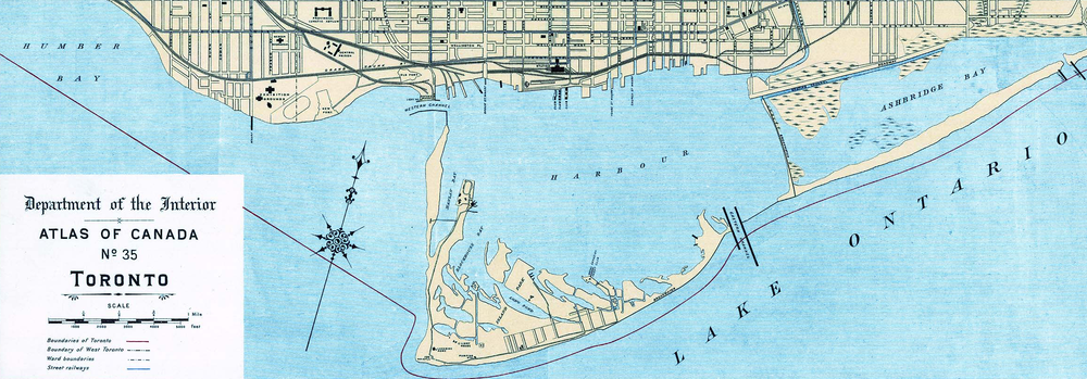
Map of Toronto Harbour in 1906 before the infilling of
Ashbridge's Bay
https://en.wikipedia.org/wiki/Toronto_Harbour_Commission#cite_note-wickson27-2


