News   Nov 27, 2024
 718     4 
News   Nov 27, 2024
 639     1 
News   Nov 27, 2024
 982     0 

Ontario Line Extension West of Ontario Place (Speculation)

It makes me cringe to see people suggest the Queensway/Lakeshore as a potential routing. Line 2 is no where near capacity west of the Humber during rush. The 80 Queensway runs every ~20 mins during rush. Yes, Park Lawn needs additional transit connections.. The planned GO station will give them downtown bound trains every 15 mins. A waterfront LRT to the nearest DRL station will provide an additional connection that should provide significant improvement to the current situation.

Meanwhile south of Bloor in the west end of the Old City, you have:
-63 Ossington operating every 3 mins peak, 22,000 riders over ~7km = 3,142 riders per KM
-47 Lansdowne operating every 4 mins peak, 15,000 over ~10km = 1,500 riders per KM
-29 Dufferin, 44,000 over ~12km = 3,666 riders per km

A corridor 1.5km wide with 2014 ridership at 81,000 riders, with not one stop downtown.

It is important to remember that the Roncesvalles corridor is not a central corridor, it does not see the level of riders as the Lansdowne-Ossington corridor. Nor does it offer the opportunity to relieve all 4 streetcar routes midway into downtown. If you combine the number of riders currently using the Dufferin corridor, with the potential riders who will transfer from all 4 Streetcar routes (5 if the Line is extended to St. Clair), this line would be well used today, IMHO.

It's also important to remember, University south of Bloor is ~at capacity during peak. Line 5 and Line 7 will feed into University when they open in 2 and 4 years respectively. This is a problem that we should foresee.

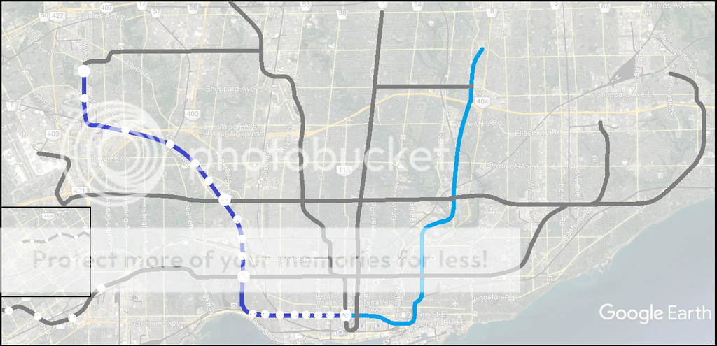
A Dufferin-Jane alignment could offer a long term solution to many of the problems we've collectively identified. This map includes GO lines, proposed GO stations as well as Line 5 and 7 in their entirety for context. The dark blue line is the DRL West. This is a longer version of the previous map I posted on Page 1.

View attachment 173714

Some very solid ideas here. A few suggestions:

- There aren't enough stops. DRL west should have stop spacing similar to line 2. I would add stops at Bathurst and Queen, at Dundas and College with an underground connection to Dufferin Mall, and maybe one at Dufferin and Davenport (close to George Brown?).

- The line misses Parkdale and the important connection to multiple lines at Roncesvalles. How would you address this gap?

- Perhaps Dufferin should get its own subway line while the DRL serves Parkdale, Roncy, the massive coming density hub at Dundas West, the Junction, the Stockyards, then veering north-west to Mount Dennis, Weston, and up Jane into North York as you proposed.

- Taking DRL along the Queensway is insane overbuilding. A surface LRT ROW west from Humber Loop to Sherway is the solution there.
 
I don't really see the Queensway or Lakeshore as options. They do not alleviate any pinch points that can't otherwise be eliminated by upgrading existing infrastructure. Sure maybe one day, but the Dufferin corridor is bursting at the seams approaching maybe even surpassing 100,000 riders, while University south of Bloor is set to hit it's capacity ceiling.

I think the future west end dilemma is another reason why a King St alignment should've been chosen over Queen. That's not to say a subway under Queen isn't necessary (I'd wager both lines will be necessary within 50 years time), but a King alignment would ideally hit Liberty Village GO RER station and swing north along Dufferin. A Dufferin route hits the outer, central core of the old city while also relieving the University line and the various surface routes you mentioned, specifically the Dufferin bus. I believe both subway routes would also allow for a combination of express vs localized routes, with one line containing fewer stops than the other.

A Queen subway would best be suited to traverse Queen entirely, from the Beaches in the east to Sunnyside/Roncesvalles in the west. The Sunnyside stop would ultimately be the Queen line's terminus for some time as any northern/western extensions would depend on development patterns within Etobicoke. Perhaps a northwestern alignment up Parkside-Keele and into Rexdale would be suitable within 75 years. The Sunnyside terminus would serve as a pretty important hub between GO, TTC subway and TTC surface routes.

Pending construction of the Missing Link along the 407 corridor, I've always figured re-routing the Milton GO line under Queensway would be a better alternative to a TTC subway. That line could veer south to the Queensway after Dixie station and travel underground until the Humber River, re-emerging with the Lakeshore GO line until Union. GO combined with a Queensway LRT would be more than sufficient to serve that areas future transit requirements while also creating a better link between Union and central Mississauga. A short branch would even create a direct Square One - Union link as well.
 
Last edited:
I think the future west end dilemma is another reason why a King St alignment should've been chosen over Queen. That's not to say a subway under Queen isn't necessary (I'd wager both lines will be necessary within 50 years time), but a King alignment would ideally hit Liberty Village GO RER station and swing north along Dufferin. A Dufferin route hits the outer, central core of the old city while also relieving the University line and the various surface routes you mentioned, specifically the Dufferin bus. I believe both subway routes would also allow for a combination of express vs localized routes, with one line containing fewer stops than the other.

A Queen subway would best be suited to traverse Queen entirely, from the Beaches in the east to Sunnyside/Roncesvalles in the west. The Sunnyside stop would ultimately be the Queen line's terminus for some time as any northern/western extensions would depend on development patterns within Etobicoke. Perhaps a northwestern alignment up Parkside-Keele and into Rexdale would be suitable within 75 years. The Sunnyside terminus would serve as a pretty important hub between GO, TTC subway and TTC surface routes.

Pending construction of the Missing Link along the 407 corridor, I've always figured re-routing the Milton GO line under Queensway would be a better alternative to a TTC subway. That line could veer south to the Queensway after Dixie station and travel underground until the Humber River, re-emerging with the Lakeshore GO line until Union. GO combined with a Queensway LRT would be more than sufficient to serve that areas future transit requirements while also creating a better link between Union and central Mississauga. A short branch would even create a direct Square One - Union link as well.
I think I understand what you’re saying. The Relief Line should be under King because it will relieve the other two lines while serving the central core, and a second Relief Line should be along Queen as a southern crosstown line?
 
- Taking DRL along the Queensway is insane overbuilding. A surface LRT ROW west from Humber Loop to Sherway is the solution there.

In theory, and with typical 6-car TTC subways yeah it's a pretty out there idea. One thing I'd like to see pursued would be branching, perhaps with less conventional rolling stock for the RL to begin with (though not necessary). So the 6-car main line would do an RL West thing going up to eventually serve North York and Etobicoke on a diagonal. But we also have 2-car trains interspersed in this setup through the core - these veering on a branch along Queensway. The stations on this portion would be built for 2-car (50m long...so not extremely overbuilt).

If serving Sherway it actually solves an issue of what to do with Line 2. Historically bringing it down to Sherway was a plan. But perhaps bringing Line 2 up East/West Mall would in fact be better since it has fairly high and growing density.

Anyway I'm unresolved on how a RL West could be. Just putting it out there that a subway can be more than just a single line with 6-car if we wanted it to be. No reason it can't be both a large subway and a small subway on a single "line" that branches into two lines.
 
South of Bloor, the University line is at Capacity. Therefore Dufferin is not too close to University.
I don't think it's too close to University. I view it as actually having less coverage than if it went farther west.

If going up Dufferin, the last station would be (1) Ossington or Shaw and Queen, and then the big 90 degree curve would begin. The next station would be (2) Dundas/Dufferin. Next would be (3) Bloor/Dufferin. North of Dufferin, you could have (4) Dupont, (5) St. Clair, (6) Rogers, (7) Eglinton, (8) Lawrence, and (9) Yorkdale West. There are no real routes that lead towards the northwest.

If going up Parkside/Keele, stations could be at (1) Ossington or Shaw and Queen, (2) Dufferin/Queen, (3) Landsdowne/Queen, (4) Roncessvales/Queen/King, then the more gentle curve to go up Parkside, and likely an express run to (5) Keele/Bloor (but a nice cut-and-cover portion to save costs). North of Bloor, it would be (6) Annette/Dundas/Keele, (7) Keele/Weston/St. Clair, (8) Rogers/Weston, (9) Eglinton/Black Creek, (10) Lawrence/Jane, (11) Jane/Wilson, (12) Jane/Sheppard, (13) Jane/Finch.
 
South of Bloor, the University line is at Capacity. Therefore Dufferin is not too close to University.

It's not because Yonge south of bloor is full that we should build another line on church street. You can still provide relief to the university line even if the DRL goes north further west than Dufferin. Dufferin can still be considered too close to university.

I agree that the Queensway currently doesn't justify a subway, but you shouldn't just look at the ridership on the Queensway bus. The vast majority of riders in the area take the bus to the subway line 2 as it is faster and more frequent than going on the Queensway bus towards downtown. Royal York South, Islington South, Kipling South all do 10,000 riders over relatively short routes. The majority of those riders are actually downtown-bound rather than northbound.

I think that the relief line needs to hit Queensway & Roncesvale and from there most likely go to Dundas West. That way you can connect all of the GO lakeshore west, lakeshore streetcar, and Queensway transit riders to the relief line. Maybe in the future you could also add a LRT/streetcar on Queensway past humber bay. I think this makes a lot more sense than offering subway service on Dufferin where most destinations are already subway accessible.


Here's an illustration of the alignment I mentioned earlier today. IMO, there's far more trip generators via the Highway 27 alignment (Weston Village, Woodbine Entertainment, Humber College/Etobicoke General Hosp.) than going up Jane, which also can be done for far less expense as it'd be elevated versus tunnel bore underneath Jane Street.
 
I think it's a bit ridiculous to route the relief line all the way up into the Woodbine-Pearson area. That corridor can already be well served by both GO and the UPX, with rapid rail hopefully coming to fruition before Relief Line North. The Finch West line can easily be extended to service the Woodbine area while connecting to both EWLRT and a 427 GO station (which is much more likely than a Park Lawn station, in all honesty).
 
I think it's a bit ridiculous to route the relief line all the way up into the Woodbine-Pearson area. That corridor can already be well served by both GO and the UPX, with rapid rail hopefully coming to fruition before Relief Line North. The Finch West line can easily be extended to service the Woodbine area while connecting to both EWLRT and a 427 GO station (which is much more likely than a Park Lawn station, in all honesty).
Agreed. In the same vein, it's madness to be proposing to build it parallel to the rail corridor. If this MUST be traditional subway the natural western end point really is Dundas West, while this illustration is, to me, above all else another point in favor of building to mainline standard.
 
I think it's a bit ridiculous to route the relief line all the way up into the Woodbine-Pearson area. That corridor can already be well served by both GO and the UPX, with rapid rail hopefully coming to fruition before Relief Line North.
Flip that over: The Relief Line would be better for everyone if it was RER all the way up to Richmond Hill on the eastern end.

Steve Munro's blog update a few days back:
FEBRUARY 5, 2019
Metrolinx Board Meeting: February 7, 2019 (Updated)
Updated February 10, 2019 at 9:00 am: Notes from the Board meeting have been added at the beginning of this article.
Relief Line Business Case

[...]
Staff also reported that although the Relief Line South approved concept (Pape to Osgoode via Carlaw and Queen) has a positive Business Case, the value is only slightly above 1.0. All six of the options were close to 1 and so the distinction between them is not as strong as the simple over/under status in the report might imply. With only a small positive margin, factors such as cost control and encouragement of Transit Oriented Development along the line will be important to maintain the supposed benefit.

CEO Phil Verster argued strongly that building the Relief Line does not preclude building other projects. His concern is to build more transit and build faster. Metrolinx is looking at (unspecified) new technology and innovation from industry to speed up the process. More than one line could be built concurrently, but the critical point is to open them in a sequence that causes the desired redistribution of demand.

Verster admitted that Metrolinx has not done enough to look at the Richmond Hill GO corridor for its potential contribution to relief.

A Board member asked whether the staff have identified a “tipping point” in safety for their studies. There is not a single value, but rather a variation from one location to another depending on local demand, station geometry and passenger flows.

Unspoken through all of this was the years of delay in admitting that a problem even exists, let alone of doing something about it. GO’s ability to provide relief has been downplayed for various reasons including the need to regrade the south end of the line to make it flood-proof, the winding valley route’s limitation of travel speed, and operational conflicts with CN’s freight traffic that limit GO capacity to Richmond Hill. Meanwhile, candidate John Tory’s SmartTrack campaign claimed that his scheme would eliminate the need for a Relief Line, and TTC projections did not raise alarms about capacity and safety issues until the situation at Bloor-Yonge could not be ignored.

“Relief” will not come from any one line or project, but from the contributions of several.

Financing and deliverability studies will be reported in spring 2019 for the Relief Line South, and a preliminary business case for the Relief Line North will be available by year-end.

This entire exchange shows the problems brought on by oversimplified presentation decks for the Board. In their oral remarks, Metrolinx staff displayed a more extensive grasp of the issues and details than contained in the Powerpoint deck.
[...]
https://stevemunro.ca/

I recommend reading the entire piece. There's some gems in there. Particularly note: (Verster) "Metrolinx is looking at (unspecified) new technology and innovation from industry to speed up the process."

Read: "not conventional yesterday's TTC gauge third rail subway"

Also note Metrolinx botching the whole mess for the Relief Line South extension (north) and now indirectly admitting it. They're *still* botching it, along with the TTC. What a shit-show and many Torontonians just accept it at face value. This is *not* the way to build world class city transit infrastructure.
 
Last edited:
I think that the relief line needs to hit Queensway & Roncesvale and from there most likely go to Dundas West. That way you can connect all of the GO lakeshore west, lakeshore streetcar, and Queensway transit riders to the relief line. Maybe in the future you could also add a LRT/streetcar on Queensway past humber bay. I think this makes a lot more sense than offering subway service on Dufferin where most destinations are already subway accessible.

Which locations on Dufferin are subway accessible? Nothing comes to mind, except the vicinity of Dufferin station on Bloor, and in the near future, vicinity of the Eglinton & Dufferin station.
 
Which locations on Dufferin are subway accessible? Nothing comes to mind, except the vicinity of Dufferin station on Bloor, and in the near future, vicinity of the Eglinton & Dufferin station.
Well there is Sheppard West station at the northeast corner of Dufferin and Sheppard.

But good question in terms of the relief line other than at Eglinton and Bloor.
1550013372405.png
 
I think looking at the GTA in the next 30 years, most of the growth will go to the 905 (like it or not), and the bulk of lane*km congestion will be caused by these people. Our best chance at mitigating this problem is creating value in underutilized near suburbs (industrial and single-family corridors near Weston, Black Creek, Jane, Keele, Caledonia, Queensway, Etobicoke, Dixie, Mississauga, etc). I don’t know the best alignment, but an actual analysis of the projected population growth and job growth in these corridors would influence me. My hunch is that we are going to need more than only one DRL, and extensions are going to be constantly competing with Lower-cost LRTs and GO projects. I support them all, but we are going to need a new model to see any of these in my lifetime.

Another thing I think we will need is an actual alternative to a Yonge Subway. I’m talking about a probably-deeper express subway aligned with Line 1 that stops only at Union, DRL, Bloor, Eglington, Shepard, Richmond Hill.
 
South of Bloor, the University line is at Capacity. Therefore Dufferin is not too close to University.

Keele, Weston, and Jane are North York corridors, not Old City. They all have very little significant ridership or density within the Old City. South Kingsway (Jane) south of Bloor through Swansea is not a practical route, neither is Parkside. The only north south corridor that has a consistent urban fabric is Dufferin, with parallel routes ~500m on both sides experiencing significant crowding with a combined 2014 ridership of over 80,000 people.

Roncesvalles can be argued for, for the sake of "connectivity" to create a hub at Dundas West, but this isn't consistent with the needs of the Old City of Toronto. IMO. Which are:

-Reduce crowding on University south of Bloor, a connection to Line 2 west of Dufferin does this less effectively.
-Reduce crowding on the 29 Dufferin, 63 Ossington, and 47 Lansdowne corridor, the only routes south of Bloor in the west that experience significant crowding.
-The 506 particularly has very poor service, how do we increase transit access to this area (Little Portugal, Little Italy)? Duplicity?
-The 504 and 501 need duplicity

It is possible for the DRL to run under Dufferin in the Old City and one of the mentioned suburban corridors in North York.

I don't really see the Queensway or Lakeshore as options. They do not alleviate any pinch points that can't otherwise be eliminated by upgrading existing infrastructure. Sure maybe one day, but the Dufferin corridor is bursting at the seams approaching maybe even surpassing 100,000 riders, while University south of Bloor is set to hit it's capacity ceiling.

This is all just my interpretation of the facts.

Parkside is an unique opportunity to afford builders a relatively cheap route between Queen and Bloor Streets though (cut-n-cover, optional if a Howard Park/Parkside Station midpoint is even needed).

And there isn't much at Dundas and Dufferin to warrant serving with a metro, tbh. In either direction from that intersection you almost immediately encounter single family home dwellings. The 63, 29 and 47 would all be served via the Queen-Parkside alignment too and more destinations align with Queen or points south than they do with Dundas regardless.

Having the DRL depart the east-west alignment too quickly shortchanges everyone immediately west of the departure, namely Parkdale and Swansea. To Roncesvalles means three stops through Parkdale, maximizing coverage and serves St Joe's. I'd even go as far to say a Roncesvalles/Sunnyside GO Station could be built in this area to integrate nicely with the Lakeshore GO corridor and subway. Integration between the Kitchener Line and the DRL could still occur at St Clair, Eglinton, and/or Lawrence.

I think it's a bit ridiculous to route the relief line all the way up into the Woodbine-Pearson area. That corridor can already be well served by both GO and the UPX, with rapid rail hopefully coming to fruition before Relief Line North. The Finch West line can easily be extended to service the Woodbine area while connecting to both EWLRT and a 427 GO station (which is much more likely than a Park Lawn station, in all honesty).

From a network perspective it makes total sense. Rexdale will still be isolated even after FWLRT if it doesn't connect to some form of rapid transit coming from the south. If we were to follow the circuitous routing via a FWLRT extension+Spadina Line from the Woodbine Centre to get to City Hall it'd take over an hour and 15 minutes (assuming optimal surface conditions) versus likely less than 30 minutes per the alignment I drew. And like it or not, using the rail corridors as ROW north of Keele and St Clair far increases the likelihood of it getting built in somewhat immediacy versus 50-75 years from now.

A Jane subway is seriously overrated and would require midblock stations as well. Who's going to pay for subways to Maple Leaf, Falstaff, Exbury, Grandravine and Shoreham when we can't even get the traditional DRL funding guaranteed?
 

Back
Top