


EnviroTO
Senior Member
An Ontario Northland thread got a little off topic so I figured I would bring it here:
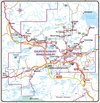
Suggested Improvements to Infrastructure:
Priority 1 map:

Suggested Improvements to Infrastructure:
- Complete Highway 400 to just past Cartier (Geneva Lake interchange) connecting Central Ontario into northern Ontario more quickly. Getting from Sudbury to past Cartier is the slowest part of the trip.
- Upgrade Sultan Road and Secondary Highway 667 to King's Highway standards opening a new faster cross-country route.
- Create a highway running over and replacing Secondary Highway 614, Secondary Highway 625, and Blueberry Rd (Longlac-Nakina) making it more direct than the roads currently there connecting Sault Ste Marie to Nakina and the future ring of fire road.
- Bring Secondary Highway 556 up to King's Highway standards.
- Kings Highway 75 Definition: A highway from Sault Ste Marie (International Bridge) to Nakina Ontario. Resign Highway 17 from Sault Ste Marie (International Bridge) to Wawa as King's Highway 75, have Wawa to the current intersection of Secondary 614 as Highway 17 & 75, sign the new highway to Nakina via Manitouwadge, Caramat, and Longlac as Highway 75.
- Kings Highway 14 Definition: A highway from Sault Ste Marie (International Bridge) to Sudbury Ontario. Resign Highway 17 from Sault Ste Marie (International Bridge) to Highway 400 as King's Highway 14.
- Kings Highway 101 Definition: A highway from the outskirts of Sault Ste Marie (Heyden Ontario) through Timmins to the Quebec border and Quebec Highway 388. Resign Secondary Highway 556 to Highway 101 from Heyden to Highway 129. Resign Highway 129 from that intersection (current secondary 556 and highway 129 intersection) to the current secondary 665 and highway 129 intersection as Highway 101. Resign from that intersection to the current 101 and 129 intersection as Highway 17 & 101. Resign from that intersection to the current 101 & 129 intersection just south of Chapleau to only Highway 101. Resign the highway signage on the section of 129 into Chapleau as Secondary 501.
- Kings Highway 17 Definition: The fastest direct route from the Manitoba border (Manitoba Highway 1) to Highway 417 near Ottawa. Resign Highway 102 as Highway 17 (keep Highway 11 on the current route through Thunder Bay but remove Highway 17 from that route). Reconfigure the intersection of highways in Wawa, and resign Highway 101 from Wawa to Highway 129 as Highway 17, sign the highway from there to what is currently the intersection of Highway 129 and Secondary 667 as Highway 17 & 101. Resign Secondary 667 and Sultans Road as Highway 17. Resign Highway 144 from Secondary 560 down to Cartier (Highway 400 Geneva Lake interchange) as Highway 17 & 144. Sign Highway 400 from Sudbury By-Pass to Cartier as Highway 400 & 17.
- Kings Highway 144 Definition: The connection from Highway 400 to Northeastern Ontario. Signage from the end of Highway 400 to Secondary 560 as Highway 17 & 144, continue to intersection of Highway 101, resign Highway 101 from Highway 144 to Secondary 655 as Highway 101 & 144. Upgrade Secondary 655 to Kings Highway standards and resign as Highway 144.
Priority 1 map:
Last edited: