News   Jul 12, 2024
 1.3K     0 
News   Jul 12, 2024
 1.1K     1 
News   Jul 12, 2024
 394     0 

Miscellany Toronto Photographs: Then and Now

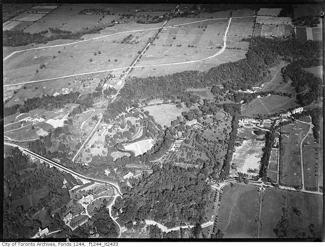
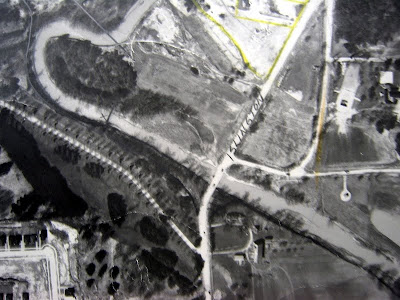
Hard to tell--for all I know, after the high level crossing was built in 1929 it might have been pretty much usurped by the Glendon and/or Chedington estates--and as such, it might even be more "public" (from an accessibility, if not driveability, standpoint) now that it's Glendon College property...

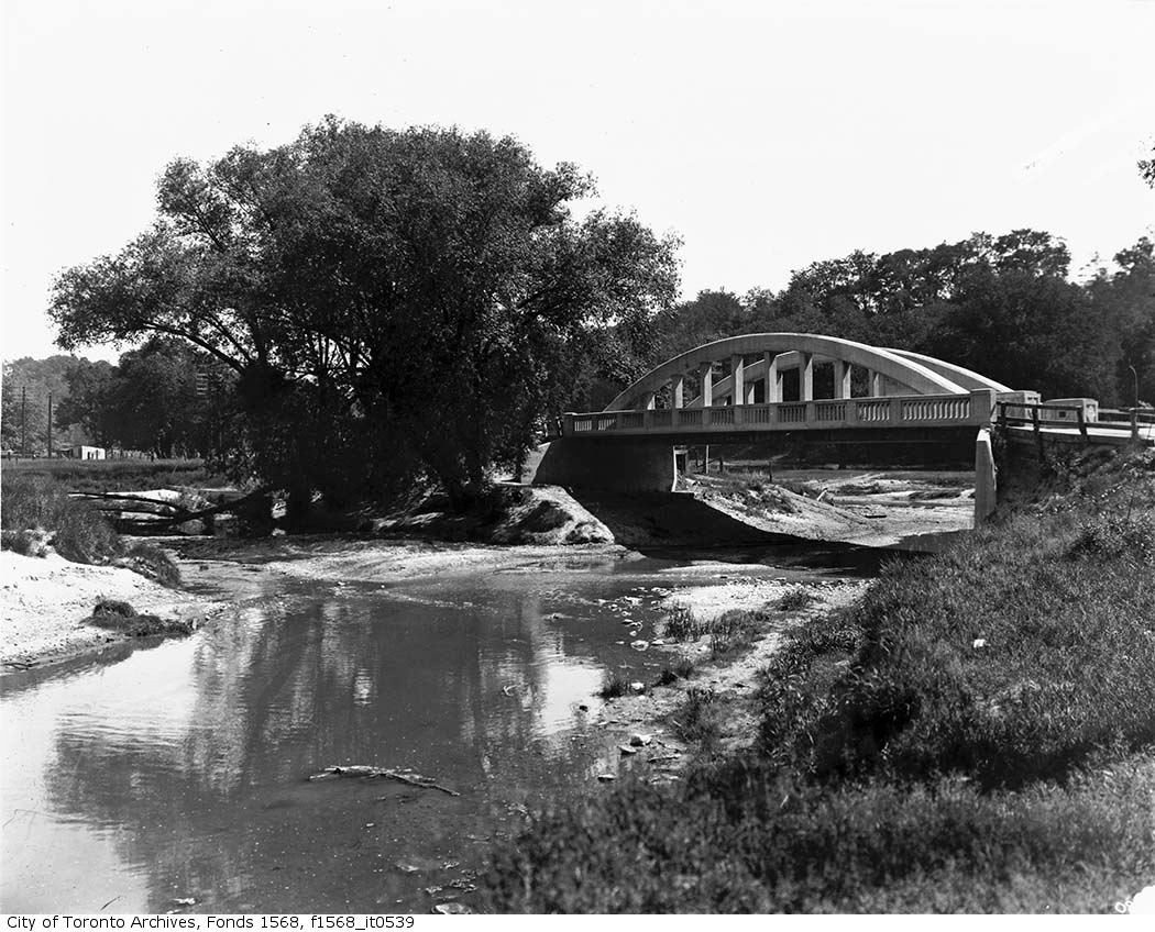
It's hard to get to now. I've been there maybe a half dozen times since the turn of the century (wow, is it time to call it that yet? :)), but it's never been just a piece of cake. There's always been a fence running along the end of Lawrence that segregates the bridge from easy access at that point. Most of the times I've been there, there's been a place to squeeze through worked out by other insistent hikers, but the last time I was there, they'd rebuilt the fence and it required a long detour through the parking lot and down the course of the river itself. I'm in no way averse to that kind of thing but I admit, it's not everyone's cup of tea, especially when they're toting camera equipment.

Heaven knows when they instituted the fence bit. 60s, 70s? Probably before that it was just another footbridge over the Don. These days, it's a minor adventure.

Mind you, you can also get there from the top of the hill on the south side; the trick then is finding a place to park if you're not a local. Roseanne Roseannadanna, it's always something! :)
 
Last edited:
indeed...

77341aef.jpg

b1db3e8f.jpg

f630e544.jpg

6ab7973c.jpg

Those are great shots. :) I would like to see what Queen and Dufferin looked like prior to the start of construction. Did anyone record that?
 
I wonder how well used the space in front of the Gooderham House is. It could make for a nice public space, and that brick and stone wall is starting to crumble.

Except that said wall's part of whatever real-or-likely reasons for designation, so crumbling would be more of an alibi for restoration.
 
Heaven knows when they instituted the fence bit. 60s, 70s? Probably before that it was just another footbridge over the Don. These days, it's a minor adventure.

...or if not a footbridge, maybe a back access road to the Glendon + Chedington estates. (Depends on whether it was under municipal jurisdiction any longer once the high level was built.)
 
...or if not a footbridge, maybe a back access road to the Glendon + Chedington estates. (Depends on whether it was under municipal jurisdiction any longer once the high level was built.)

If I recall correctly, as of about 15 or so years ago, the trail heading south up the hill from the bridge wasn't suitable for anything beyond a 4WD ATV.

Foot access might also be achieved coming from trails to the west of the Bayview bridge, possibly accessible from stairs behind the TFS on Mildenhall (just west of their main campus on Lawrence).
 
Aerial of Bayview and Lawrence 1930:

lawrencebayview.jpg


Two pics identified as "Home of Alf. Rogers, Bayview Avenue":

Could this be the bridge near the Sunnybrook stables?

bayview.jpg


bayview2.jpg
 
Aerial of Bayview and Lawrence 1930:


Could this be the bridge near the Sunnybrook stables?

bayview.jpg

I would bet not for several reasons:

- It looks like it is at a 'Y' intersection of rivers (one from the left, one from the lower left and one on under the bridge). At the stables bridge, there is just the one watercourse heading south.

- It appears to be similar to the bridge down by Don Mills and the DVP:

http://www.bing.com/maps/?v=2&cp=r8hffn8cnzm7&scene=28289902&lvl=2&sty=b

which happens to be right near a 'Y' river intersection (from the north, from the east via Taylor Creek and then the combined river heading south).
 
- It appears to be similar to the bridge down by Don Mills and the DVP

Yeah, I was wondering if that might not be the old Don Mills Road bridge, or possibly the Pottery Road bridge. But I think Asterix is right; all in all, it looks more likely the old Don Mills Road bridge to me.
 
Interesting to look at places that we pass by on a regular basis that look so different from how we know them today.

You can see where my house is today in that first shot of Bayview and Lawrence. :)
 
Aerial of Bayview and Lawrence 1930:

lawrencebayview.jpg


I've seen this shot and a couple of others like it... they do a really nice job of showing the old route. The little bridge in question is just visible as a whitish blob where Lawrence does the (now closed) "L" at the lower left of the picture, near the larger bridge over the Don.
 
One bridge that I've been trying to find a picture of for a long time is the old bridge that used to carry Islington Avenue over the Humber at (what was then the end of) Finch Avenue. There are all kinds of shots of the bridge further south over the West Humber at Thistletown (mostly by James Salmon, who really seemed to favour it as a subject), but I've never yet seen a picture of the bridge at Finch. Anyone know of any?

1950:
1950.png


1960:
1960+206+Islington+and+Finch+3.jpg


1973:
1975.png


Today:
2009.png
 
There is another route down into the valley from the roundabout just inside the Glendon entrance that goes to the lower parking lots. I used to think it was the old path of Lawrence Ave, but it was probably just an access road to those buildings in the valley in the aerial photo. It made an interesting shortcut – a couple of hairpin turns, a bridge over the river (which you can also see in aerial photo), some huge speed bumps – but I think it is now blocked by parking gates.

Here is a shot of the 'in-between' Bayview bridge:
f0217_s0249_fl0011_it0004.jpg


And the 'new' bridge under construction in 1960.
f0217_s0249_fl0011_it0001.jpg

You can see the Sifton's indoor riding ring(?) here which is also prominent in the aerial photo.
 
One bridge that I've been trying to find a picture of for a long time is the old bridge that used to carry Islington Avenue over the Humber at (what was then the end of) Finch Avenue. There are all kinds of shots of the bridge further south over the West Humber at Thistletown (mostly by James Salmon, who really seemed to favour it as a subject), but I've never yet seen a picture of the bridge at Finch. Anyone know of any?

1950:
1950.png


1960:
1960+206+Islington+and+Finch+3.jpg


1973:
1975.png


Today:
2009.png


Thanks for more childhood memories, Lone. Used to play at the Humber near Rountree Mills Park and haven't been up there in a couple of decades, so was sort of shocked to see Finch carry right on through now.

Perhaps someone can refresh my memory, but was there something called "Italian Gardens" on the north side of Finch near Islington? We moved to the area in the early 60s when I was very young, but I clearly remember thinking I wasn't allowed to go to the gardens because i wasn't Italian (I may have this confused with a Baby Point memory ...)
 

Back
Top