News   Nov 08, 2024
 438     0 
News   Nov 08, 2024
 883     3 
News   Nov 08, 2024
 476     0 

Miscellany Toronto Photographs: Then and Now

That's a lovely dog portrait; with the background all out of focus like that. :)


Last night. More 'prowl by night'. 140 Yonge. Lovely reno. I walked over to the side entrance on the south side and saw they had uncovered an old office directory. Urban archaeology without having to travel to say, New York City; where this type of thing is easy to find in plain sight.

P5300024.JPG
P5300020.JPG
 

Attachments

  • P5300020.JPG
    P5300020.JPG
    1.3 MB · Views: 805
  • P5300024.JPG
    P5300024.JPG
    2.6 MB · Views: 941
Then. 1969.

-ish? Going by the cars. Looking like a miniature Chicago. Mid Century and old. Looking N from the waterfront. We are between Bay and Yonge. I may be mistaken, but I seem to remember that the island ferry terminal of that day - a wooden structure that probably dated to the 1920s, was out of frame to the left of the 1960s pic.


The now pic was taken today, Wednesday May 31. The open water on the right of the 1969 pic is still there in 2017 but was blocked by that line of parked cars. And my 17mm lens on a m43 camera wasn't wide enough to take it all in. And I couldn't back up anymore to get 'more' of the shot in. Take my choice of excuses. :)

69 to 76.jpg
P5310025.JPG
 

Attachments

  • 69 to 76.jpg
    69 to 76.jpg
    202 KB · Views: 790
  • P5310025.JPG
    P5310025.JPG
    2.7 MB · Views: 808
Mustapha posted:
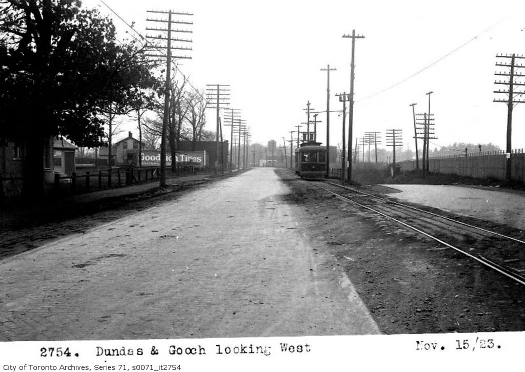
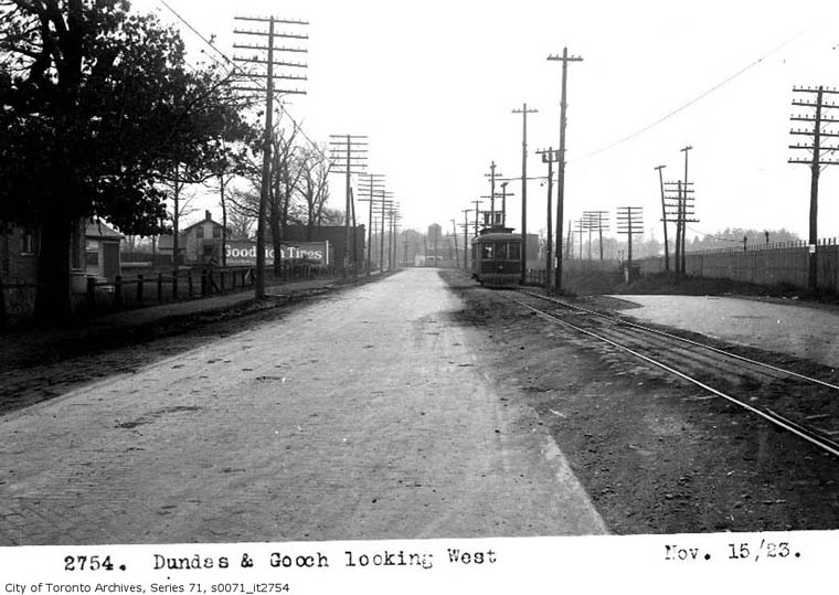
Dundas at Gooch, looking west:
ser71_s0071_it2754.jpg


Note the date "Nov 15/23". Note the 'streetcar'. It may in fact be an interurban if the date is correct. I think it is a "Toronto Transportation" streetcar, and the now TTC track gauge, and those tracks look like they've been freshly dug and re-gauged.

The dates of what this pic shows and the actual day of events in the following may be off a bit, but only by days:
[...]
upload_2017-6-1_21-34-17.png

[...]
https://s3.amazonaws.com/content.si...b07e4a2c1c597edd0f064e4623da7f72a55e294bdace4

Here's more relevant:
http://www.trainweb.org/oldtimetrains/TSR/map_lambton_carhouse.htm
https://en.wikipedia.org/wiki/Toronto_Suburban_Railway

I'm intrigued as to the turn-off road to the right. I question whether this location is actually Gooch and Dundas, I think it may be a bit farther east since Dundas didn't got that straight at that location until the fifties when the new bridge was built over the Humber. If the location stated is accurate, that turn-off would go to the bridge under the CPR tracks to become Scarlett Rd, and Gooch may go left under Dundas from that point.
 

Attachments

  • upload_2017-6-1_21-31-0.png
    upload_2017-6-1_21-31-0.png
    933.7 KB · Views: 227
  • upload_2017-6-1_21-34-17.png
    upload_2017-6-1_21-34-17.png
    342 KB · Views: 990
Mustapha posted:
Dundas at Gooch, looking west:
ser71_s0071_it2754.jpg


Note the date "Nov 15/23". Note the 'streetcar'. It may in fact be an interurban if the date is correct. I think it is a "Toronto Transportation" streetcar, and the now TTC track gauge, and those tracks look like they've been freshly dug and re-gauged.

The dates of what this pic shows and the actual day of events in the following may be off a bit, but only by days:
[...]
View attachment 110673
[...]
https://s3.amazonaws.com/content.si...b07e4a2c1c597edd0f064e4623da7f72a55e294bdace4

Here's more relevant:
http://www.trainweb.org/oldtimetrains/TSR/map_lambton_carhouse.htm
https://en.wikipedia.org/wiki/Toronto_Suburban_Railway

I'm intrigued as to the turn-off road to the right. I question whether this location is actually Gooch and Dundas, I think it may be a bit farther east since Dundas didn't got that straight at that location until the fifties when the new bridge was built over the Humber. If the location stated is accurate, that turn-off would go to the bridge under the CPR tracks to become Scarlett Rd, and Gooch may go left under Dundas from that point.

1923, just four more years before Prohibition ends in Ontario (sort of). At least by 1927, the Township of York, where Dundas and Gooch is located, would become "wet", and just outside the "dry" Toronto West/Junction.
 
I'm intrigued as to the turn-off road to the right. I question whether this location is actually Gooch and Dundas, I think it may be a bit farther east since Dundas didn't got that straight at that location until the fifties when the new bridge was built over the Humber. If the location stated is accurate, that turn-off would go to the bridge under the CPR tracks to become Scarlett Rd, and Gooch may go left under Dundas from that point.

I thought the high level bridge came around 1928. Though the *Old* Dundas bridge stood until Hurricane Hazel in 1954.
 
1923, just four more years before Prohibition ends in Ontario (sort of). At least by 1927, the Township of York, where Dundas and Gooch is located, would become "wet", and just outside the "dry" Toronto West/Junction.
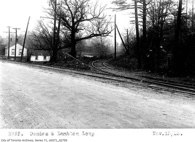
And thus the Lambton Tavern, still open to this day on 'Old Dundas Street' off to the left at the end of where you can see on this pic. The alignment of Dundas "then" is further south from the tracks than it is "now". There's some debate as to whether the Lambton Tavern was moved a short distance back from the road to the present location.
Located on Dundas Highway, a major route in the late 1800s, the hotel was quite busy, and it became a popular picnic spot around the turn of the century. The house survived a devastating fire in 1915 and Hurricane Hazel in 1954. Although it was designated as an historical site by the then City of York in 1985, the building faced the wrecking ball when the last owners vacated the building and sold it to developers in 1988. At the time, it was the longest running licensed tavern in Ontario.
https://en.wikipedia.org/wiki/Lambton_House

Btw: The puzzle of the 'streetcar' may be solved. That car pictured, if it is what I now think it is, was a shuttle between the the Lambton terminus and Runnymede and Dundas (the edge of the City until amalgamation). This may have been the car that ran the Fairview spur when the Interurban ran to the Junction, and since it was standard gauge, retained to be a shuttle from Lambton when the section in the City was acquired by the TTC:
The Lambton car (as the Dundas West service was called) ran from Humberside out to Lambton Park, and a branch, the Crescent route, turned south to Evelyn Cres. & Fairview Ave.
https://stevemunro.ca/2007/04/30/janes-walk-1-the-early-days-of-the-streetcar-system/

[...]
The first street railway to be incorporated on November 12, 1890 under the Ontario Street Railway Act was the Weston, High Park and Toronto Street Railway Company, Limited which was intended to be a horse car operation in Toronto, West Toronto Junction, and York and Etobicoke Townships. Before construction started it was changed in 1891 to the City and Suburban Electric Railway Company, Limited. In October 1892 it began operating its route from Dundas and Keele going west on Dundas to Gilmour Avenue. The following year it was built south to Louisa Street (St. Johns Road), east to Fairview Avenue and south to Evelyn Crescent. It was later extended east along Dundas Street to Humberside Avenue, the City Limits of Toronto where it connected with cars of the Toronto Railway Company which had reached there in 1893. This extension was sold on December 23, 1893 to the TRC which extended its Dundas route over it to a wye in the intersection of Dundas and Keele. TRC double tracked the line from Humberside to Indian Grove leaving the last two short blocks as single track. A planned extension west along Humberside to connect with the west end of the line at Evelyn would have made a complete circuit. It was never built and eventually, the portion south of Dundas to Evelyn was later abandoned (November 28, 1922) for the lack of riders. However, an extension was built in the 1890's westward along Dundas from Runnymede to Lambton Park at the Humber River. This was a side of the road line along the north side of Dundas. The only passing track was at Willard Avenue, two blocks east of Jane Street.
[...]
http://www.trainweb.org/oldtimetrains/TSR/junction.htm

And lo and behold: Regardez!


mainlogoto853.gif

spacer.gif


Toronto Suburban Railway
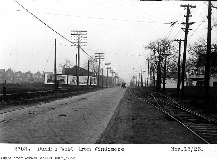
Lambton Line west of Runnymede Road
Township of York


lambton_line_1.jpg


Line and passing track along the side of the road.

lambton_line_2.jpg


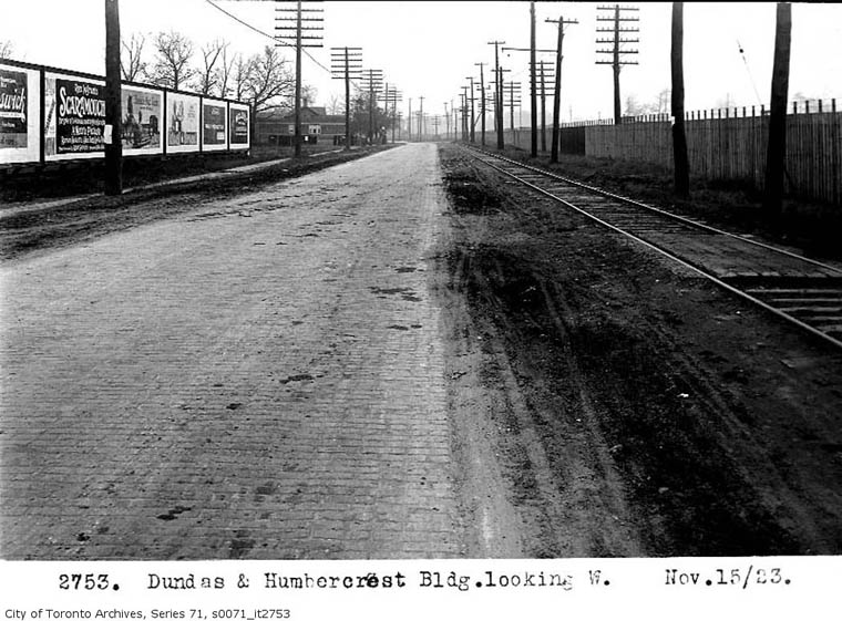
Note the paving bricks near Humbercrest Boulevard.

lambton_line_3.jpg


Looking west along Dundas Street towards Scarlett Road. CPR main line at right with own pole lines.

lambton_loop1.jpg


lambton_loop2.jpg


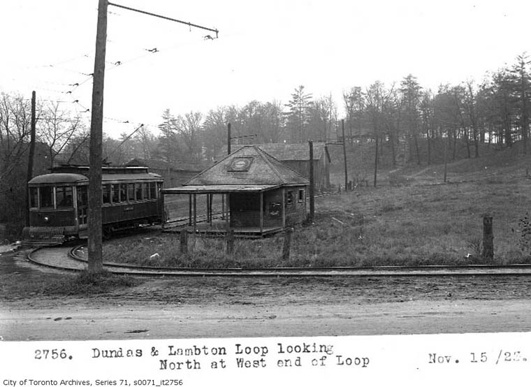
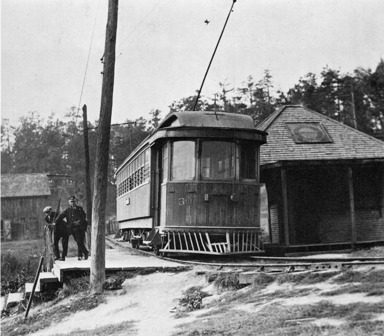
TSR 26 at Lambton loop in park with shelter. Looking northwest. CPR hidden in trees. 1923 Alfred Pearson

lambton_loop3.jpg


Another view of a car in Lambton loop. This one going clockwise. 1922

http://www.trainweb.org/oldtimetrains/TSR/lambton_line.htm

Not stated in the text to these photos is that behind the camera at "Humbercrest" would have been a crossing of the Belt Line that paralleled Humbercrest Blvd directly to the east, and is now the large back laneway.
 
Last edited:
Gooch and Dundas would have been a short walk to the Lambton Golf and Country Club. See link.

The club has been around since 1902, and black and white photos on the clubhouse walls - the stylish clubhouse is modern, having been opened in 2003 - are evidence of its storied history. Club member Geo. S. Lyon won the Olympic gold medal for Canada in 1904, the last time golf was played in the Games. Lyon also won eight Canadian Amateurs. The great players Ted Ray and Harry Vardon played an exhibition at the course during their North American tour in 1913. Ray had won the 1912 Open Championship, while Vardon had won five Opens and a U.S. Open by then.

The club hosted the 1907, 1910, 1925 and 1941 Canadian Opens. Sam Snead won in 1941.
 
I thought the high level bridge came around 1928. Though the *Old* Dundas bridge stood until Hurricane Hazel in 1954.
Still digging on that. It's a good point.

Edit to Add:
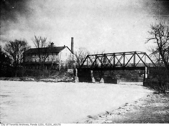
Dundas St. bridge over the Humber

20150117-Dundas.jpg


Numerous bridges carried Old Dundas St. across the Humber River at Lambton Mills. The most recent one was built in 1907 to designs by noted engineer Frank Barber on top of abutments that had been in place since 1880. The metal truss was removed in 1955 following Hurricane Hazel, though road traffic had already been diverted to the current a high-level concrete bridge to the north.

Only the supports at either side of the bridge remain. Both are visible from Old Dundas St. A flood control weir has since been constructed roughly where the structure was located. A little further upstream, another set of concrete abutments mark the old site of another lost Humber bridge, this one used by the Guelph Radial Line--a lost electric railway between Guelph and Toronto.
http://www.blogto.com/city/2015/01/5_lost_bridges_you_might_not_know_existed_in_toronto/

I believe the "current high-level concrete bridge" was built in the Fifties, although I'll look for more definitive reference. I know it was re-engineered in the Seventies/Eighties where the sidewalks were extended and the lanes further widened, and then re-done yet again approx ten years ago....although time flies. I've lived very close to that bridge during two spans of my lifetime.

Evidently just south of the present CPR bridge over the Humber and immediately south of the abutments mentioned for the Guelph Radial above (which is what ran to the Junction, and later by a more northerly route when the City blocked, then acquired and re-gauged their track along Dundas) the broad flat land (flood plain) used to host an annual visiting circus.

It's amazing that we think ourselves so much more advanced and civilized than they were almost a century ago, but one has to wonder at times...Many of those lines (Guelph Radial especially) hosted "campground specials" to fun-parks in the country.

And there's nostalgia for a time before mine again. We may have past-lives...

Late Edit to Add: The Guelph Radial Line ran an express 'train' between the Junction and Guelph (Just to the south of the Speed River and Brock Road) that made the run between Guelph and Toronto *in less time* than the GO train does today...*almost a hundred years ago*! What a trip that must have been for rail enthusiasts back in those days...
 
Last edited:
Still digging on that. It's a good point.

Edit to Add:

http://www.blogto.com/city/2015/01/5_lost_bridges_you_might_not_know_existed_in_toronto/

I believe the "current high-level concrete bridge" was built in the Fifties, although I'll look for more definitive reference. I know it was re-engineered in the Seventies/Eighties where the sidewalks were extended and the lanes further widened, and then re-done yet again approx ten years ago....although time flies. I've lived very close to that bridge during two spans of my lifetime.

There's probably other refs (and are there date markers on the bridge rail abutments?), but I picked this out of the blue

http://torontohistory.net/old-dundas-street-bridge.html

A portion of Dundas became “Old Dundas Street” in 1928 following the completion of the ten-span high-level reinforced concrete bridge to the north. New approaches to the bridge necessitated landfill, which began at Scarlett Road in the east and ended at Earlington in the west. The stone piers of the old bridge are still visible.

==================

It's amazing that we think ourselves so much more advanced and civilized than they were almost a century ago, but one has to wonder at times...Many of those lines (Guelph Radial especially) hosted "campground specials" to fun-parks in the country.

And Eldorado Park endures--in part through the extraordinary cultural resource that is Camp Naivelt.

https://hikingthegta.com/2015/04/13/eldorado-park/
https://en.wikipedia.org/wiki/Camp_Naivelt
 
There's probably other refs (and are there date markers on the bridge rail abutments?), but I picked this out of the blue...
Incredible stuff! I'm still digging on the (newer) Dundas Bridge, it seems part of the divergent history may be due to a *number* of replacement 'concrete bridges', more on that later.

On the reference mentioned a few posts back, the book "Rails from the Junction", by James V Salmon, 1958...I was at Annette Public Library today, just cycling past, and thought I'd drop in to see if they had the book stored in stacks down the basement or some central storage vault somewhere...and lo and behold, it was in a featured local history section on the main floor. Reference only, fair enough.
https://www.google.ca/search?client...-8&oe=utf-8&gfe_rd=cr&ei=OU0yWbGDJeSfXvDEl-AL

It's an absolute treasure trove of information, and the Old Time Trains page copied-in above is from it. It's not that many pages, perhaps 50 or 60, but some fascinating stuff in there, and lots of detailed stunning photos. Just glossing through it I learned many things about the pics above.

I'm going to attempt to take digital photos of some of the pages, and post some of the pics and text in this forum string. I haven't done any serious photography for close to half a century. I was good, worked mostly in 2 1/4 format (mostly 120 film, B&W, the slowest I could find for razor sharp detail) but being young, other interests (mostly electronic engineering....and girls...and things...lol) got me off course. But it's time to get back to it. And slow shutter static shots. High detail and contrast.

Looked into renting gear today at Sutherlands on Carlaw. I know Joe from back in the Village days, he wasn't in, I'll catch him next week, all that his staff knew was digital, and I want to do film....but I might do well to get my 'feel' back starting with digital. lol...it'll be a hell of a lot cheaper as well as simpler! Joe might know exactly the best way to approach this, and have it to rent.

So I'm loving this forum string! It's not only great viewing, it's like being back in college again. Except older and a hell of lot wiser....one hopes.

RE: Camp Naivelt ("Eldorado Park")

There was a very similar one https://en.wikipedia.org/wiki/Idylwild_Park just south of Hespeler on the (later) Grand River Railway, an interurban, now a rail trail I've cycled many times (right down to Port Dover and Hamilton via various branches of other old tracks) and Idylwild has been taken back by riverside swamp, but I have visited the site many times, now virtually inaccessible save for the trail.

I'll continue digging on the Dundas Street Bridge, and hopefully have some pics of my own to post in the next few weeks.
 
Last edited:
Reading back to the first post by Mustapha, and his mention of the Fuji F20 camera that he uses, of which I Googled to learn more, and from the page I found, https://www.dpreview.com/challenges/Entry.aspx?ID=1032097 this pic is featured...this is caviar for hungry eyes:

Waiting for the next train (Baker Street, London, UK)
by Alex Milenkovic

3634195.jpg


Camera:

Canon EOS 7D Mark II
Lens:

Submitted: Saturday, 20th May, 2017 09:14 (GMT)
Taken: Saturday, 15th April, 2017
Focal length: 29 mm
Shutter speed: 1/50 sec
Aperture: F4
ISO: 3200
Notes:
Views: 102

https://g2.img-dpreview.com/6F779C5413F5431DA826E62D20512B33.jpg
 
Incredible stuff! I'm still digging on the (newer) Dundas Bridge, it seems part of the divergent history may be due to a *number* of replacement 'concrete bridges', more on that later.

I believe the piers and *maybe* (or not) the trusses remain the same--regular deck rebuildings seem to be an understandable pattern with these interwar "high level" bridges.

I'm also wondering if it's kin to Frank Barber's Leaside Viaduct--or at least I'm going by how the rebuilt bridge railing echoes the "Claude Bragdon diaperwork" pattern of the rebuilt Leaside railing...
 
Re: the Dundas over Humber bridges: back on page 25/March 1 2009 of this thread I posted some pics of the still very much in good condition stone piers of the Old Dundas Street bridge.
 
Adma: You are correct on 'new' Dundas St bridge. I was there today, plaque states: " 1927, 1973, 2009 ". Upper deck completely new, piers, although completely refurbished, are ostensibly original. Still trying to find a good article on the bridge, have found a number of references stating (gist) "Information is hard to find" on it. It must have been quite the structure when first erected.
 

Back
Top